| Lords of Newselles |
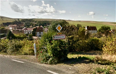
| Hardouin
d’Escaliers (c.1040-aft.1086) was a Norman
noble who came over with William the Conqueror in
1066. His name suggests that he probably came
from the village of Escalles 8 miles (13 km) west
of Calais in the Pas de Calais region of northern
France. The village is near Cap Blanc Nez, the
nearest point in France to the English coast,
just 20½ miles (33 km) away at South Foreland,
east of Dover. One might picture him covetously
eyeing the sunlit White Cliffs of Dover, all too
visible on a clear day, from his native lands. (My thanks to the reader who
alerted me to the possible connection with
Escalles.) |
| On leaving
France behind he naturalised himself as Hardwin
de Scalers and received for his troubles a
large number of domains in Hertfordshire and
Cambridgeshire from a grateful William I
following unsuccessful rebellions of the native
English aristocracy over the four years following
the conquest. He and his descendants established
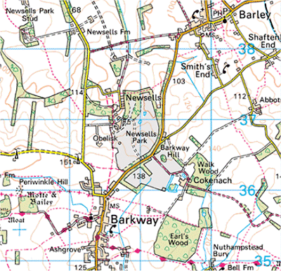
themselves initially as Lords of Newselles
in Hertfordshire, a name to be attached
intermittently to the family for many
generations. The current OS map has the spelling Newsells,
which is 4 miles south-east of Royston in
Hertfordshire, but there is no longer a village
as such. Neighbouring Reed was to become an
important seat of the family. There are the
remains of a number of ancient moated dwellings
and a motte and bailey castle in the area. There
is also a Scales Park south-east of
Barkway. The major Roman Road Ermine Street
passes nearby, which clearly had a strategic
importance. |
| |
| Lands
in Hertfordshire |
| By the time of
the Domesday Book in 1086, Hardwin held a
considerable amount of land around the
Hertfordshire and Cambridgeshire border. In
Hertfordshire, these possessions lay to the south
and west of Royston connected with the villages
of Reed, Therfield, Kelshaw, Hinxworth, Ashwell,
Wallington, Clothall, Rushden, Sacombe and
others. He also had land about 1 mile north of
Cottered at Broadfield, a village that is now
extinct, and a more southerly domain at Little
Berkhamstead about 5 miles south-west of
Hertford. |
| |
| Lands
in Cambridgeshire |
| In
Cambridgeshire, most of Hardwin’s territory
lay in a triangle between Royston, Cambridge and
St. Neot’s connected with the villages of
Caxton, Croxton, Caldecote, Longstowe, Kingston,
Great Eversden, Little Eversden, Orwell, Whaddon,
Wimpole, Shepreth, Little Shelford and others.
Caxton, Whaddon and Little Shelford were to
become further important family seats. |
| The current OS
maps show the remains of many mediaeval moated
dwellings in these Hertfordshire and
Cambridgeshire villages. These moats can not have
been built for defence as they would have been
rather ineffective as such. They are more likely
to have been fashionable status symbols in
imitation of the great castles. |
|
 |
| The
Village of Escalles in Northern France |
| |
 |
|