North Liverpool
Everton including Edge Hill and Kensington
allertonOak  
Last updated 18th October 2017
allertonOak - home page
merseySights - home page
 
 
In the text below, whole paragraphs in italic are quotations from original sources, as follows:
HOE   The History of Everton, Robert Syers, 1830.
ROL   Recollections of Old Liverpool by a Nonagenarian, Anon., 1863.
SIL   The Stranger in Liverpool, Anon., 1812.
TDE   A Topographical Dictionary of England, Samuel Lewis, 1848.
Everton on the Yates and Perry Map of 1768
A Brief History of Everton
The township of Everton lies to the north-east of Liverpool and is bounded by the City of Liverpool and the townships of Kirkdale, Walton, West Derby, Wavertree and Toxteth It was incorporated in the Borough of Liverpool in 1835. It is an ancient settlement but does not appear in the Domesday Book (1086). It appears as Evretona in 1094, a name of Anglo-Saxon origin denoting the enclosure or farmstead of Efer or Eofor (a name meaning wild boar).
Everton's character as a rural village on an escarpment overlooking the River Mersey began to change around 1800, as Liverpool's rising prosperity saw the wealthier merchants, attracted by the views and clean air, begin to establish their homes here.
Everton on Sherriff's Map of 1823
The main road from Liverpool to Everton left town along Town's End Lane and turned towards Everton village as Causeway Lane. On the way it passed a famous pub known as the Loggerheads.
  The road called Everton-brow has, from time immemorial, been the main passage from Liverpool to Everton; its first known name was Causeway-lane, afterwards it long went by the name of Loggerhead Lane, and for the last forty years it has been styled Everton-brow. Until recently, the lower or west end has been honoured with the more dignified title of the Crescent. This road was formerly narrow, and in poor plight. It may serve to give an insight into its former state, and also to shew some other points connected with the neighbourhood of that thoroughfare, to use the words of an elderly gentleman, who well remembered the circumstances of which he treats:
  "The communication (from Everton) with Liverpool was through a deep sandy lane, the cops or hedges on each side not being many yards asunder, nor was there any parapet or foot path to accommodate pedestrians: just within the limits of Liverpool, at a long low house, where the late Mr. Nicholson long resided, was a small ale-house, near to a dyer's pond - the latter surrounded with willows. This public-house was called the Loggerheads, and was of much celebrity in former days, which it first obtained from the civility of the landlady, and the choice and nourishing qualities of the viands and beverage she dispensed". [HOE]
Everton at that time was a popular area among city dwellers for rural walks. Numerous commentators mention the beautiful views (as they remain to this day).
Liverpool from Everton in 1797
There were several very pleasant country walks which went up to Low Hill through Brownlow Street [...]. We used to go to Low Hill and thence along Everton Road, on each side of which was a row of large trees, and we returned by Loggerhead's Lane, and so home by Richmond Row. I recollect very well the brook that ran along the present Byrom Street [one of the streams feeding the Pool], whence the tannery on the right-hand side was supplied with water. [ROL]
The agreeable village or suburb of Everton, denominated, from the salubrity of its air and the pleasantness of its situation, the Montpelier of Lancashire, is seated on a bold eminence opposite to the bay of Bootle [...]. The prospects are very beautiful; and from the western parts of Everton Hill may be seen the fertile lands of Cheshire, the mountains of Wales, the river Mersey, and the expanding Irish Sea with its numberless vessels. From its proximity to Liverpool, it has become the residence of many respectable and wealthy families; numerous streets and crescents have been formed, and the township is studded with handsome detached mansions and villas. [TDE]
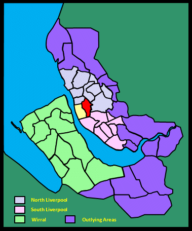
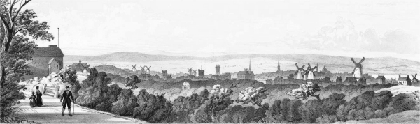
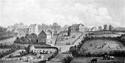
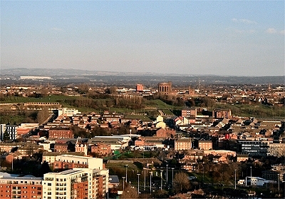
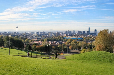
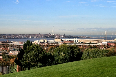
In the summer it was the delight of holiday-makers. A day's out to the 
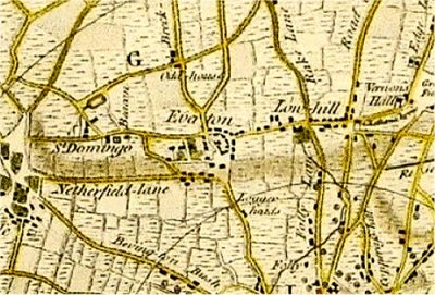
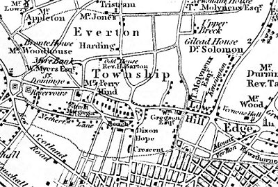
Beacon, at Everton, was a very favourite excursion. The hill-side on Sundays used to be thronged with merry people, old and young. The view obtained from Everton Beacon-hill was a view indeed. And what a prospect! What a noble panoramic scene! I never saw its like. I do not think, in its way, such an one existed anywhere to be compared with it. At your feet the heather commenced the landscape, then came golden corn-fields and green pasture-lands, far and wide, until they reached the yellow undulating sand-hills that fringed the margin of the broad estuary, the sparkling waters of which, in the glow and fullness of the rich sunshine, gave life and animation to the scene, the interest of which was deeply enhanced, when on a day of high-tide, numbers of vessels might be seen spreading their snowy canvas in the wind as they set out on their distant and perilous voyages.
In the middle ground of the picture was the peninsula of Wirral, while the river Dee might be seen shimmering like a silver thread under the blue hills of Wales, which occupied the back ground of the landscape. Westward was the ocean, next, the Formby shore attracted the eye. The sand-hills about Birkdale and Meols were visible. At certain seasons, and in peculiar states of the atmosphere, the hummocks of the Isle of Man were to be seen, while further north Black Combe, in Cumberland, was discernible. Bleasdale Scar, and the hills in Westmoreland, [were to be] dimly made out the extreme distance. [...] The eye moved then along the Welsh hills until it rested on the Ormeshead and travelled out upon the North 
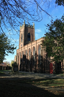
sea. Below us, to our left, was the town of Liverpool, the young giant just springing into vigorous life and preparing to put forth its might, majesty and strength in Trade, Commerce and Enterprise. [ROL]
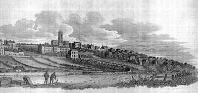
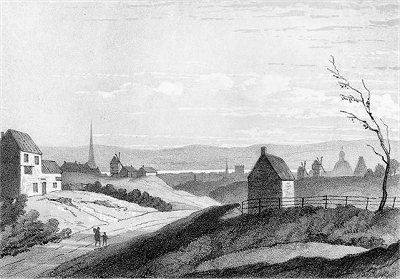
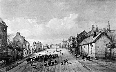
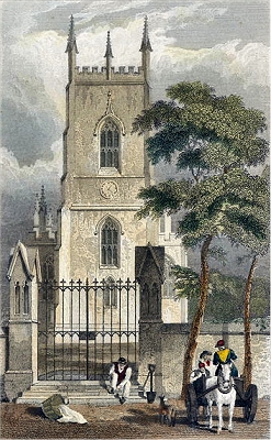
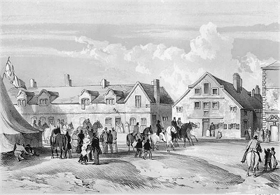
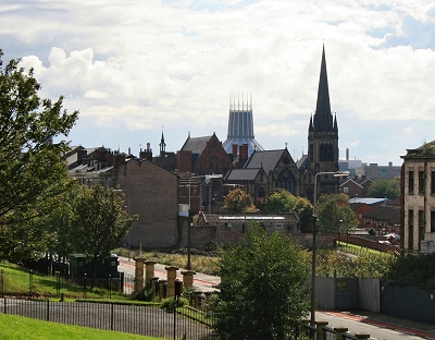
Liverpool from Low Hill c.1840
In 1801, my wife being out of health, I was advised to take her from town. As Everton was recommended by Dr. Parks, I looked about in that neighbourhood, and after some difficulty obtained accommodation in a neat farm-house which stood on the rise of the hill. I say it was with difficulty that I could meet with the rooms I required, or any rooms at all, for there were so few houses at Everton, and the occupants of them so independent, that they seemed loth to receive lodgers on any terms. It must appear strange to find Everton spoken of as being "out of town", but it was literally so then. It was, comparatively speaking, as much so as West Derby, or any of the neighbouring villages round Liverpool, are at present. The farm-house in which we resided has long since been swept away, with its barns, its piggery, and its shippon. Never more will its cornricks gladden the eye - never more will busy agricultural life be carried on in its precincts.
Streets and courts full of houses cumber the ground. No more will the lark be heard over the cornfield, the brook seen running its silvery course, or the apple in the orchard reddening on the bending bough. The lark is represented by a canary in a gilded cage hanging out of a first-floor window, the corn-field by the baker's shop, with flour at eight pounds for a shilling, the brook is a sewer and the apple is only seen at the greengrocer's shop at the corner, in company with American cheese, eggs, finnon-haddies and lucifer matches. Ditch and hedge, the one with waving sedges and "Forget-me-nots", the other with the May blossom loading the evening air with its balmy breath, were as prevalent, at the time I speak about, in Everton, as you will now find in any country district. It was a pleasant place in summer and autumn time. The neighbourhood of the Beacon was our favourite resort. Many a pleasant day we have spent at the top of it. The hill was covered with heather and gorse bushes. In winter it was as wild, bleak, and cold a place as any you could meet with. [ROL]
Everton Brow in 1800
Molly Bushell's Toffee Shop and the lock-up in 1884
Everton Brow in 1843
Cottage in Everton Village
A little further on up the hill from the Loggerheads pub was Molly Bushell's (d. 1818) toffee shop dating from 1753, from where the famous Everton Mints, a delicious and unique black and white striped confection, originated. Nearby was the lock-up, built in 1787. It was known as the Stone Jug (or sometimes the Stewbum's Palace) and was used for minor offenders who would be released the next day or detained awaiting appearance before the local magistrate. It became associated with the containment of disorderly drunks.
An amusing story about the lock-up is recounted in [HOE]. At the time it was built, the High Constable required specially made locks and bolts to be fitted. The local smith saw to this but, as the official and his deputy were inspecting the security arrangements, he locked them in and walked off. Their shouts eventually alerted passers-by, who arranged for their release, not before some choice jokes had been exchanged.
The little square at the top of the hill marked the centre of Everton village, which was beginning to emerge out out rural obscurity by the late 18th century.
  It was only at a comparatively late period that Everton emerged out of a state of rudeness [...]. In the latter part of the last century, a few settlers from the neighbouring town of Liverpool were the first to introduce genteel manners and a polish into Everton society: a few eminent, and some humble merchants of that great commercial town, desirous of relaxation from business, settled themselves on Everton-hill; where, with every advantage of a rural residence, they were still not too far removed from the town's conveniences, and at hand and ready, when required, to aid or conduct their commercial enterprizes. [...] It requires not the inspiration or the gift of a prophet, to predict that Everton is destined to be a place of great consequence; the obscurity, insignificance, and humility in which it lay for many ages past, will shortly be contrasted with proud prospects and brilliant events: its late green sward is fast being covered with magnificent mansions, and multitudes of more humble dwellings. [HOE]
On the village square stood Prince Rupert's Cottage, his headquarters during the Seige of Liverpool in 1644; it was demolished in 1845.
Everton Village in 1840
The lock-up as it is today
Everton Village square c.1840
Prince Rupert's Cottage c.1840
Everton Beacon
The two roads from Everton to Kirkdale were Netherfield Lane (meaning the upper field) and Church Street/St. Domingo Road. St. Domingo was the house of George Campbell, a West India merchant, who made his fortune in sugar from Santo Domingo in the Dominican Republic. He built a sandstone villa there in 1758 and became Mayor of Liverpool in 1763.
  The road from Low-hill to Everton is pleasant and rural. [...] As a village it can boast of a higher antiquity than Liverpool itself, but its present respectability is but of a very recent date. A favourite resort of opulence, it has now an assemblage, of elegant villas, many of which are on a very extensive scale, and connect, with architectural taste, beauty of situation, a commanding prospect, and the decorations of rural scenery. Turning on the left by the Cross, down the hill, and winding round the coffee-house on the right, two roads present themselves, both of which run along the declivity of the hill parallel to each other. The upper one is the most eligible, though at first the most unpromising. After riding a few paces the view opens in a most beautiful and striking manner. Immediately on the left the town of Liverpool is displayed nearly in its full extent; on the right is a range of elegant houses, with shrubberies and gardens disposed in excellent order and good taste; and in front a most extensive view of the estuary of the Mersey, the sea, the extremity of the Wirral peninsula, and a partial view of the northern coast of Lancashire. [...] Quitting Everton, a winding in the road deprives us for a time of this pleasing scene, but it opens again with additional grandeur, especially at high water, at the termination of the ridge of the hill, near a [...] beautiful house which has the appellation of St. Domingo. [SIL]
St. Domingo Road passed Everton Beacon, a large, two-storey, square stone fire beacon that may have dated back to the 13th century and in 1588 was prepared for lighting to warn of the approach of the Spanish Armada. It was the home of a watchmaker in 1770 and a cobbler in 1778, but was gutted by fire in 1782 and finally blew down in a storm in 1803. During the Napoleonic wars in 1804 there was a signalling station on the site. St. George's Church was completed here in 1814.
St. George's Church, Everton
Low Hill c.1840
Everton today from the West Tower
Going south out of Everton, Church Street became Everton Road and then Low Hill as far as Prescot Road. Running east from Everton were Breck Lane and Whitefield Lane (Breck was an old word for uncultivated land). These were crossed by Breckfield Road/Boundary Lane running from Sleepers Hill to Rake Lane; the Odd House marked on the early maps seems to have later become Breckfield House.
Another route out of Liverpool via Everton was Folly Lane and Rake Lane (later Islington and West Derby Road). Folly Lane was named after the folly that once stood at the end nearer the town.
Already by 1830, the town had begun to encroach from the south. As the 19th century progressed, the expansion of the docks northwards and the arrival of a chemical works and other industries radically changed the character of the area. During the second half of the century, the wealthy began to move out and their great houses were replaced by back-to-back terraces to accommodate the influx of workers, many of them Irish immigrants. This caused Everton to become an area of sectarian conflicts between Catholics and Protestants until well into the 20th century. By 1875 Everton Road had become 'a dense thoroughfare of a somewhat shabby and second rate character'. By 1896, Everton 'had long been deserted by the rich and influential residents'.
Everton Football Club was founded as St Domingo FC in 1878. Passing into the 20th century, parts of the area degenerated into squalid slums. Bombing during World War II added to the devastation. After the war, much of the area was bulldozed and in the sixties the housing was replaced high-rise blocks that broke up the old communities and were destined to become infamously squalid in their turn. Nowadays most of these have gone and the area is largely one of open green spaces and low-rise modern housing. However, the population is much reduced and many of those who remember once living in the area regret the changes.
The Folly
St. George's Church
St. George's church, on the highest point of Everton Hill, was designed by Thomas Rickman (based upon the preliminary work of Joseph Gandy) and built by John Cragg. Cragg made his money as the owner of the Mersey Iron Foundry in Tithebarn Street, Liverpool, and was keen to exploit his business in the construction of churches. He was a founder member of the Liverpool Athenaeum, where he probably met Rickman. Rickman was self-taught as an architect, but became an authority on Gothic architecture (he is credited with introducing the term perpendicular in this context) and was a key figure in the Gothic revival in church design in the 19th century. St. George's itself marks the definitive transition to this style.
Cragg was by all accounts a difficult character who was at odds with the more conciliatory Rickman throughout their collaboration, constantly plagiarising his work and interfering with his designs. St. George's was completed in 1814 and was probably the first building where standardised prefabricated cast iron parts (patented by Cragg) were used on a large scale for building frames and windows with a view to re-using the moulds elsewhere and achieving large cost savings. In fact, many of the casts were reused for St. Michael's in the Hamlet, Toxteth, and St. Philip's, Hardman Street (demolished).
The use of cast iron in the interior of St. George's has allowed the supporting structures to form a delicate tracery with a feeling of light and space. The roof panels are large sheets of slate from North Wales. Stained glass windows were not part of the original building, being added in the second half of the 19th century. Many of these were destroyed by bombing in 1940 (only one remains undamaged) and have been since restored. The new East Window was dedicated in 1952 to the memory of air-raid victims.


St. Francis Xavier's Church
St. Francis Xavier is the largest catholic church in the city. It was designed by Joseph John Scoles and opened in 1848; the spire was added in 1883. The church was built to accommodate the growing number of Roman Catholics in Liverpool, largely a result of Irish immigration. Although designed to hold 1,000 people, by the 1880s the space had become insufficient and in 1888 an extension, the Sodality Chapel, was opened. Together with the adjoining former college (1876-7) and schools (1853-7), it was the 19th century's most extensive group of religious buildings in the city. The poet and priest Gerard Manley Hopkins preached here. The church was extensively damaged during World War II and by the 1960s was in decline following the exodus of most of the parishioners to other parts of the city. It narrowly escaped partial demolition in the 1980s but was restored in time for its 150th anniversary.
View from Shaw Street
Everton Park and St George's Church
Panorama of Liverpool city centre from Everton Park
Wallasey and the Tobacco Warehouse
Everton Park
Until the late 18th century, this was a rather wild place associated with quarrying and millstone making. In 1770, one writer notes: Heath, gorse and weeds are its general crop and unsightly patches of barren, ill-enclosed land displease the eye at every glance. As late as 1812, highwaymen were still active in the district. Even so, by 1800 it was becoming a much more desirable place to live, with its fabulous views and clean air, and the wealthy began to establish villas here. It was also a popular destination for those out for a stroll from Liverpool.
With the burst of industrialisation in the 19th century and the resultant influx of impoverished workers, much of this area became covered with densely packed rows of back-to-back houses. Nowadays we have the huge green space of Everton Park, created in the early 1980s. The panoramic view over Liverpool towards the Wirral Peninsula and the Welsh hills is one of the best in the area.
Liverpool's 'Dreaming Spires' from Everton Park
Snowdonia and the Waterloo Dock warehouses
Towards New Brighton
Liverpool Collegiate Institution
The Jewish Cemetery
Miscellaneous
Liverpool Collegiate Institution, Everton: The Liverpool Collegiate Institution, opened in 1843, was the first of the great English Victorian public schools. It was designed by Harvey Lonsdale Elmes, of St. George's Hall fame, and built of Woolton Quarry sandstone. The facade is just about all that remains of the original building following a fire that gutted it in 1994. The rear has been redeveloped as elegant modern apartments.
Everton Water Works: The 85ft (26 m) high water tower of Everton Water Works was built in 1857. The adjoining Italianate pump house was built at the same time, with a second one being added in the 1860s. Liverpool Corporation assumed responsibility for water supply in 1847, replacing an increasingly inadequate service based upon piping local well water or selling it from carts. They began the construction of out of town reservoirs 25 miles (40 km) away at Rivington in the Pennines in 1852 with delivery beginning in 1857. The Corporation Water Engineer Thomas Duncan began the construction of imposing reservoirs in the highest parts of Liverpool. With increasing demand, the damming of Lake Vyrnwy in Wales was begun in 1881 with delivery from 1891.
The Jewish Cemetery: The site for the Jewish cemetery on Deane Road, Kensington was purchased in 1835 at a time when the Jewish community in Liverpool was growing rapidly in size and wealth. It was consecrated in 1837 and burials continued on a regular basis until 1904 (the last recorded burial took place in 1929). It is the resting place of many eminent Victorians, perhaps most the famous being David Lewis (1823-1885) of department store fame, and contains a number of imposing monuments. The site subsequently fell into decay, but in 2010 a Heritage Lottery grant of £494,000 was awarded for restoration work. The project will renew important features such as the ornate Grade II listed archway, re-erect and clean fallen gravestones, and create a visitor centre and formal garden. It will also allow the cemetery to be opened to the public.
Edge Hill Station: This is the second station building at Edge Hill, the oldest passenger railway station in the World. The original station of 1830 served a passenger terminal uphill at Crown Street and the Wapping Tunnel, a long incline leading to Wapping Dock. On these inclines, goods wagons descended by gravity but were hauled up by a winding engine. It was soon decided to divert passenger traffic via a new tunnel to Lime Street Station. This required a new station at Edge Hill just to the north (the present one). Both stations were opened in 1836. Initially gravity and winding engines were also used on the stretch to Lime Street. The station linked passengers to Manchester via George Stephenson's Liverpool and Manchester Railway, opened 1830 in the presence of the Prime Minister, the Duke of Wellington. There was a tragic accident at the event in which Liverpool MP William Huskisson crossed in front of a loaded passenger train to speak to the Prime Minister and was knocked down by the famous Rocket locomotive, later dying of his injuries. Edge Hill station was restored in 1979.
Everton Water Works


Edge Hill Station
 
Acknowledgements and Further Reading
For more on the architecture, see as usual the indispensible Pevsner Architectural Guide: Liverpool by Joseph Sharples, Yale University Press, 2004.
The engraving of Everton Brow in 1800 is from De Quincey in Everton. Many of the images are from the wonderful resource Ancestry Images, in turn sourced from Lancashire Illustrated, 1831/6 (St.George's Church, Everton, engraved by J. Thomas after a picture by G. & C. Pyne) and Pictorial Relics of Ancient Liverpool, engraved by W.G. Herdman, 1843 (Everton Beacon, Everton Village Square, Everton Village cottage, Everton Brow in 1843, The Folly, Liverpool from Everton in 1797 from an original drawing, Liverpool from Low Hill, Low Hill, Prince Rupert's Cottage). Molly Bushell's Toffee Shop is from Flickr account Penlinken. Everton Village in 1840 is from the Liverpool Echo. My thanks to all of the above.
This is a non-commercial website that is intended entirely for research and educational purposes. If I have unintentionally breached copyright with any images, I hope that the copyright owner will tolerate my usage in the present context, otherwise I will remove the material. Modern colour photographs are by the author.