|
|
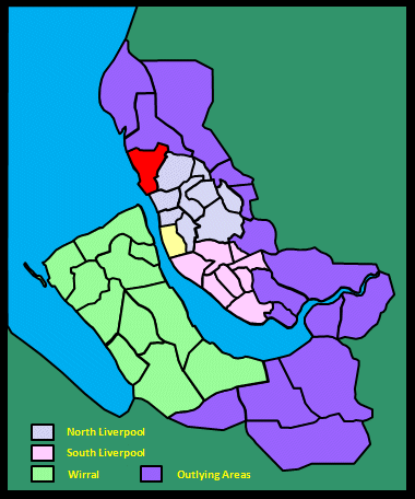
|||||||||
|
|
|||||||||
| Home Page: merseySights |
Home Page: allertonOak |
|||
 |
| CLICK A BOOTPRINT FOR A RELEVANT WALK - LINKS TO OTHER SITES AT THE BOTTOM OF THE PAGE |
 |
Seaforth
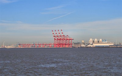
Container Port Royal Seaforth Dock is a purpose-built dock and container terminal. Work on it began in the 1960s and it became Liverpool's largest dock and, at the time, the largest in the UK. It is connected to neighbouring Gladstone Dock, which provides an entrance to the river via its lock system. The site covers 5000 acres (2000 ha) with 85 acres (34 ha) of water. Liverpool 2, undergoing a phased opening from 2016, will double the container capacity of the port by admitting all but the very largest container ships. |
|
| Seaforth in Liverpool
(1907) by Dixon Scott As for Seaforth itself, [...] it, naturally, is the least personable of [the chain of northern seaside settlements]. 'The slums of the future', say the pessimists sententiously; and already a notable greyness begins to creep over its tightly packed workmen's cottages. It seems especially deplorable, for the shore of the place (unbelievably peppered in the summer heats with naked pinkish youngsters) is clean and fair enough; New Brighton glitters pleasantly across the estuary, the Welsh hills heave up in the distance, and the great ships of the world promenade before its parlour windows. |
||
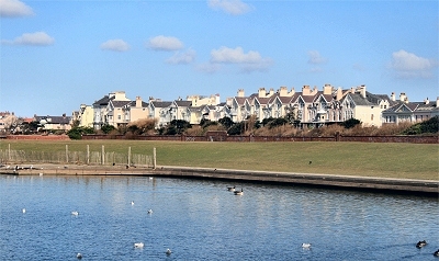 |
Sea
Captains' Villas, Waterloo Elegant Victorian Villas (completed mid-1870s) on the seafront at Waterloo from Crosby Marine Lake with the walled public gardens in front. They are known locally as the Sea Captains' Villas. Thomas Henry Ismay, founder of the White Star Line, built one for himself in 1865 and was behind the development of some of the others. Waterloo takes its name from the Royal Waterloo Hotel (now simply the Royal Hotel) of 1816, which opened when the area was first becoming of interest as a bathing resort. When I was a kid in the 1950s, you walked down between the gardens at the end of South Road and the beach was just there; it reached right up to Gladstone Dock to the south. There were pyramidal concrete tank defences along the shore. During the 1960s, this area was subject to redevelopment on a huge scale, with the construction of Seaforth Freeport (opened 1972), the Marine Lake and the waterfront promenade. |
|
| Waterloo in Lewis's
Topographical Dictionary of England (1848) This village is beautifully situated on the coast, near the mouth of the river Mersey. It is a favourite sea-bathing place, remarkable for the firmness of its sands, the clearness of the water, and salubrity of the air; and is much frequented by families from Liverpool. The village consists of several ranges of commodious houses, a fine marine crescent, and some excellent hotels; commanding prospects of the entrance to the Mersey, and the port of Liverpool, with parts of Cheshire, and the northern coast of Wales. |
||
| The view at Crosby in Liverpool
(1907) by Dixon Scott [...] a bold and various prospect. On the one hand the level floor of the sea, here dusked, there silvered, marbled by voyaging clouds, runs out until it meets a wide pure sky. Poised at the western extreme of the long horizon blade, Anglesey rests like a sapphire, and the hem of all the air that sweeps away to the south is braided thereafter by the woven hills of Wales. From them the eye stoops successively to the shimmering aura of the Dee, to the embossed interspace of the Wirral, to the bright-mailed river down below. [...] Unfolding between [the] spreading blackness [of the city] in the south and a rim of purple woodland in the north, a fair carpet of meadowland and cornfield runs clear and away. A rare white farm or so, set in that green tranquillity, invest it with a kind of homely joy. |
||
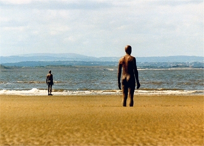 |
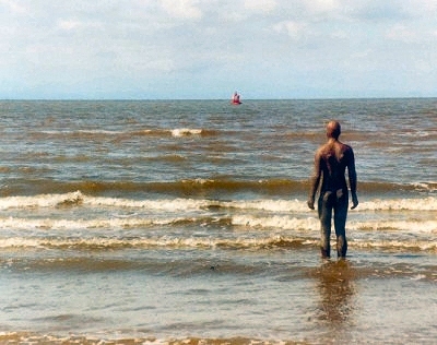
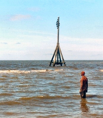
Antony
Gormley's Another Place,
Waterloo In front of the waterfront promenade at Waterloo there is a fine long stretch of golden sand that is usually almost empty. Here there are superb views over the sea towards the Wirral and North Wales. This is the appropriate setting for the start of Antony Gormley's haunting shoreline installation Another Place: 100 life size rusting cast iron figures gazing out to sea from here to the estuary of the River Alt. |
|
 |
Antony Gormley's Another Place, Waterloo | |
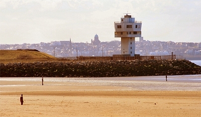 |
Crosby Radar Station and New Brighton | |
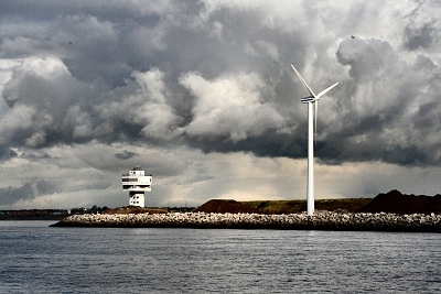 |
Crosby Radar Station | |
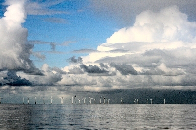 |
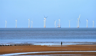
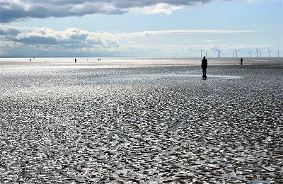
Wind
Turbines off the Crosby Shore Modern day wind turbines are, of course, used to drive dynamos to generate electricity. The first such was the work of the Scot James Blyth, who used wind power to charge batteries to light his home, and they remained a competitive source of electricity in isolated areas for many years. The first wind turbine connected to the electricity grid was built by John Brown and Co. in Orkney in 1951. The huge recent growth in wind turbines is due their 'green' credentials: they are a renewable source of energy with low climate impact (only in manufacturing). They remain controversial. Production costs are high, energy return from wind is much lower than from water (hydroelectric or tidal) and the visual impact on the environment often regarded as undesirable. |
|
 |
Wind
Turbines off the Crosby Shore A scouse joke follows: A scouser is taking his dog (one eye, a chunk missing from one ear, mange, a limp - you get the idea) for a walk along the shore at Crosby one day when he sees a rusty-looking object lying on the tide-line. He gives it a peevish kick and there's a puff of smoke and out pops a genie. Genie: 'I am the Genie of the Lamp! Your wish is my command!' Scouser: 'Nice one mate! Er, 'ow about fixin' it fer Tyson 'ere ter win at Crufts?' Genie: 'Ah, my powers are indeed great, but there are limits to what even I can achieve.' Scouser: 'Er, let's 'ave a tink den. I know, 'ow about gerrin' Everton (Liverpool, Tranmere, depending upon your audience) to win The Cup?' Genie (after a pause): 'Let's have another look at that dog.' |
|
 |
Antony
Gormley's Another Place,
Hall Road As kids in the 1950s, we used to paddle and bathe here, but I hate to think what the state of the water was back then. Tiny little shrimp-like creatures used to nip at us. Still, it's all good for the developing immune system, I suppose. Everything is much cleaner now, of course. |
|
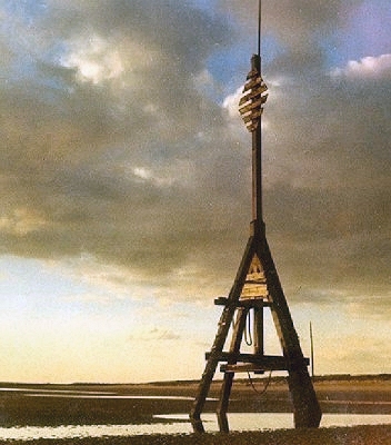 |
Landmark
near Hall Road An old landmark on the Irish Sea shore just north of Liverpool. This is one of two measured mile markers (the other, at Crosby, no longer there) once used by shipping to calibrate their speed instruments when leaving the Mersey estuary. (My thanks to Paul Fairfield for this information.) |
|
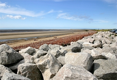 |
The
Shore North of Hall Road This is the view north from Hall Road to Hightown showing the sea defences. My thanks to Don Garton for this and the following picture (and his thanks to Ansel Adams, no doubt). |
|
 |
The
Shore at Hall Road An atmospheric shot over the sands. |
|
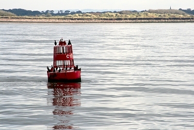 |
A
Bouy off the Crosby Shore With cormorants. |
|
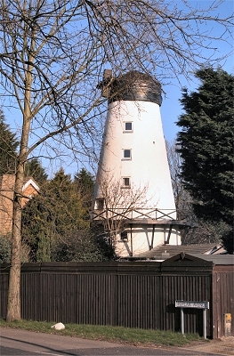 |
The
Old Mill, Great Crosby The Old Mill, located at Great Crosby's highest point, dates from 1813. |
|
| Great Crosby in the Victoria
History of the County of Lancaster (1907) The ancient township of Great Crosby, which includes Waterloo, lies on the northern shore of the estuary of the Mersey, with a level sandy beach extending over three miles from north-west to southeast [...]. The country is flat and sandy, being in places still very marshy, so that deep ditches, especially in the north, are required to drain the fields and meadows. The crops grown are principally oats, rye, and potatoes. At Hall Road there are golf-links on both sides of the railway, and a broad stretch of sandhills, yet unbuilt upon, extends along the northern half of the sea coast. [...] The village, which lies more than a mile inland, is becoming modernized and growing quickly [..]. An electric tramway connects Great Crosby with the Seaforth terminus of the Liverpool Overhead Railway. The township of Waterloo has been carved out of the southern part of Great Crosby. To the north of it are Brighton le Sands and Blundellsands; these places consist principally of modern residences, which afford Liverpool people convenient dwellings at the seaside. [...] Crosby Channel forms the principal entrance to the Mersey; it is about three-quarters of a mile wide. By constant dredging a sufficient depth of water for the passage of the great liners is maintained. There is a lightship in the channel. [...] The Crosby races used to be held once or twice a year - the first week of August was the proper time - on a course on the shore side of Great and Little Crosby [...]. The little triangular green of the village is now paved. Here is the ancient St. Michael's Well, which has been covered in, and is surmounted with steps and a wooden cross. |
||
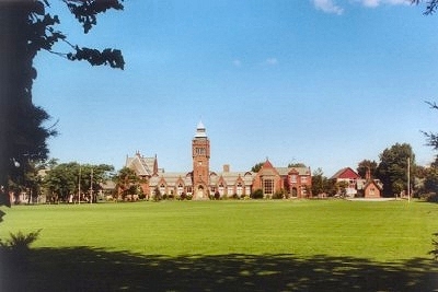 |
Merchant
Taylors School, Great Crosby A Merchant Taylors School was first established in Crosby in 1620. This is now the girls' school. This Gothic building, the boys' school, just down the road, dates from 1878. It was your devoted writer's alma mater from 1961 to 1968. I recall the teachers in the 60s being a mixture of the progressive and the Dickensian. I'm still impressed with being asked for English homework in 1963 to write scenes in the style of Harold Pinter and Eugene Ionesco (then considered avant garde), and with being played records of Bartok string quartets by one of the physics teachers after sixth form exams were over. I was taught Latin, on the other hand, by a follower of Wackford Squeers. |
|
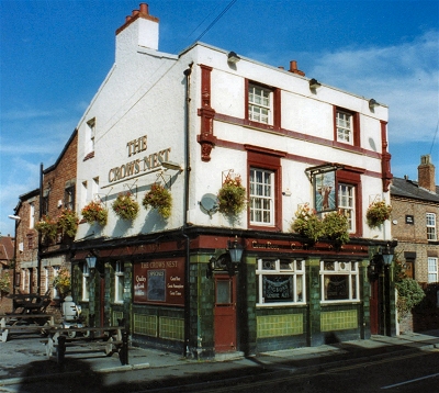 |
The
Crow's Nest, Crosby A traditional suburban local, nicely appointed inside and out. Crosby is not exactly awash with decent pubs and this one is most welcome. |
|
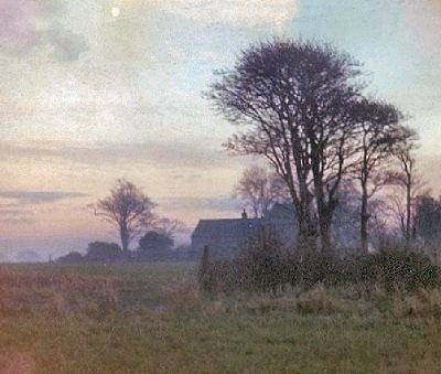 |
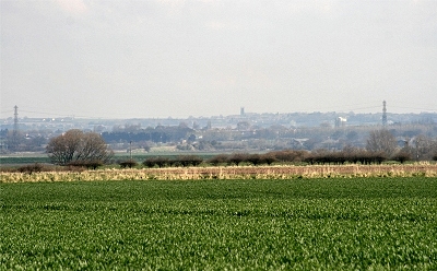
Farmland
near Thornton Thornton is at the extreme northern edge of the Liverpool conurbation. This is typical of the flat agricultural land that starts here, bleak and brooding on a freezing winter's afternoon. About 100 years ago it is said to have been a village much resorted to by pleasure parties. Slightly more recently it was where Iived as a teenager. |
|
| Thornton in the Victoria
History of the County of Lancaster (1907) This township [...] is situated in flat country consisting of pastures and cultivated fields. The soil is loamy, producing crops of potatoes, turnips, and corn. The pastures near the Alt lie very low and are often flooded in winter-time and wet seasons. Trees are not a prominent feature of the open landscape. [...]. In the summer the village is much resorted to by pleasure parties. The road from Sefton to Great Crosby passes through it. To the north-east is a hamlet now called Homer Green, formerly Hulmore. There is the pedestal of a cross called Broom's Cross. An ancient sundial on a stone pillar stands on Thornton Green; close to it are the stocks. Dialect words in colloquial use which may be noticed here are 'neave' for fist, 'narky' for fractious [surely more widely used?], and 'coi ammered' or 'cain ammered' for testy or contentious. |
||
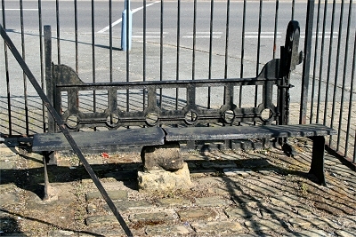 |
Stocks,
Thornton The present Thornton stocks date from 1791, when they replaced an earlier set. They continued in use as late as 1863. The damage visible was caused when a truck collided with them during a blackout in World War II. |
|
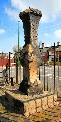 |
Sundial,
Thornton Sundials were a common feature of Lancashire villages. The sundial here in Thornton predates 1720, making it possibly the oldest surviving example in south-west Lancashire. |
|
 |
Aughton
from Broom's Cross, Thornton This is the view towards Aughton from Brooms Cross. The pedestal survives of an ancient resting place for coffin bearers en route to Sefton Church. |
|
| LINKS |
| Merchant Taylors School |
| Antony Gormley's website |
| Antony Gormley at artsy.net |