|
|
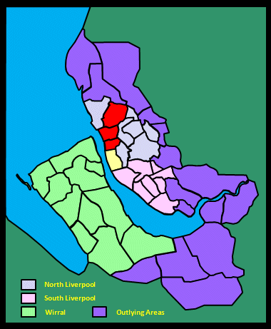
|||||||||
|
|
|||||||||
Home Page: merseySights  |
Home Page: allertonOak  |
|||
 |
| CLICK A BOOTPRINT FOR A RELEVANT WALK - LINKS TO OTHER SITES AT THE BOTTOM OF THE PAGE |
| Kirkdale in Lewis's Topographical Dictionary of England (1848) The township derived its name from its position midway between the town of Liverpool and the parish church of Walton-on-the-Hill, which, previously to 1700, was the parish church of Liverpool: as the road from the town to the church lay through a hollow part or gentle vale across this township, the place was called Chirkdele, now Kirkdale. Of the families which held lands here soon after the Conquest, was one of the local name. The Waltons were connected with the township in the reign of Henry III.; and the family of More, or de la More, established themselves here in 1280, and built a seat near Liverpool, called More Hall, which, with Bank Hall, was in their possession for upwards of twenty generations. The latter mansion was situated near the sea; it was a curious model of the style of architecture that prevailed five centuries ago, and was then esteemed a very grand structure. [...] Bank Hall was totally demolished in 1778, and a neat farmhouse was built on its site: the house and farm are now the property of the Earl of Derby. [...] The vicinity of Kirkdale to Liverpool, with which town it is now joined, has greatly and rapidly increased the population, and the value of the land, on which several hundred houses have been erected within the last fifty years. [...] On an elevated spot here, opposite the mouth of the Mersey, and distant from it about half a mile, stands the County Gaol and House of Correction, covering an area of five acres, and surrounded by a wall 27 feet high, the western portion of which was blown inwards by the hurricane of January 6th, 1840, but immediately restored. [...] The whole of the prison is in course of being rebuilt on the plan of the model prison at Pentonville [...]. The new building consists of four wings projecting at right angles from a great central hall, each wing having accommodation for 120 prisoners in separate cells, besides workrooms, baths, &c., on the basement. The chapel stands between two of the wings, near the hall, and the interior, arranged as the segment of a circle, affords space for 400 prisoners, each in a separate stall, so as to prevent them from seeing each other, while all are visible to the chaplain and the officers of the gaol, in front. |
||
| Kirkdale in the Victoria History of the County of Lancaster (1907) With a frontage to the Mersey of a mile in length, Kirkdale [...] occupies the level ground between Everton and the river, a large part of which was formerly sandhills, and the village lay at the foot of the hill, on the north-west side of the road from Liverpool to Walton. To the north rose a brook which ran down to the river by Bank Hall. [...] Like other townships absorbed by the growth of Liverpool, Kirkdale is a mass of buildings, chiefly small cottage property, the dwellings of the working classes, mixed up with factories and warehouses, railways, and shops. There are no natural features left, scarcely a green tree to relieve the monotony of ugly buildings and gloomy surroundings, save in some old enclosure that was once a garden. [...] The Overhead Railway runs along the line of docks, with several stopping places; and the Liverpool tramway system has many lines in and out of the city and across. A large part of the shore side of the township is occupied with railway sidings and stations in connexion with the dock traffic. The portion of the dock system within the township limits includes Sandon Dock, with its large graving docks; Huskisson Dock, with two long branches, and Canada Dock with its branch. |
||
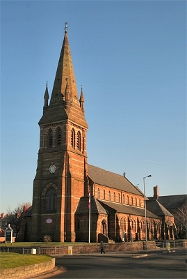 |
Christ Church, Bootle This elegant and imposing church was completed in 1866. |
|
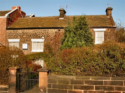 |
The Old Hall, Bootle Bootle grew from Saxon times, appearing in the Domesday Book, around the important Bootle Spring, in a square area bounded on three sides by Litherland Road, Merton Road and Hawthorne Road). This cottage opposite Christ Church, called the Old Hall dates from ca. 1770 and was once a hunting lodge owned by the Stanley family. It is one of the few reminders of the more distant past in this area. The spring itself was, appropriately enough, near the junction of Well Lane and Waterworks Street; nearby there is also a Mill Lane. Waterworks here once supplied Liverpool with fresh water. The little river known as the Mill Stream that flowed out of the spring was dammed twice near to its outlet at Alexandra Dock, the lower one powering a watermill. By the end of the 18th century, Bootle was something of a seaside resort. |
|
| Bootle cum Linacre in History of Liverpool (1774) by William Enfield Bootle cum Linacre lies near the sea on a very sandy soil and contains some well-built houses. A very copious spring of fine, soft, pure water rises near it, which about half a mile below turns a mill and soon after falls into the sea at Bootle Bay. [...] Linacre, a pretty rural village, is a distinct township, but a member of the manor of Bootle. It lies adjacent to the sea, on the west. |
||
| Bootle cum Linacre in The Stranger in Liverpool (1812) The ride along the beach was, in the summer, remarkably pleasant and much frequented. The sands were hard and smooth, and the wind, especially if westerly, cool and refreshing. |
||
| Bootle cum Linacre in Baines's Lancashire Directory (1824) A pleasant marine village [...] much resorted to in the summer season as a sea bathing place. |
||
| Bootle in Lewis's Topographical Dictionary of England (1848) At this place are some works for supplying the town of Liverpool with water, from a spring which formerly discharged itself at Bootle bay, on the coast, after turning a mill within half a mile of its source. [...] Anciently there were paperworks and flour-mills at Bootle; the latter were destroyed by fire some years ago. The township is beautifully situated on the shores of the Mersey, at its mouth. [...] The beach is firm, of great extent, and much resorted to for bathing, and horse exercise. The village is well built; there are numerous elegant villas, and ranges of houses inhabited by the merchants of Liverpool, and some excellent hotels and lodging-houses with every accommodation for visiters. The expansive views of the sea, the Cheshire coast, mountains of Wales, &c., are highly attractive in this quarter. |
||
| Bootle and Linacre in the Victoria History of the County of Lancaster (1907) This township has a frontage to the Mersey of nearly a mile and a half in length and extends landward about two miles. [...] The land rises from the river eastward, until near Walton an elevation of 150 ft. is reached. [...] There is scarcely a square yard of ground left that is not covered with crowded streets, railways, timber-yards, canal wharfs, and, last but not least, extensive docks and quays. A forest of masts and funnels takes the place of green trees, and solid stone walls reflect themselves in the River Mersey instead of grassy slopes. Huge warehouses rise up on every side. The hum of machinery mingles with the cries of flocks of seagulls and the rush of passing and repassing vessels of all descriptions. The North Wall lighthouse and the battery are conspicuous objects along the river wall. [...] The Liverpool Overhead Railway, opened in 1893, runs by the docks, having its terminus at Seaforth. [...] Linacre village was situated on the present Linacre Road [...]. The shoreward portion of the township was called Linacre Marsh; Marsh Lane led down to it. The northern boundary was Rimrose Brook; the southern was another brook rising in Bootle and flowing to the river parallel to the mill stream. [...] At the beginning of last century [...] the spring had become one of the chief sources of the Liverpool water supply. Within the last fifty years the growth of Liverpool trade has turned the seaside summer resort into a busy town. The sandy shore has been reclaimed for the largest of the Mersey Docks, namely the Brocklebank; Langton, opened in 1881; Alexandra, with three branches, 1881; and Hornby. To the north of the latter is a large open space, in the northwest corner of which is the Seaforth Battery. On the river wall at the Hornby dock gate is a lighthouse. There was a sandstone quarry in Breeze Hill. There are large dye works, corn mills, and jute works, but the occupations of the inhabitants are principally connected with docks and railways, the timber-yards and grain stores. An outbreak of plague occurred in 1652. |
||
| Bootle in Liverpool (1907) by Dixon Scott Its [that is, this route out of Liverpool] solitary moment of even comparative cheerfulness, indeed, is to be set down to the credit of Bootle. At Bootle you catch a glimpse of a couple of parks; a broad avenue - trim, well-treed, and topped by an elegant spire [presumably Merton Road and Christ Church] - sweeps proudly across your track, and signs of free-stone and prosperity are not wanting. [...] Bootle, in spite of the fact that its dockside quarters are not places of an overwhelming lucency and charm, really does possess many gentle and engaging attributes. |
||
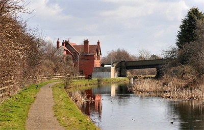 |
Cookson's Bridge, Litherland The Leeds and Liverpool Canal here runs past Rimrose Valley Country Park, a wedge of open grassland, copses and wetland dividing Great Crosby and Litherland. |
 |
| Litherland in the Victoria History of the County of Lancaster (1907) Litherland forms an uninteresting [hang on a minute - I was born there after all!] link between the busy environs of Bootle and the more open country towards Sefton township, since there are both dwelling-houses and warehouses, streets, and shops, as well as open spaces. The ancient township, from which Seaforth has now been carved out, [..] was formerly called Down Litherland to distinguish it from the hamlet of Up-Litherland in Aughton. The Diamond Match Factory is the most prominent industry in Litherland. [...] The field names in a map of 1769 show that the Marsh was the district between Rimrose Brook and the shore [...]. The moss occupied the north-eastern part of the township; the moor adjoined it on the borders of Orrell. |
||
| Litherland in Liverpool (1907) by Dixon Scott [...] Litherland, which lies just beyond that raucous Linacre terminus, a few steps nearer to the cemetery at Ford. They are steps that provide an effective study in contrasts. They carry one across a frail little swing-bridge; and whilst one end of the bridge is immersed in that bad-tempered outburst of industrialism, the other shares an atmosphere of positively Quakerish demureness. Mild old Georgian residences, placidly sunning themselves among their groves and lawns, are respectfully waited upon by an irresistible village street of shops and inns and a post office. [...] It is that highly prosaic thing, the Leeds and Liverpool Canal, that has apparently served to keep this idyll unspotted by the world. It curves like a defensive moat between the bird-song and the harsh imbroglio a biscuit's-throw beyond, and upon the frail structure that crosses it not the most reckless electric car in the world would ever dream of venturing. It is the weakness of that bridge that has proved the place's strength. [...] And one day, no doubt, it will quit the pose perforce. Liverpool will 'nab' it, the moat will be stoutly bridged, a troop of electric cars will storm across, and the quiet little gathering among the trees will be rudely broken up and submerged. |
||
| Orrell with Ford in the Victoria History of the County of Lancaster (1907) This township is formed of two detached portions, Orrell to the south and Ford to the north. [...] Orrell occurs comparatively early as a well-defined part of Litherland, [...] called a 'vill' as early as 1310. [...] It is described as a hamlet of Litherland in 1345. Ford [...] touches upon the open country and shares the refreshing sea-breezes which come from the west. [...] The ford from which the place takes its name was perhaps one over the Rimrose Brook, which divides it from Great Crosby. |
||
| Orrell with Ford in Lewis's Topographical Dictionary of England (1848) The township comprises 470 acres, of a light soil, with a red-sandstone substratum; it stands elevated, and has fine views of the sea and the Welsh hills. [...] The air is very salubrious and healthy. |
||
| Netherton in the Victoria History of the County of Lancaster (1907) This township was originally a hamlet of Sefton, but appears to have been recognized as a distinct township as early as 1624, when the county lay was fixed. [...] It is in the heart of flat, agricultural country. The land is principally arable, producing crops of potatoes, wheat, barley, oats, and rye, in a soil which is a mixture of clay and sand. The country is not interesting, for there is nothing picturesque about the scattered farmsteads, and the trees are only large enough to give a slight protection to the buildings around which they cluster. |
||