|
|
|||||||||
|
|
|||||||||
Home Page: merseySights  |
Home Page: allertonOak  |
|||
 |
| CLICK A BOOTPRINT FOR A RELEVANT WALK - LINKS TO OTHER SITES AT THE BOTTOM OF THE PAGE |
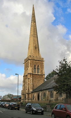 |
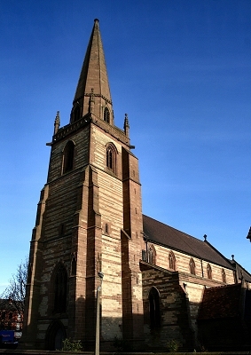
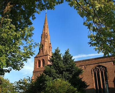
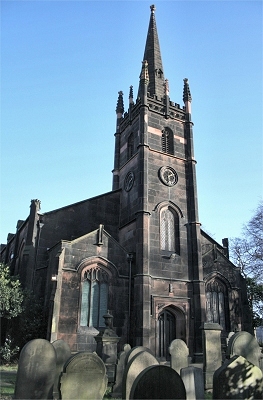
The Church of St. John the Divine, Fairfield The elegant Gothic spire of the church of St. John the Divine in Fairfield, dating from 1853, will be a familiar landmark to those entering Liverpool from the east as it rises above the houses to the north of Edge Lane. It has been under threat of demolition, but appears to have been saved for the time being. |
|
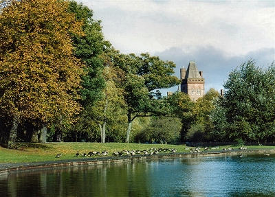 |
Newsham Park, Fairfield Fairfield was a new and fashionable suburb in the mid-18th century and many of the small villas survive. This was Liverpool's first public park (Princes Park was initially private), dating from 1846 and developed from an estate owned by the Molyneux family. The imposing Royal Liverpool Seamen's Orphan Institution completed in 1875, looms over the trees. Iit was designed by Alfred Waterhouse in a Gothic style. It became a hospital after 1949. |
|
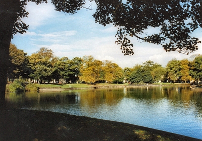 |
Newsham Park, Fairfield | |
 |
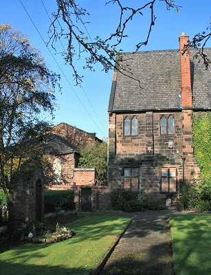
The Church of St John the Baptist, Tuebrook The Parish Church of St John the Baptist was built in 1867-70 to the design of G.F. Bodley, 'large, unshowy, but dignified and sensitive' according to the Pevsner Guide, and a Grade I listed building to boot. |
|
 |
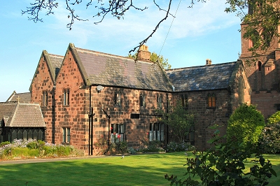
Tuebrook House, Tuebrook Tue Brook once had its source about half way along Green Lane in the district now known as Tuebrook. The Jacobean Tue Brook House, dated 1615, is near here and is the oldest dated house and one of the oldest inhabited properties in Liverpool. Tue Brook made its way north towards the lake in Larkhill Estate Gardens, Clubmoor, and then toward the recreation ground on Townsend Lane. It then followed a route that is still relatively undeveloped along the west side of Kelly Drive and the northern edge of Walton Hall Park to the lake there, and then north to the recreation ground near Rice Lane Station and across to the railway bridge on Long Lane. Here in Fazakerley it makes its first present day appearance, flowing east (and currently renamed Fazakerley Brook) to join the River Alt at the bvery edge of the conurbation. |
|
| Tuebrook in Lewis's Topographical Dictionary of England (1848) This locality, from its elevated situation and the salubrity of the air, is chiefly inhabited by Liverpool merchants, whose numerous mansions and villas adorn the scenery. Tue-Brook Villa is an elegant building in the Italian style; it is appropriated to insane persons of the wealthy classes. Here is a powerful steam-engine connected with the Green-Lane Waterworks, which partly supply the town of Liverpool. |
||
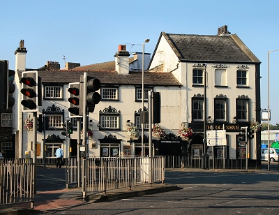 |
The Old Swan, Old Swan Old Swan was an important stop-off on the old coaching route from Liverpool to Prescot. The first pub here was called The Three Swans from the coat of arms of the local aristocratic Walton family. Shortly after, two further Swan Inns were built, referred to by the locals as The Old Swan, The Middle Swan and The Lower Swan. Eventually the whole area became known as Old Swan. The present Old Swan pub is the oldest remaining of the original pubs. The oldest part (I would guess that on the left) is 18th century and the extension was carried out in the 19th century. On the opposite corner a pub called The Red House stands on the site of the original Three Swans coaching house, which is marked as The Old Swan Hotel on the 1891 map. The plan of this building remains the same on the 1893 map but has assumed its present form on the 1908 map. I have read that the Red House was built in 1892, so the 1893 map may be based upon a slightly earlier survey. |
|
 |
St. Oswald's Church, Old Swan Only the red sandstone steeple remains of the original St. Oswalds Catholic church of 1840-2 designed by A.W.N. Pugin. The presbytery to the south side is later (1857). The remainder of the church was completely rebuilt in brick in 1951-7 by Adrian Gilbert Scott of the famous architectural dynasty. |
|
 |
The Convent of Mercy, Old Swan The Convent of Mercy forms part of the picturesque group of buildings to the south of St. Oswald's church designed by A.W.N. Pugin to evoke his ideal of a mediaeval Christian community. Nuns moved in here in 1845 just before its completion. |
|
 |
St. Oswalds Schoolhouse, Old Swan This is one of three buildings in the group of buildings to the south of St. Oswald's church that were originally schoolhouses, probably designed by A.W.N. Pugin in the 1840s. They all now appear to be incorporated into the Convent of Mercy. |
|
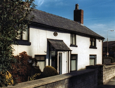 |
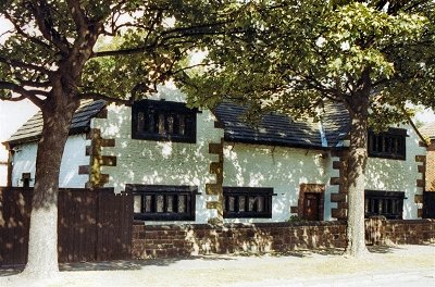
Moss Cottage, Stoneycroft Another old property, dated 1642, swallowed by Liverpool's expansion but retaining its period character. |
|
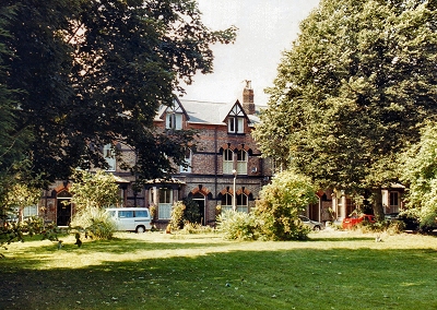 |
Derwent Square, Stoneycroft Derwent Square, a conservation area in Stoneycroft, is one of those corners of Liverpool where, but for the presence of cars, you seem to step back in time. Old Victorian houses fronted by unrestored roads surround a tranquil square of grass and mature trees. |
|
 |
The Church of St.John the Evangelist, Knotty Ash This fine, elegant church, constructed from local West Derby and Woolton sandstone, was built in 1836. It is located in the conservation area of Knotty Ash village, a peaceful enclave seemingly far removed from the busy highways that surround it. The church was extended during the 19th century and the stained glass windows are particulary noteworthy, including one by Edward Burne-Jones and William Morris. There is a bell of 1707 from St. Peter's Church (once of Church Street, Liverpool). |
|
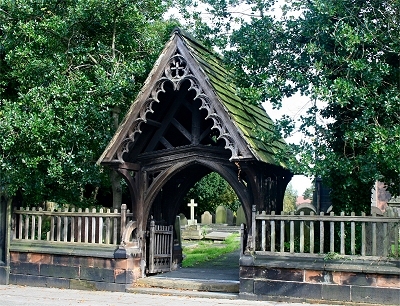 |
Lych Gate at the Church of St.John the Evangelist, Knotty Ash This impressive lych gate dates from 1900. It was constructed from oak timbers rescued from the demolition in 1897 of Boltons, then the oldest house in West Derby (built around 1400) and incorporates features of the original woodwork. |
|
| Knotty Ash in Lewis's Topographical Dictionary of England (1848) The situation of this locality is very beautiful, and its air salubrious; it contains several handsome mansions, and some of the principal merchants of Liverpool have seats and villas here. |
||
| Knotty Ash in Liverpool (1907) by Dixon Scott [...] Knotty Ash [...] a jolly stage-setting of taverns with farm-carts before them, of tiny, twinkling pinafores pouring out of a village school, of a neat spire [...] rising above a grove of realistic trees [presumably St.John the Evangelist]. |
||
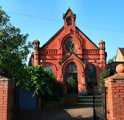 |
Congregational Church, Knotty Ash The old Congregational church on Thomas Lane, a pretty building in vivid red brick, probably dates from the late 19th century. It currently appears to be residential. |
|
 |
Old houses, Prescot Road, Knotty Ash These old houses are a reminder of the Knotty ash of 200 years ago amid the 21st century hustle and bustle of Prescot Road. |
|
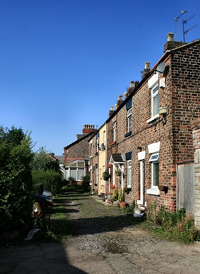 |
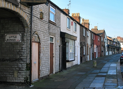
Old Houses in Little Bongs, Knotty Ash These probably 18th century houses are tucked away on Little Bongs, a street of sorts opening through an archway on Prescot Road. You would never guess they were there! |
|
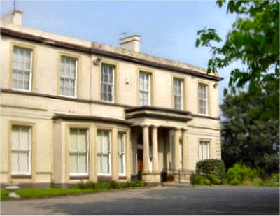 |
Thingwall Hall Thingwall was an ancient township that has now lost its identity, having been subsumed into Knotty Ash. Even in the mid-19th Century there was little here except for the manor house known as Thingwall Hall and Thingwall Farm. We still have the hall and the original road, Thingwall Lane. Thingwall Hall is an 18th century house, called Summer Hill on the Yates and Perry map of 1768, that was extended around 1790 and remodelled by Harvey Lonsdale Elmes (of St. Georges Hall fame) in 1846-7. However Thingwall is Old Norse for assembly field and the small 175 ft (53 m) high hill was a major meeting place or parliament for Viking communities (who had begun to settle here in the early 10th century) from the entire region. A large number of Vikings had settled peacefully in the newly founded Viking kingdom of Dublin and some became Christianised by the native Irish. However they were expelled from Ireland beginning in 902 by Caerbhall, leader of the Leinster Irish, and continuing until 1014 with the Battle of Clontarf. The coastal regions of south-west Lancashire were at that time poor quality land, largely uninhabited, and hence undisputed by, the locals. Scandinavian culture became dominant in the area until the Norman conquest (Frenchified Vikings). The local language would have merged with that of the settlers, but would have had a predominantly Scandinavian character. This is a freely licensed image courtesy of Wikipedia Commons. |
|
| The Trans-Pennine Trail near Knotty Ash The Trans-Pennine Trail here follows the old Cheshire Lines railway line (the Liverpool Loop Line) that passes through the eastern suburbs of Liverpool and once connected Hunts Cross to the north docks (via Walton on the Hill) and Southport (via Aintree Central). Other stations were Gateacre and Woolton, Knotty Ash and West Derby and Clubmoor. Not much remains of these except at West Derby. Passenger services ceased in 1960. It is hard to imagine steam trains running here so recently. Despite the proximity of habitation, there is a sense of isolation, peace and quiet all along the track. Near Knotty ash, it cuts through sandstone bedrock. Elsewhere it is surrounded by trees. |
 |
|
| LINKS |
| Newsham Park at liverpool.gov.uk |
| Old Swan by Tom Armstrong |
| St. Oswald's Church website |
| St. John's Church Tuebrook website |
| The Trans-Pennine Trail website |
| Welcome to Thingwall |