|
|
|||||||||
|
|
|||||||||
Home Page: merseySights  |
Home Page: allertonOak  |
|||
 |
| CLICK A BOOTPRINT FOR A RELEVANT WALK - LINKS TO OTHER SITES AT THE BOTTOM OF THE PAGE |
 |
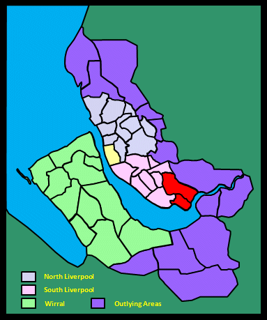
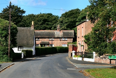
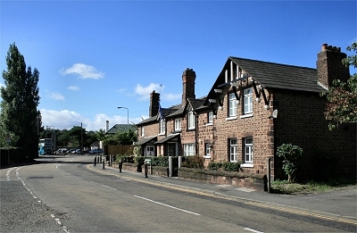
Hale High Street The village of Hale dates from Saxon times. It is still an attractive and tranquil place with many old whitewashed cottages. |
 |
| Hale in Lewis's Topographical Dictionary of England (1848) Among the families connected with this place have been the Waltons, Hollands, Irelands, and Blackburnes: Sir John de Hibernia, ancestor of the Irelands, came over with the Conqueror, and was buried at Hale chapel in 1088. The township is beautifully situated on the northern bank of the river Mersey; it forms the most southern point of land in Lancashire, and comprises 1626 acres. The village is a delightful spot, and one of the most ancient villages in the county: it received a charter from John, of a market and a fair. The Hall, the seat of John Ireland Blackburne, Esq., who is lord of the manor, is a very ancient mansion of brick, with stone ornaments, and a great part of it is covered with ivy: the north front was built in 1674 by Sir Gilbert Ireland; the south front was rebuilt in 1809, from designs by Nash. |
||
| Hale in the Victoria History of the County of Lancaster (1907) Hale is a riverside township, the southern and eastern limits being washed by the Mersey, which curves round Hale Point, the most southerly land in the county, whereon stands a lighthouse. The northern boundary is mainly formed by Rams Brook. The land is flat, interspersed with plantations and farms; rows of straight, tall Lombardy poplars being noticeable features of the open landscape. The park and grounds of Hale Hall occupy a large portion of the river frontage. The village of Hale is a straggling one, with some pretty cottages set in flowery gardens. The surrounding country is entirely agricultural. Crops of barley, wheat, and turnips are grown, on loamy and sandy soil with a mixture of clay. It is said to be one of the best wheat-growing districts in Lancashire. To the north is the hamlet of Ciss Green [what hamlet and where?], and at the western corner, on the banks of the Mersey, is [the] Dungeon, where a century ago there were considerable salt works, long since discontinued. The village is much frequented in summer by pleasure parties. [...] The highest ground is but little over 80 ft.; the lowest is in the Decoy Marsh, so called from a decoy for wild fowl formed near Hale Point. [...] A ferry from Hale to Runcorn was established at an early period. It had been discontinued for want of a boat for two years in the time of King John [...]. Formerly there was a ford in general use. John Walley of Runcorn in 1423, in attempting to ride across to Weston by it with two horses laden with fish from Formby, was drowned, though the fish-laden horses crossed safely. In 1465 the court rolls record that a certain John Jackson of the north country and some companions crossed by it with horses, cattle, and sheep, and were stopped by the bailiff until they paid the toll called 'stallage'. The ford was in constant use in the Civil War period and later, being mentioned in the deeds of the Halsall charity bequest in 1734. In the early part of the last [19th] century a fair for toys and pedlery was held on 19 November, when a large number of persons called freemen, chosen by the manor court, appointed a mayor. A wake was held on the Sunday next to 15 August. [...] he lord had a toll (4d [pence]) from every vessel casting anchor within the bounds. It was the duty of the water bailiff to collect this due or to make distraint for it. From the old court rolls it appears that money found on a drowned man brought ashore at Hale, like other things cast up by the river, went to the lord as 'dower of the sea'. |
||
 |
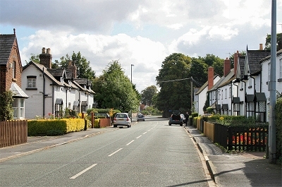
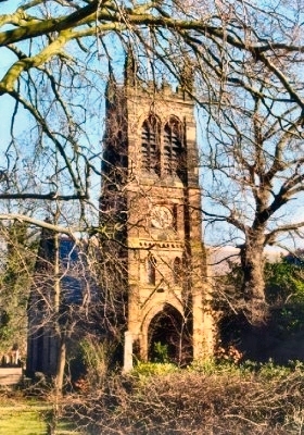
St. Mary's Church, Hale St. Mary's church stands on the site of an earlier church dating back to 1081. The present church dates from 1758-9, though the tower is 14th century. It was rebuilt internally in 1981 following a fire in 1977, which revealed the foundations of an earlier, narrower, timber-framed church. |
|
 |
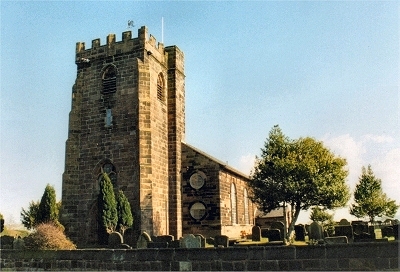
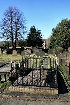
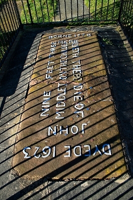
Tree Carving of John Middleton, the Childe of Hale The graveyard of St. Mary's contains the tomb of local celebrity John Middleton (1578-1623), the Childe of Hale, easily spotted by being surrounded by railings. We are informed on the tomb that he was 9 ft 3 in (2.8 m) tall, though curiously the tomb is only 6 ft (1.8 m) long. If you look up over his tomb, you will see him as in the picture, serenely and surreally gazing back, carved life-size from a dead beech trunk and holding a lighthouse; the carving, called the History Tree, was created in 1996 and is adorned in images of the village and its history. The local lord, Gilbert Ireland, is said to have employed the Childe as a minder. On being awarded a knighthood, he took Middleton to London with him where he trounced King James's favourite wrestler. Evidently not being one to bear grudges, the King gave him a prize of £20 but, being a simple soul, Middleton allowed himself to be separated from his winnings by his more streetwise travelling companions. His portrait, wearing his posh London gear, is in Speke Hall. |
|
 |
John Middleton's Tomb, Hale | |
 |
John Middleton's Tomb, Hale | |
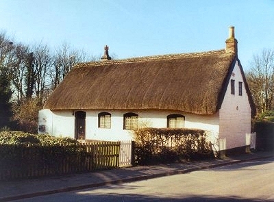 |
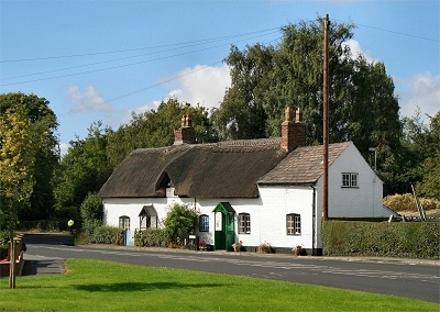
John Middleton's Cottage, Hale This lovely 17th century cottage is where John Middleton is thought to have lived, though you may be left wondering how he managed to get in through the door. |
|
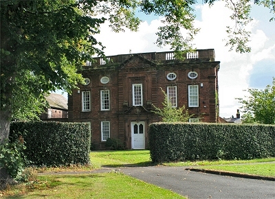 |
The Manor House, Hale The Manor House was originally the parsonage. It has its origins in the early 17th century but was partially rebuilt, including the lavish façade, by the then vicar in ca. 1705. Parts of the original structure remain at the rear. |
|
 |
Church End, Hale Church End, with its 17th century cottages, is one of the prettiest parts of the village. |
|
 |
Cottage, Hale | |
 |
View from Within Way, Hale | |
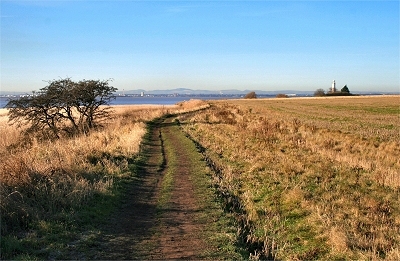 |
The Mersey Way heading for Hale Head Lighthouse | |
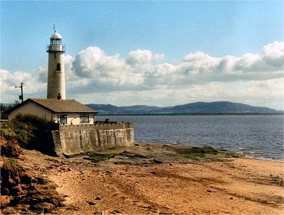 |
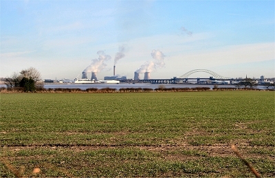
Hale Head Lighthouse Hale Head Lighthouse (once known as the Dungeon Light), to the south east of Liverpool at the southernmost point in Lancashire, was built on the site of an earlier octagonal lighthouse dating from 1838. The present round tower was completed in 1907. During the Second World War, the light attracted the attention of enemy aircraft, and bombs were dropped in the vicinity. In one incident, the keeper's wife was machine gunned from the air as she was opening the lighthouse shutters. The lighthouse was decommissioned in 1958 and is now a private residence. The lenses are in the Merseyside Maritime Museum. The widest part of the Mersey estuary is around here. The water is deserted now, though only a 100 years ago it was busy with shipping supplying the industries up-river. |
|
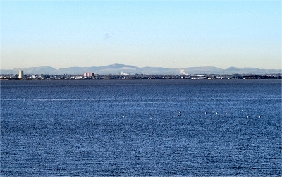 |
The Mersey Estuary and the Clwydian Hills from Hale Head | |
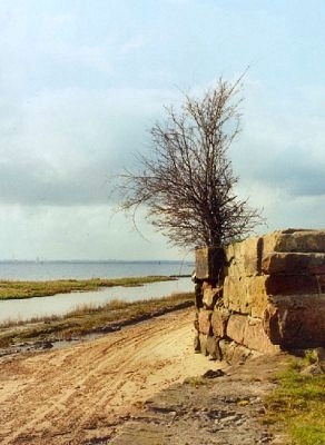 |
The Old Dungeon Quay, near Hale The Dungeon is a tiny bay on the bank of the Mersey near Hale, where there are the remains of a late 17th century salt refinery. It was later a shipbreaking yard. There is also a substantial sandstone wharf. |
|
 |
St. Nicholas's Church, Halewood The original very simple structure of St. Nicholas's church of 1838-9 has been greatly modified over many years. The tower was added in 1882-3. A particular feature of the church are the 17 stained glass windows designed and produced by William Morris and Edward Burne-Jones between 1874 and 1892. |
|
| Halewood in Lewis's Topographical Dictionary of England (1848) It comprises [...] generally level surface, and for the most part good strong corn-land, which has been much improved by drainage and the application of manure. [...] An antiquated and secluded building here, called The Hutte, or The Haut, was the abode of the Ireland family, lords of the place, who subsequently removed to Hale Hall. [...] The church [in Hough Green?], dedicated to St. Michael, was built in 1839, at a cost of £1200, and was enlarged in 1847, at a cost of £900; it is a cruciform structure in the early English style, with a very neat interior. |
||
| Halewood in the Victoria History of the County of Lancaster (1907) This township lies between the old course of the Ditton Brook on the north and Rams Brook on the south, both running into the Mersey. Halewood Green, with a hamlet called North End, is near the northern boundary. To the south-east of this is the village. The part of the township bordering on the Mersey is called Halebank, in which is the site of a large moated house called Lovel's Hall. The country is bare and flat, with wide, open fields, principally cultivated, yielding crops of barley, oats, wheat, and root crops such as turnips and mangel-wurzels. Several wide main roads traverse the country in every direction, much appreciated by the cyclist and motorist. There are very few trees, but good substantial hawthorn hedges, especially about the farmsteads. On the Mersey bank is a fringe of flat marshy fields and mud banks. Houses and farms are very much scattered. [...] On sinking a well near Ditton Junction station in 1881 some Roman remains were found. |
||
 |
Halewood Village Halewood means simply 'Hale's wood', connecting it with nearby Hale, of which it was originally a part but had a separate existence by the 15th century. The remains of the original village abut the post-war suburban sprawl of south-east Liverpool on one side and tranquil countryside on the other. |
|
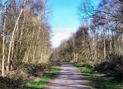 |
Halewood Triangle Country Park The park opened in 1986 on land purchased following the closure of the Cheshire Lines Railway. It is one of Merseyside's few remaining native woodland areas. |
|
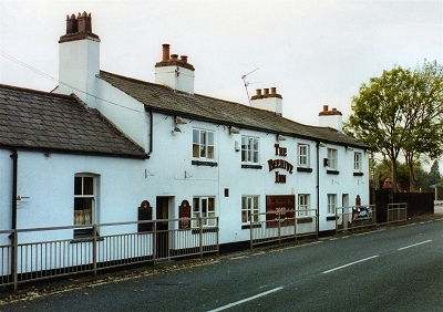 |
The Beehive Inn, Hale Bank This 300 year old inn on Halebank Road retains much of its old character. |
|