|
|
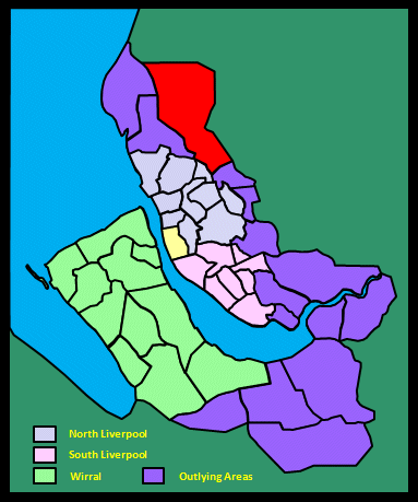
|||||||||
|
|
|||||||||
Home Page: merseySights  |
Home Page: allertonOak  |
|||
 |
| CLICK A BOOTPRINT FOR A RELEVANT WALK - LINKS TO OTHER SITES AT THE BOTTOM OF THE PAGE |
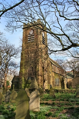 |
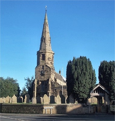
St. Andrew's Church, Maghull The present church of St. Andrew dates from 1880, replacing a much older church, the remains of which stand in the graveyard. |
 |
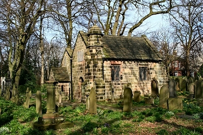 |
The Ancient Chapel of Maghull This is all that remains (the chancel and the north-aisle chapel or Lady Chapel) of the early 13th century church, now known as the Ancient Chapel of Maghull, in the grounds of the present St. Andrew's church. It was modified and extended significantly in 1755 and again in 1830. This later work was demolished when work began on the new church in 1878 and some of the stone was reused for the porch; the west and south walls of the chapel were rebuilt to provide a completed building and the roof was relaid with the original slates. It is the oldest ecclesiastical building still in constant religious use on Merseyside. There are other old buildings in the area, including a stone-built house dated 1660 on the opposite side of the road. |
|
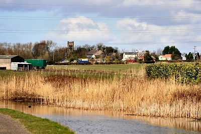
| Maghull in the Victoria History of the County of Lancaster (1907) In the xv cent. the name was contracted to Maile or Male, which shows the local pronunciation [not any more - stress on the second syllable and no 'h']. Sometimes the article was prefixed, 'The Maile'. Maghull is an agricultural township, situated in flat country fairly well supplied with trees, generally grouped about the villages and farmsteads. The land is divided into arable and pasture, the latter mostly to the west, whilst numerous market gardens thrive on a light sandy soil. Crops of potatoes and other root crops, wheat and oats are successfully cultivated. The Leeds and Liverpool Canal crosses the township from north to south-east; the upper end of Maghull village, with its sett-laid roads and gaily painted houses, is a typical canal-side settlement. |
||
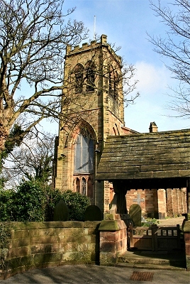 |
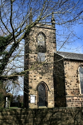
The Church of St. Thomas and the Holy Rood, Melling The original hamlet of Melling stands isolated on an outcrop of sandstone elevated above the flat surrounding countryside. The present church of St. Thomas and the Holy Rood was built in 1835. It replaced an earlier church of the Holy Rood dating from about 1195. |
|
| Melling cum Cunscough in Lewis's Topographical Dictionary of England (1848) The chapelry comprises [...] is elevated, and from the churchyard is a complete panoramic view, including Liverpool, and, in the distance, the Welsh mountains. The church, St. Thomas's, was rebuilt on a new site in 1834 [...]; it is in the early English style, and forms, from its elevated situation, a conspicuous object in the scenery. |
||
| Melling in the Victoria History of the County of Lancaster (1907) This township [consists of] Melling proper or the south-western half, and [...] Cunscough [no longer a distinct place, though there's a lane, a brook and a hall] in the north-east. The ground rises gradually from the Alt, the western boundary, towards the north-east, reaching 120 ft. near the centre of the township, where is the hamlet of Melling Mount. The hamlet of Waddicar is to the east of Melling village. The church and its few attendant buildings stand upon a slightly elevated knoll of sandstone rock, whence the surrounding country appears in a level panorama. Fields of corn, potatoes, and varied market-garden produce make patches of different colours on every hand, whilst trees and bushes are of the scantiest description. The country in the northern portion of the district is rather richer in appearance; there are a few more trees than in the south. [...] There are stone pottery works and a gun-cotton factory. |
||
 |
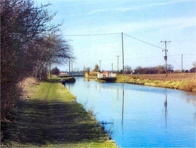
Melling Village from the Leeds and Liverpool Canal | |
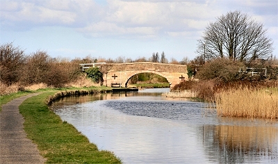 |
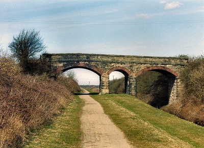
Melling Stone Bridge, near Melling | |
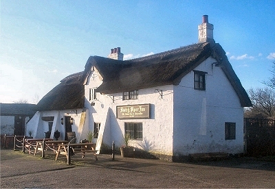 |
The Scotch Piper, Lydiate The Scotch Piper on Southport Road (A5147) is reputedly the oldest pub in Lancashire and is still very much in its original form. Now thought to date from the reign of Elizabeth I in the mid-16th century, during the lifetime of Lawrence Ireland II of Lydiate (died 1566, great-grandson of Lawrence I of St. Catherine's Chapel), it is not quite as old as is often said. Legend has it that the name commemorates an event during the Jacobite Rebellion of 1745 when a wounded Scottish piper took refuge at the inn, fell in love with the inn-keeper's daughter and married her. Prior to then, it is thought to have been called the Royal Oak. It has probably been a pub since the mid-17th century. Until quite recently, the beer was still served in the old way, drawn under gravity from barrels and served from jugs. I remember Sunday lunchtime trips out here when I was a kid in the 1950s, when I was allowed a bottle of Cherry B outside in the car until the day my parents found out it was quite high in alcohol. It explains a lot! |
|
| Lydiate in Lewis's Topographical Dictionary of England (1848) The soil is in a high state of cultivation, from the abundant supply of excellent town manure. The surface is generally flat, broken occasionally by eminences affording extensive views of the valley between the Ribble and the Dee, and of the bold mountainous range of North Wales, with the shipping in the offing of the Mersey. [...] Lydiate Hall was built, or, more properly, renewed, in the 16th century, though portions of it indicate a later date; it was of quadrangular form, but the front, becoming greatly dilapidated, was taken down about seventy years ago. The interior presents several objects of interest to the antiquary, ancient sculptured effigies of saints and martyrs, carved oak, richly-traced cornices, and other details; the upper rooms of the central part have been thrown into one, now used as a Roman Catholic chapel, and it is said that ever since the Reformation the Roman Catholics of the district have resorted to the Hall for the exercise of religious worship. [...] Here is a picturesque little ruined chapel, erroneously called by the people Lydiate Abbey, erected in the latter part of the 15th or beginning of the 16th century; it seems to have been originally intended for the convenience of the family and immediate neighbourhood, owing to the distance of the parish church. The tower is in tolerably good preservation, but the roof of the building has entirely disappeared. |
||
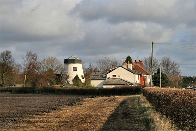
| Lydiate in the Victoria History of the County of Lancaster (1907) Lydiate proper is bounded on the south by small brooks which divide it from Maghull, and on the east and north by the Sudell or Lydiate Brook; while on the west the 25 ft. level is almost coincident with the boundary. The township also includes the ancient Eggergarth, to the north of the Sudell Brook, and forming a wedge between Aughton and Downholland. [...] The highest point in Lydiate is near the southern boundary, where the windmill stands, about 87 ft. above sea level; Eggergarth rises to 80 ft. on the northern boundary. The country is chiefly agricultural, occupied by market gardens and fields, where potatoes and cabbages alternate with wheat and oats. |
||
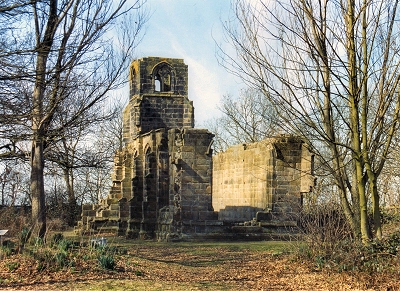 |
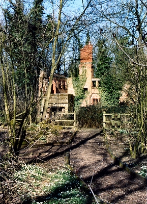
St Catherine's Chapel, Lydiate The chapel was built for the Ireland family, lords of the manor of Lydiate for 400 years, in the late 15th century. The work was begun by Lawrence Ireland I who married Catherine Blundell of Little Crosby; the chapel is dedicated to her name-saint. It suffered damage during the Dissolution of the Monasteries (1536-40) but continued to be used in secret by Roman Catholic recusants, who put up a strong resistance in this area. This haunting ruin among the trees held a sombre fascination for me as a child, when I joined others, including Lawrence and Catherine, in carving my initials in the stonework. More recently it has brought to mind an atmospheric painting by Caspar David Friedrich called 'The Abbey in the Oak Wood'. I'm blowed if I can find my initials though. |
|
 |
Ruins of Lydiate Hall, Lydiate Lydiate Hall, seat of the Ireland family, probably dates originally from mediaeval times. The present ruins are all that remains of a 15-16th century house that was once a quadrangular structure like Speke Hall. Lydiate Hall Farm, adjoining it to the north, dates from 1744. The ruins lie in pleasant woodland laid out with paths. |
|
 |
Lydiate Hill Bridge, Leeds and Liverpool Canal, Lydiate | |
 |
Forest's Mill, Lydiate Forest's Mill, sometimes known as Foster's Mill, was built in 1768. It was derelict for a long time and was converted into a house in the 1960s. |
|
 |
Our Lady's Church, Lydiate The church of Our Lady was built in 1856, providing a catholic church in Lydiate for the first time since St. Catherine's Chapel was destroyed during the Dissolution of the Monasteries (1536-40). There was originally a steeple above the tower, but this was found to be unsafe in the 1950's and was dismantled. Part of the reredos from the original altar in the Chapel can be seen in the present church. |
|
 |
St. Thomas's Church, Lydiate St. Thomas's church, in an isolated rural setting, was built in 1841 to serve the local farming community of Lydiate, Haskayne and Downholland, some of whom had previously to walk up to 6 miles (10 km) to attend services at Halsall or Maghull. The stone came from a quarry in Aughton and was carted by 61 local farmers who were presented with a medal for their services. A new chancel was completed in 1912. |
|
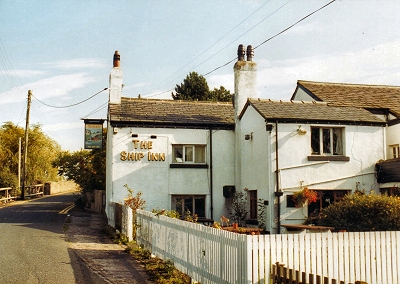 |
The Ship Inn, Haskayne A cosy, characterful pub located on the Leeds and Liverpool Canal at Haskayne. It is located on Rosemary Lane, off the A5147. |
|
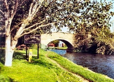 |
The Ship Inn, Haskayne An added attraction of the Ship Inn is the delightful back garden right on the Leeds and Liverpool Canal towpath. |
|
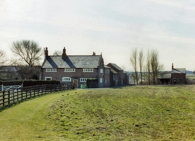 |
Downholland Hall, Downholland The lords of the manor here are documented back to the time of Edward the Confessor. The present Downholland Hall bears the date 1729. |
|
| Downholland in Lewis's Topographical Dictionary of England (1848) Down-Holland Hall, anciently a 'a post and patrel' dwelling, contained much massive timber; it is now a farmhouse. [...] The Leeds and Liverpool canal flows close to the village. Here are two hamlets, Haskayne, which gave name to a reputable family who resided on the spot; and Barton, where is a remarkable salt-water spring, of which the old geographer, Bowers, says: 'this fountain of salt water must proceed from some rock of salt, and not from the sea, because it has been demonstrated that a quart of salt-water will yield but an ounce and a half of salt, whereas the same quantity of this spring produces near half a pound of good white granulated salt.' |
||
| Downholland in the Victoria History of the County of Lancaster (1907) This is a composite township, Barton in early times having been separate. It lies on a very gradual slope from a slight ridge reaching 70 ft. above sea level down to fenland only 11 ft. above that level. The three villages, Downholland, Haskayne, and Barton are situated on the higher ground. The lower ground is of a marshy character, but mostly reclaimed and converted into fertile fields, drained by ditches in the lower parts and divided by spare hawthorn hedges in the higher portions of the township. There is a natural dearth of plantations and hedgerow trees in a district swept continually by sea-breezes, and what trees there are are stunted and bent by the prevalent westerly winds, whilst the many picturesque thatched cottages in the villages also seem to turn their backs to the west. The principal crops produced in the township, grown on the sandy soil, are potatoes, cabbages, wheat, and oats. [...] The Leeds and Liverpool Canal winds through the township, crossing the main road at Downholland and Haskayne; it is the principal means of carriage for the farm produce of the district. The Cheshire Lines Committee's railway crosses the mosslands north, and has a station called Mossbridge. Just at the southern boundary there is a junction with the branch line of the Liverpool, Southport and Preston Junction Railway, which has a station at Barton village. [...] Near this village there was 'a remarkable fountain of salt water', a quart producing 'near half a pound of good white granulated salt'. There is abundance of brine under Barton Moss, but though a company was formed to pump it, nothing was done. An amphora of Samian ware [Roman] was found here in 1712. |
||
 |
Downholland Swingbridge, Leeds and Liverpool Canal, Downholland | |
 |
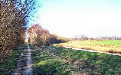
The Cheshire Lines Path, Downholland This path, part of the Trans-Pennine Trail, follows the route of the old Cheshire Lines railway. The line was opened in 1884 to exploit the burgeoning tourist trade to Southport but was never really competitive with the more direct route from Liverpool Exchange Station (the current service) and it finally closed in 1952. The stations used to be: Aintree Central, Southport Junction, Sefton and Maghull, Lydiate, Altcar and Hill House, Mossbridge, Woodvale, Ainsdale, Birkdale and Southport Lord Street. Today it's a splendid walking and cycling track across the wide open spaces of the mosses. |
|
 |
Barton Spur Barton Spur is a woodland conservation area on the Cheshire Lines Path. It is named after the branch line that used to head off to the right here towards Barton. The route is still clearly visible though not accessible to the public. |
|
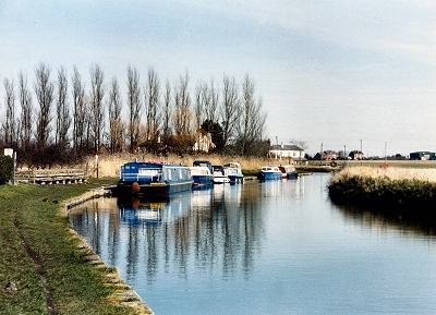 |
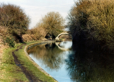
Leeds and Liverpool Canal at Haskayne The canal came to this area north of Liverpool in the years following 1770 and had a dramatic effect on the local population. The large number of navvies (the canals used to be known as navigations) stimulated trade and, it ought to be mentioned, procreation. Transport of coal from Wigan to Liverpool was the initial driving force for its construction, but it was quickly used for all sorts of cargo, including holiday-makers on their way to Southport. Previously, access to the area had been difficult because of the flooding of the surrounding mosses (the flood plain of the River Alt), and the canal represented a huge improvement. Local farmers were now more easily able to get their produce to the markets in Wigan and Liverpool and bring back manure from horses (and humans!) for fertiliser. |
|
 |
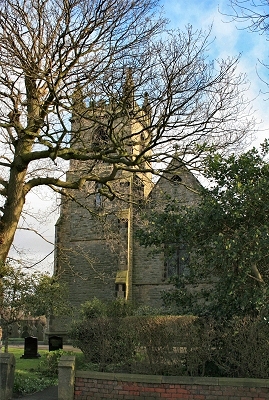
St. Cuthbert's Church, Halsall Halsall was recorded in the Domesday Book, when it was one of the principal manors in the district. The village used to sit at the edge of a great moss that spread out to the west and became flooded in winter. Like much of the neighbouring area, the land has now been drained and is fertile crop growing territory. The church of St. Cuthbert dates from about 1320, probably replacing an earlier church, and stands on slightly higher ground, along with most of the older habitations. The 126 ft (38 m) tower and spire were added in about 1400, though the present spire is a more recent replacement. The Leeds and Liverpool Canal passes behind the village and, indeed, the first excavations took place here in 1770. |
|
| Halsall in Lewis's Topographical Dictionary of England (1848) It is situated near the coast, and intersected by the Leeds and Liverpool canal, which passes through each of its townships; the views of the sea are good, and the air salubrious. There are some quarries of freestone; and in Halsall moss, which is rather extensive, is found a bituminous turf, which burns like a candle. The parochial church is handsome, partly in the decorated and partly in the later English style, with a lofty spire, and forms a conspicuous object in the scenery. |
||
| Halsall in the Victoria History of the County of Lancaster (1907) This township had formerly a great moss on the west, covering about half the surface, and constituting an effectual boundary. Down to recent times there were also three large meres - Black Otter, White Otter, and Gettern. The fenland has now been reclaimed and converted into fertile fields under a mixed cultivation - corn, root crops, fodder, and hay. There is some pasture land, and occasional osier beds fill up odd corners. The soil is loamy, with clay beneath. The low-lying ground is apt to become flooded after wet weather or in winter-time, and deep ditches are necessary to carry away superfluous water. In summer these ditches are filled with a luxuriant fenland flora, which thus finds shelter in an exposed country. The scanty trees show by their inclination the prevalence of winds from the west laden with salt. The ground rises gently to the east; until on the boundary 95 ft. is reached. [...] The Liverpool, Southport, and Preston Junction Railway, now taken over by the Lancashire and Yorkshire Company, formed a branch through the township with a station called Halsall, half a mile west of the church, and another at Shirdley Hill. The scattered houses of the village stand on the higher ground near the church. To the south-east is the hamlet of Bangors Green; Four Lane Ends is to the north-east. From near the church an extensive and comprehensive view of the surrounding county is obtained. The northern arm of the Downholland Brook rises in and drains part of the district, running eventually into the River Alt, which is the natural receptacle for all the streams and ditches hereabouts. The Leeds and Liverpool Canal crosses the southeastern portion of the township, with the usual accompaniment of sett-laid roads and untidy wharfs. [...] The hall is to the south-west of the church; between them was a water-mill, taken down about 1880. North-east of the church are portions of the old rectory house, consisting of a wall 55 ft. long, with three doorways and three two-light windows, several traces of cross walls, and a turret at the north-west. Part is of fourteenth-century date. |
||
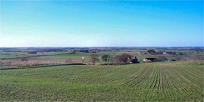 |
The Mosses from Clieves Hills The term 'hills' here is to be understood in a relative sense. The summit of Clieve's Hills near Aughton, such as it is, is 184ft (56m) above sea level, but the South West Lancashire Mosses to the west are so flat and low lying that the view is extensive. It extends from the Liverpool skyline to the south to Blackpool tower to the north, via the Clwydian Hills and the mountains of Snowdonia in Wales, the Formby and Ainsdale pinewoods, and Southport. |
|