|
|
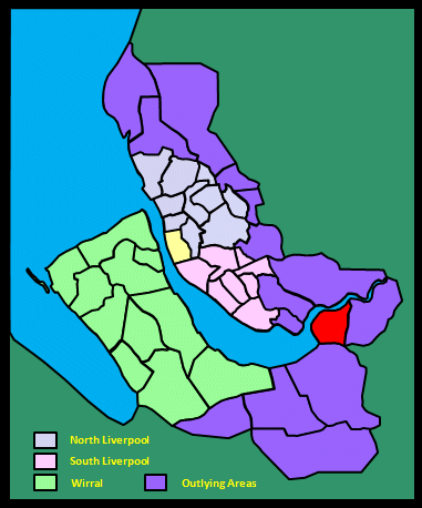
|||||||||
|
|
|||||||||
Home Page: merseySights  |
Home Page: allertonOak  |
|||
 |
| CLICK A BOOTPRINT FOR A RELEVANT WALK - LINKS TO OTHER SITES AT THE BOTTOM OF THE PAGE |
 |
The Runcorn Bridges from the Promenade, Runcorn Runcorn first gets a mention in history when King Alfred's daughter Princess Aethelfreda visited in the year 916 to inspect a fort on the riverside here at Runcorn Gap (she was much concerned with retrieving land from the Danes) and, legend has it, to found the first church where the present parish church now stands. There has been a ferry at Runcorn Gap on the River Mersey since at least the 12th century. The area remained of strategic importance throughout mediaeval times, Halton Castle being constructed in the late 12th century. Runcorn was a prosperous market town at this time but appears to have gone into a decline and by the mid-17th century was 'nothing but a fair parish church, a parsonage and a few scattered tenements'. This all began to change with the arrival of the Bridgewater Canal in 1776 and the growth of sandstone quarrying and the chemical industry, the latter largely incorporated in its entirety into ICI in 1926. |
|
| Runcorn in Lewis's Topographical Dictionary of England (1848) In the year 915, Ethelfleda, sister to King Edward the Elder, and widow of Ethelred, Earl of Mercia, built near the Mersey a town and castle, called Runcofan, some traces of which are still visible at Castle-Rock, by the river side, about 300 yards below the church of Runcorn. The head of the rock once extended much beyond its present limits, jutting a considerable distance into the Mersey, and abruptly contracting the bed of that river: the strait thus formed was called the Gap, a name which the vicinity still bears, though the stream at this point is now about 400 yards broad at high water. The castle commanded the passage from the kingdom of Mercia to that of Northumberland. In 1153, William Fitz-Nigel founded here a monastery of Canons regular; but about the reign of Stephen, the founder's son William, constable of Chester, removed it to Norton, a township in the parish, east of Runcorn. The Town has much increased within the last few years in magnitude and importance. At the time when the Old Quay and the Duke of Bridgewater's canals (both of which pass through a great portion of the parish) were cut, it was a romantic and secluded village; it is now a town of considerable size, with every indication of becoming much larger. Improvements of every description are taking place in the town and neighbourhood; whole streets of houses have been lately built, others are in the process of building, and more are planned. [...] The canals already mentioned, which here form a junction with the Mersey, are the great route by water for goods passing between Liverpool and the eastern and southern parts of the kingdom. The position of Runcorn with respect to the manufacturing districts of Lancashire, Yorkshire, Cheshire, and Derbyshire, the Potteries, and the iron-districts of Wolverhampton, Birmingham, &c., renders the port especially eligible for purposes of traffic; and the coal-fields of Lancashire and salt-works of Cheshire give facilities to ships in procuring cargoes here with the least possible delay, ready and economical communication existing with both the collieries and the salt-works. The Bridgewater canal is 82 feet above the level of the river, with which it communicates by a series of locks. The Old Quay canal is of a much lower level, and joins the Mersey by the aid of a single lock only. The river is navigable to Runcorn by vessels of 350 tons: the class usually seen here are coasters, varying from 20 to 180 tons. Steamers ply daily with the tide between Runcorn and Liverpool, one or more, according to the season, being engaged in the conveyance of passengers, and others in towing vessels: in connexion with the steamers for passengers, and also independently of them at fixed periods of the day, are canal boats to and from Manchester that travel at the rate of ten miles an hour. There is also a ferry across the river, on the other side of which commences the Runcorn-Gap and St. Helen's railway. Runcorn Hill, or the Beetle, as it is provincially termed, and its environs, present an almost inexhaustible supply of stone; and from the quarries opened there and in other parts of the parish, considerable quantities of stone are sent by water to Chester, Liverpool, and Manchester. At Runcorn are also extensive soap and chemical works, in connexion with which are two circular brick chimneys, surmounted by capitals of hewn stone, and forming columns of great beauty. There are several large ship-building establishments by the side of the river; two foundries; and a chain-factory. |
||
| Runcorn in The Beauties of England and Wales, Vol II, Edward Wedlake Brayley and John Britton (1809) Runcorn is situated on the banks of Mersey, which is bere suddenly contracted from a considerable breadth to a narrow channel, by a projecting point of land from the Lancashire side, was originally built by the renowned Ethelfleda, who also erected a castle opposite the gap, as the above strait is denominated, to defend this extremity of her extensive domain. Not a vestige of this building can be seen, but its site is marked by the name of the Castle, given to a triangular piece of land, surrounded with a mound of earth, jutting out into the river, guarded on the water side by ledges of rocks and broken precipices, and cut off from the land by a ditch six yards in width. The parochial church stands above the castle rock; its foundation was probably coeval with the castle, but was certainly prior to the Conquest, since Nigel, Baron of Halton, bestowed it on his brother Wofrith, a priest, at the time of the Conqueror. In the succeeding reigns, the consequence of Runcorn decayed, and it sunk to an obscure village, from which situation it has only emerged since the completion of the Duke of Bridgewater's navigation, which here communicates with the Mersey, descending precipitously through a grand series of all the locks on his canal. These are supplied with water by vast basins or reservoirs and, from the attendance they require, occasion a great conflux of workmen, and the consequent increase of dwelling-houses, inns, shops, &c. A vast warehouse has likewise been erected on a new plan, and various wharfs built for the accommodation of traders. Runcorn has lately become a place of resort for salt-water bathing, the fine air and the pleasantness of the neighbourhood constituting useful auxiliaries to the effects of the bath. In the quarries here, which lie contiguous to the canal, large quantities of free-stone are procured, of a very excellent quality. The shore from this village to Weston Point is protected by a low ridge of rock, rising almost perpendicularly from the beach. |
||
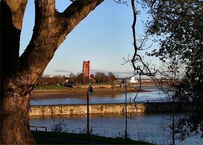 |
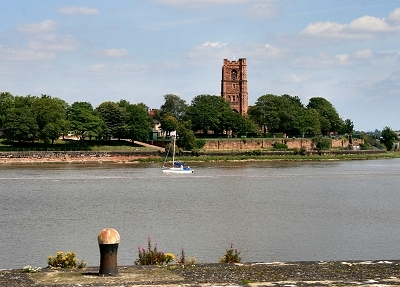
Widnes and the Mersey from Runcorn St. Mary's Church is on the opposite bank of the Mersey, with the Manchester Ship Canal in the foreground. |
|
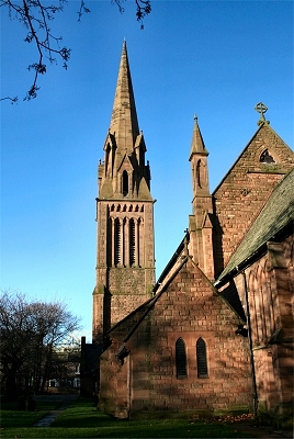 |
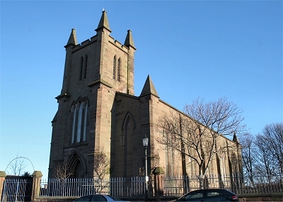
All Saints Church, Runcorn There is a tradition that the first church was founded here in 915 by Ethelfleda when she built a castle nearby. It was dedicated to St Bertelin and was probably a simple structure of wood and thatch. A sandstone church was built on the site in around 1250 and a square tower added in the 14th century. The dedication of the church was changed to St Bartholomew and later to All Saints. Some rebuilding was undertaken over the centuries, but by the first half of the 19th century the tower was becoming dangerous and there were other serious structural problems. In September 1846 the last sermon was preached from the mediaeval church. The elegant new church, built of Runcorn sandstone, was completed in 1849. |
|
 |
Holy Trinity Church, Runcorn Holy Trinity church dates from 1838 and is built of sandstone in a clean-lined, rather minimal style. |
|
 |
Runcorn Docks at Weston Point A small port may have existed at Runcorn in the Roman era, but the construction of a port of any significance did not start until after the arrival of the Bridgewater Canal in 1776. A line of ten locks (filled in in 1949) connected the Runcorn Basin of the canal with the Mersey at a position just to the west of Runcorn Gap. Close to this point the Duke of Bridgewater built two tidal basins, two warehouses, a dry dock and a house, Bridgewater House, from which to supervise the work. Bridgewater Lock, now on the Manchester Ship Canal, is disused. In 1810 the Weston Canal was built from Frodsham to Weston Point to avoid the difficult entrance to the mouth of the River Weaver and a dock, the Old Basin, was established there. Construction of the Manchester Ship Canal began in 1877 and the last section to be built was from Weston Point to Norton, as the docks at Runcorn and Weston had to be kept operational until they could be connected to the completed western sections of the ship canal. Work was completed in 1894 and there was a temporary improvement in trade for the Runcorn docks, but a decline set in from the turn of the century. Improvements were made to Bridgewater Docks in 1935 but this was unsuccessful. With the building of the Silver Jubilee Road Bridge in 1961, communications to the docks have been improved and trade has begun to recover again. The site now contains two ports: Runcorn Docks and the Port of Weston. |
|
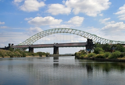 |
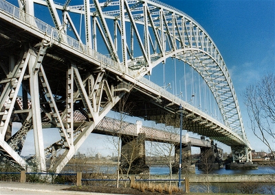
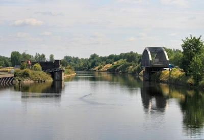
The Railway and Road Bridges, Runcorn The Silver Jubilee Road Bridge (often known simply as the Runcorn Bridge) crosses the River Mersey and the Manchester Ship Canal at Runcorn Gap. It was opened in 1961 as a replacement for the Widnes-Runcorn Transporter Bridge and has a span of 1,082 ft (330 m). It was widened in 1975-77, after which it was given its present name in honour of the Queen's Silver Jubilee. The cost of constructing the bridge was £2,433,000 and at the time of its construction it had the third longest steel arch span in the world. The bridge transformed Runcorn from an effective cul-de-sac into a town with through traffic. Trade at the Port of Runcorn increased sixfold between 1960 and 1970 and its presence enabled the development of Runcorn New Town in the late 1960s and 1970s. Traffic on the bridge has continued to grow to over 80,000 vehicles a day and there is frequent congestion. In order to alleviate this, the building of a six-lane toll bridge to the east, to be known as the Mersey Gateway, is planned. |
|
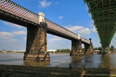 |
The Railway Bridge, Runcorn The railway bridge, built for the London and North Western Railway, was opened in 1868 and carried a footway, especially useful as the construction of the Manchester Ship Canal here on the Runcorn side had made the existing ferry crossing complicated. It is also known as the Ethelfleda Bridge or the Britannia Bridge. The footway was closed in 1965. The bridge today carries rail traffic on the Liverpool branch of the West Coast Main Line. It consists of three wrought iron spans of 305 feet (93 m), each on two sandstone abutments with foundations at a depth of about 45 feet (14 m) below water level. From the north side of the river, the bridge is approached by a viaduct of 49 arches, a short embankment, and 16 more arches. From the south it is approached by a viaduct of 33 arches. At its completion, the bridge was the longest of its time. The bridge is sometimes named after Ethelfleda because the southern abutments and pier were built on the site of the Saxon fortified town erected by her in 915 (parts of the bridge are castellated to reflect this). There are three shields above the footway showing the Coat of Arms of the City of London, Britannia (from the crest of the railway company - hence the other name of the bridge) and the Liver Bird of Liverpool. |
|
 |
St. Mary's Church from the Ship Canal, Runcorn | |
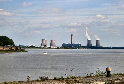 |
Fiddler's Ferry Power Station from the Ship Canal, Runcorn | |
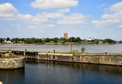 |
The Old Quay Lock, Runcorn This lock on the east side of Runcorn Gap was originally the terminus of the Runcorn to Latchford Canal, an area known as Old Quay, where a dock was opened in 1826. |
|
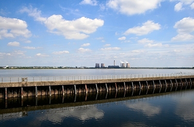 |
The Manchester Ship Canal and the Mersey at Runcorn | |
 |
The Old Quay Swing Bridge, Runcorn The Old Quay Swing Bridge crosses the Manchester Ship Canal and connects Runcorn to Wigg Island Nature Reserve. The Island is named after Charles Wigg, who established the first industrial factories on the site in the 1860s for extracting copper from its ore. The works expanded and diversified, supported by the later construction of the Manchester Ship Canal alongside the site. During the Second World War, Wigg Works East, then called Randles Works, was used for the production of mustard gas. ICI then ran the site until manufacturing ended in the 1960s. The land was reclaimed to provide woodland and pathways and the nature reserve was officially opened in 2002. Today the area supports a rich variety of native wildflowers and provides fine views over the River Mersey. |
|
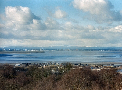 |
The Mersey Estuary and the Clwydian Hills from Runcorn Hill At Runcorn Hill, wide vistas over the Mersey Estuary are combined with the vertiginous cliffs of the old Runcorn Hill Quarry. Runcorn is a closed book to most non-Runcorners, seemingly cut off as it is by the encircling expressways. It was so to me until recently when I went exploring. I was expecting a good view of the river but was hardly prepared for the drama of the location. |
 |
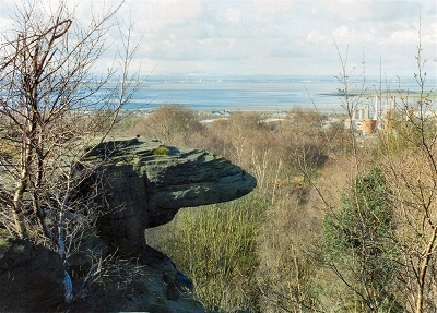 |
The Frog's Mouth, Runcorn Hill | |
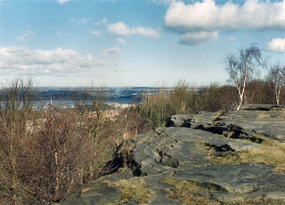 |
The Cliff Tops, Runcorn Hill | |
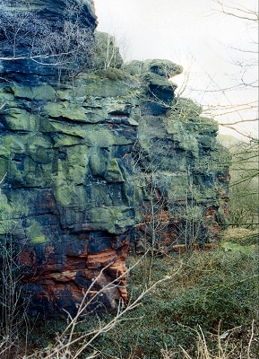 |
Sandstone Cliffs, Runcorn Quarry There has been quarrying at Runcorn since Norman times when Halton Castle and Norton Priory were built, and possibly since Roman times (for Chester) and it was a major industry by the 18th century. Quarrying ceased at Runcorn Hill around 1850, but new quarries were opened and this site was used for spoil from those workings. Some of the present paths cut through the rock were the routes of tramways constructed to transport the rubble. Impressive though the present cliffs are, the quarry was apparently three times as deep before it began to be filled in. |
|
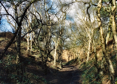 |
Woodland, Runcorn Hill Runcorn Quarry and the woodland area behind make up Runcorn Hill Local Nature Reserve. It is a small area, laid out with a network of paths, but is of exceptional interest. |
|
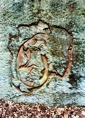 |
Lizard Carving, Runcorn Hill Quarry | |
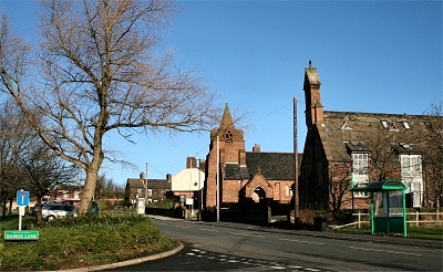 |
Weston Village The old village is located high up on the side of Runcorn Hill with fine views to the west and south despite the encroachment of industry. The village itself has kept remarkably unspoiled by modern developments. The church is the Parish Church of St. John the Evangelist, built in 1896-7. |
|
| Weston in Lewis's Topographical Dictionary of England (1848) It is situated at the junction of the rivers Weaver and Mersey, and comprises 880 acres, whereof about one-half is arable and one-half pasture, of fertile soil, and picturesque aspect. Splendid views are obtained of a portion of North Wales, and of Liverpool, Chester, and the surrounding country. There are three excellent red-freestone quarries, called respectively the North, East, and South, capable of employing 600 or 700 men, and of raising annually one million cubic feet of stone; they are the property of John Tomkinson, Esq., of Liverpool and Runcorn, and the stone is sent to all parts of the kingdom by the Weaver canal, which adjoins the estate. The traffic consists chiefly in salt, salt-rock, and coal. |
||
| Weston in The Beauties of England and Wales, Vol II, Edward Wedlake Brayley and John Britton (1809) Weston is a retired, but beautiful little village, nearly opposite the junction of the Weaver and the Mersey. Its vicinity is enriched by some of the most luxuriant natural scenery in Cheshire, though its secluded situation, at a distance from the course of the roads, has hitherto been the means of concealing its beauties from the public view. The brow overhanging the point of land where the rivers meet commands a magnificent water prospect, which at full tide exhihits the broadest part of the estuary of the Mersey, stretching many miles before the eye till it is completely land-locked by a turn in the channel, and has the appearance of an extensive lake, bordered on the Cheshire and Lancashire side by a variety of ground, partly open, and partly covered with fine woods. |
||
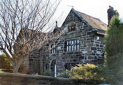 |
The Old Hall, Weston Weston retains a number of very old buildings. The sandstone Old Hall is dated 1607. |
|
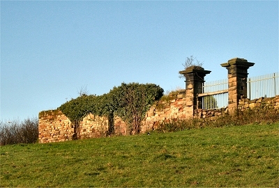 |
Rock Savage, Clifton Only the ruins remain now of Rocksavage, a vast house built of local red sandstone in 1568 by Sir John Savage. It was very similar in appearance to Brereton Hall, which was built about the same time and which still exists near Congleton (a family connection). It was the second largest house in Cheshire; only Cholmondley Hall near Bickerton was larger. The house stood in formal Elizabethan gardens and it was sited so as to command views across the Weaver valley towards Frodsham and the Welsh hills beyond. It was looted and damaged during the English Civil War but restored. An account of the house in 1778 gives a clear picture of a stately home 'with delectable gardens, orchards and walks'. The estate passed to the Cholmondeley family, who eventually had no use for Rocksavage and it was allowed to decay into a ruin. The stone was robbed to build farm buildings and walls. A tall pinnacle of masonry existed until the 1960s when it collapsed in a gale. Today only a portion of the garden wall and the gate posts remain. It is hard to imagine such a grand establishment in this area now hemmed in by industry, although Clifton itself is a microcosm of rurality against all the odds. |
|
| Rock Savage in The Beauties of England and Wales, Vol II, Edward Wedlake Brayley and John Britton (1809) Rock Savage is a magnificent pile of ruins, embosomed in wood, and seated on a rising ground above the river Weaver. This mansion was the residence of Sir John Savage, by whom it was built in the reign of Queen Elizabeth, but, by the marriage of Elizabeth, daughter and heiress of Richard Savage, Earl Rivers, with James, Earl of Barrymore, it was conveyed, together with the estate, into that family. It is now the property of Earl Cholmondeley, who inherited it from his grand uncle, General Cholmondeley, who obtained it by marrying Lady Penelope Barry, daughter of the above Earl James. After this marriage the place was neglected, and fell into such speedy decay that a gentleman, who was born in the house, is recorded to have followed a pack of hounds through it in pursuit of game. Some portion of its stately front, consisting of a fine gateway, with lofty turrets on each side, is still standing, as well as part of one of its sides. The rest of the pile consists only of foundation walls, broken vaults, and heaps of rubbish, overgrown with weeds, the whole surrounded with enclosures of dilapidated walls. |
||
| Clifton in Lewis's Topographical Dictionary of England (1848) This place has been called Rock-Savage, since the erection of a splendid house by Sir John Savage, in 1565. The township comprises 577 acres, whereof the prevailing soil is clay; and consists of only the manorial mansion and its demesne land, now in the possession of the Marquess of Cholmondeley, who enjoys the title of Earl of Rock-Savage. |
||