|
|
|||||||||
|
|
|||||||||
Home Page: merseySights  |
Home Page: allertonOak  |
|||
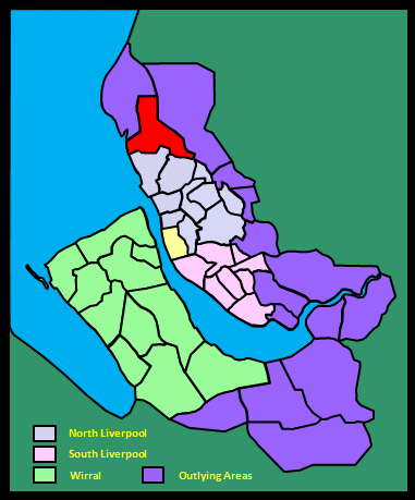 |
| CLICK A BOOTPRINT FOR A RELEVANT WALK - LINKS TO OTHER SITES AT THE BOTTOM OF THE PAGE |
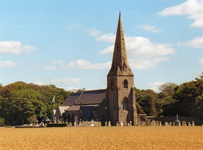 |
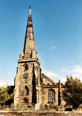
St. Mary's Church, Little Crosby Little Crosby is a historic unspoilt village just to the north of Liverpool. It adjoins the Blundell family estate at Crosby Hall. The family goes back to the Norman conquest and has lived here since the 15th century. It is thought that the church stands on the site of a Viking chapel called the Harkirk. In 1611, William Blundell established a burial ground here for Roman Catholic recusants denied burial at Sefton Church in the aftermath of the Reformation. A substantial hoard of Viking coins was found at this time. The present church was completed in 1847. |
 |
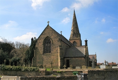 |
St. Mary's Church, Little Crosby | |
| Little Crosby in Lewis's Topographical Dictionary of England (1848) William Blundell, Esq., is now lord of the manor, and owner of the township, which comprises 1740 acres, and of which the surface is level, with a light sandy soil. His seat, Crosby Hall, was built by his ancestors in 1500, and has since been altered and improved at various times, a portion bearing the date 1647; the park is gracefully laid out, and well wooded, and among the trees the laurel is unique. [...] The Roman Catholic chapel here, dedicated to the Blessed Virgin, was rebuilt in 1847, at the sole cost of Mr. Blundell, amounting to £2500; it is a handsome structure of stone, in the early English style, with a tower surmounted by a spire. The interior is richly ornamented [...]. At Harkirk, an ancient burial-ground, a number of Saxon and other ancient coins, of which a print is preserved in the British Museum, were found in April, 1611; and in 1847 were discovered the remains of an arched window. |
||
| Little Crosby in the Victoria History of the County of Lancaster (1907) This township lies to the north of Great Crosby, Thornback Pool being the boundary on that side. Extending along the coast, a wide belt of sand-hills, in which are rabbit warrens, forms an efficient protection to the low-lying land from the inroads of the sea. Some of the inhabitants are fishermen, who reap a harvest of shrimps, flukes, and cockles from the sea and broad firm sands. Excepting those which cluster about Crosby Hall, there are but few trees or hedges, fields being principally divided by ditches. The alluvial soil produces good crops of potatoes and corn, whilst there are also meadows and pastures. [...] The village, hall and park are at the southern end of the township; to the north are Moorhouse and Hightown, a modern hamlet; on the shore near the last-named is a lighthouse, built in 1839. [..] There are six crosses, one being in the village. At Harkirk, now within the park, a number of Anglo-Saxon coins were found in 1611. |
||
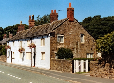 |
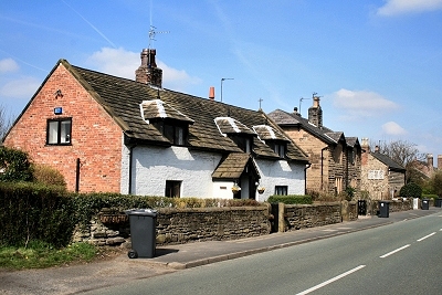
Cottages, Little Crosby The village has a number of attractive early 17th century cottages, many constructed of sandstone from a local quarry on Delph Road (now filled in). |
|
 |
Cottages, Little Crosby | |
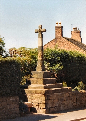 |
Village Cross, Little Crosby The name Crosby comes from the Old Norse for village with a cross. |
|
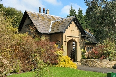 |
Crosby Hall Lodge, Little Crosby | |
 |
Little Crosby from Dibb Lane | |
 |
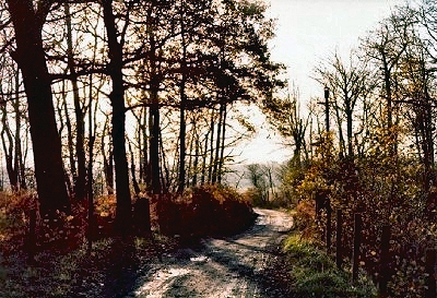
Sniggery Wood, Little Crosby | |
 |
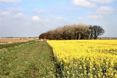
Ince Woods Ince Blundell is flat, agricultural fen country with very few trees. Ince Woods are a substantial remnant of the ancient woodland, protected against development, particularly in regard to the once posited new road from the north of Liverpool to Formby. It appended the name of the local Blundell family near the end of the 14th century to distinguish it from Ince near Wigan. The first Blundell to have had an interest in the land appears to have been Richard in the late 12th century. |
|
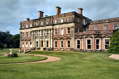 |
Ince Blundell Hall The present hall is a magnificent Georgian mansion that can not, unfortunately, be visited by the general public as it is now a private nursing home. According to the Pevsner Guide, it is 'one of the finest expressions of the Neoclassical ideal in the country'. The Blundell family settled here before the 14th century, when the site was a low island in the mosses. Building started ca. 1720 and was completed in the last quarter of that century. It is situated in a large walled park with three imposing gateways. This photograph is ©Mr Brendan Oxlade, sourced from the National Monuments Record and used by permission of English Heritage. |
|
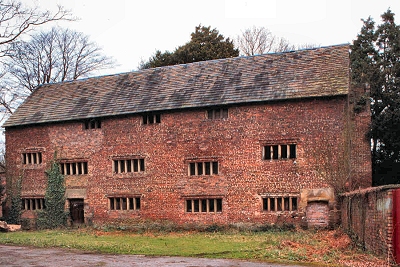 |
Ince Blundell Old Hall This odd building of ca. 1590-1620 is located in the grounds of the present hall. It isn't in fact the Old Hall (which stood on the site of the new one), but its original function is a mystery. It was used for drying hops in the 19th century, and restoration had been considered, but no further progress made. It can not be visited by the general public. This photograph is sourced from the Heritage at Risk Register and used by permission of English Heritage (ref. M983233). |
|
| Ince Blundell in the Victoria History of the County of Lancaster (1907) Ince Blundell embraces a considerable area of flat, fen country laid out in pastures and cultivated fields, where corn, root crops, and clover-hay are produced in a rich alluvial soil. The River Alt forms a tortuous boundary along its north-eastern, northern, and western edges. The low-lying fields are mostly separated by deep ditches, which serve for division and drainage. Near the sea coast, and near the mouth of the Alt, there is a narrow band of sandhills. The trees clustering about Ince Blundell Hall and village emphasize the scarcity of timber in the district, for they stand out as an abrupt mass in the bare landscape. Solitary trees here and there incline to the south-east, showing the direction of the prevailing winds. [...] The brook called Twine Pool and Hynts Brook divides Ince from Thornton. [...] The village is situated near the middle of the township. There are hamlets called Carr Houses and Lady Green; North End includes Alt Grange. The greens have been enclosed. There are crosses upon ancient bases in the village. The 'flowering' of the cross used to take place on Midsummer Day. |
||
 |
St. Helen's Church, Sefton Sefton is the tiniest of hamlets, though it gives its name to the entire borough. It was the seat of the Norman Molyneux family, who lived in a large moated house called Sefton Hall that once stood just over the road from the church. They moved to Croxteth Hall in 1710 and later became Earls of Sefton. St. Helen's, or Sefton Church as it is often called, is based upon a Norman church, the private chapel of the Molyneux family, dating from 1170. The original church, not much of which remains, was added to over the centuries, with the spire appearing around 1320. It was substantially in its present form by 1550; gravestones date back to the 17th century. Thomas Pennant, describing a visit to Sefton in 1773, wrote, '... placed on a vast range of fine meadows, that reach almost to the sea and in a great measure supply Liverpool with hay. It is watered by the Alt, a small trout stream; but after the first winter flood is covered with water the whole season, by reason of want of fall to carry it away.' |
|
| Sefton in Lewis's Topographical Dictionary of England (1848) The western townships are bordered by the Irish Sea and the mouth of the Mersey, a range of dreary sandhills forming a barrier along the shore, which is lined with marshes and covered with rabbit-warrens. The river Alt, fed by numerous rills, flows by Aintree, Lunt, and Ince-Blundell, and discharges itself into the sea to the north, below Formby Point. At Sefton, this stream resembles a canal, and in wet seasons overflows the meadows, a flat district extending several miles, which, during inundations, assumes the appearance of an arm of the sea. The Leeds and Liverpool canal intersects the parish. The principal halls are those of Little Crosby and Ince-Blundell. Sefton Hall existed in 1372, and was a stately pile, with a circular moat (still in existence) inclosing about a quarter of an acre of elevated ground, opposite the church. The farmhouse which subsequently occupied the site of this ancient seat of the Molyneuxs, has been taken down, and all that now remains of the mansion is a few heaps of stones scattered from its strong and massive walls. A brewery here, established about a century ago, is conducted by Mr. Molyneux Rothwell. [...] The church is a large and handsome structure, and one of the finest in the county, originally erected in 1111, and partly rebuilt in the reign of Henry VIII by Anthony Molyneux, a distinguished preacher, then rector. It is partly Norman, and partly in the later English style, with a lofty spire; and the interior is remarkably elegant. The chancel, separated from the nave by a magnificent screen, contains sixteen richly-sculptured stalls, and numerous monuments to the family of Molyneux, of whom Sir William performed signal acts of valour under the banner of the Black Prince, at Navaret; as did Sir Richard in the battle of Agincourt, and another Sir William in that of Flodden-Field. In what is called Lord Molyneux's chapel are several modern monuments of the family, one of them, particularly fine, in white marble, to the memory of Caryll, Viscount Molyneux, who died in 1699. A sunk forest on the coast, is one of the most remarkable characteristics of the parish; and so abundant is the timber imbedded in the earth, generally two feet or more below the surface, that fifty loads of trees, chiefly of oak, are sometimes found in a single acre. |
||
| Sefton in the Victoria History of the County of Lancaster (1907) The eastern boundary is formed by the River Alt, except where the present course of the stream has been restricted to the centre of Sefton meadows, the whole of these lying within the township. In time of frost they are flooded for the amusement of skaters. The church and the mill stand at the western edge. A few dwellings amid a clump of trees cluster round the church; there are also hamlets called Sefton Town, Buckley Hill, and Windle's Green. The moated site of the ancient house of the Molyneux family lies to the south-east of the church, but nothing remains above the ground of the buildings finally dismantled in 1720. Part of it was standing till 1817. Close to the site, on the south, is a farmhouse, known as The Grange, retaining some seventeenth-century details, and a barn of late sixteenth-century date, though much patched with later work. The mill over the Alt is said to have been built in 1595, and has a four-centred doorway and chimney-piece which may well be of that date. Wheat, barley, oats, and rye are grown, as well as potatoes; but cabbages are now the chief crop. |
||
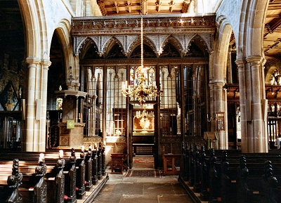 |
St. Helen's Church, Sefton The interior of the church contains much early woodwork including the three screens visible here, dating from the early 16th century, an octagonal pulpit from 1635, a muniments chest ca. 1350 and many carvings. There are brass monuments to Tudor members of the Molyneux family, but the oldest is that to Sir William Molyneux (d.1290). There is also a 1596 bible. A notable rector in Tudor times was the aptly named Parson Nutter, called The Golden Ass by Elizabeth I because of his wealth and ignorance, who wasn't known for his application to the job but nevertheless left a huge hoard of gold under his deathbed. |
|
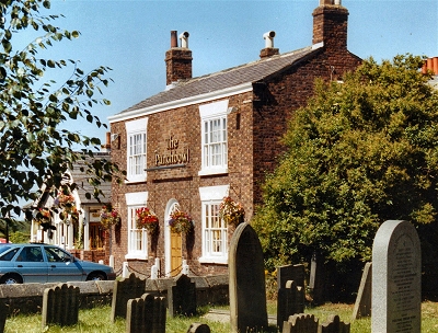 |
The Punch Bowl, Sefton The Punch Bowl on Lunt Road is almost as much a feature of the hamlet of Sefton as the ancient church next door. Modernised and extended, it is a nice place to visit in a timeless rural setting. |
|
| Lunt in the Victoria History of the County of Lancaster (1907) Lunt is situated in the flattest fen district drained by the River Alt, which also forms its north-eastern boundary. The marshy pastures are liable to floods during winter and in wet seasons. In the southern portion there are cultivated fields where cereals and root-crops thrive in a soil consisting of a mixture of sand and clay. Hedges are scanty and trees few and far between. It was formerly a hamlet of Sefton, but its separation seems to have been accomplished before 1624. [...] St. Helen's well [still on the map], close to Sefton church, is a wishing well; a pin had to be thrown in, and if it could be seen at the bottom of the well the omen was favourable. |
||
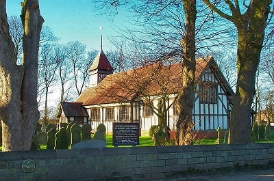 |
St. Michael and All Angels, Great Altcar Altcar appeared in the Domesday Book, where it was recorded as wasteland of no value). The name describes the area around the tiny Hamlet of Great Altcar. This is very flat, bare and low-lying country, Great Altcar being only 12ft (4m) above sea level. The marshes, now prime agricultural land, were once the flood plain of the River Alt, but were drained by a network of ditches and flood gates were constructed near the mouth of the river by the end of the 18th century. In former times the villagers of Altcar used to challenge those of Formby, then chiefly a fishing village, to fight at Fleam Bridge, which crossed the Downholland Brook behind Tesco's superstore (which wasn't there then, by the way). I believe this tradition is still upheld at Christmas when the turkeys go on sale. A little fair was also once held, where a mock mayor was elected, the incumbent being the first to get incapably drunk. He and fantastically-dressed neighbours then went in procession around the houses for money or drink. It seems a bit more subdued these days. |
|
| Altcar in Lewis's Topographical Dictionary of England (1848) The Alt bounds the parish on the south, having various channels by which the marshes here are drained, and the lower lands thus present the appearance of a Dutch farm with drains and embankments. The grounds are subject to floods, which are carried off by a steam-engine, erected in 1842, the water being thrown into the Alt, which merges into the Irish Sea at Formby Point. A large quantity of hay is produced in the parish; and there is a good stone-quarry, the material of which is used for building purposes. [...] The principal village, called Great Altcar, is a straggling place, consisting chiefly of farmhouses, extending on a slight eminence towards the church, which stands in the western extremity of the parish. Little Altcar is a hamlet adjacent to Formby; and Altcar Hall is an ordinary farmhouse, over the door of which were formerly the arms of the noble family of Molyneux. [...] On the coast, near the mouth of the Alt, oak, ash, and fir trees are dug up, after ages of immersion in a subterranean forest at that place. |
||
| Altcar in the Victoria History of the County of Lancaster (1907) The situation and aspect of this parish and township are sufficiently indicated by its name - the carr or marshland beside the Alt. It lies on the right bank of this stream, as it flows north-westward, westward, and then southward to the Mersey estuary. The boundary on the east is practically coincident with the 25ft. level, till it reaches Lydiate Brook at the Frith Bridge. The old course of the Downholland Brook, crossed by the old Fleam Bridge, was the western boundary, but has been greatly altered, and now is led straight to Alt Bridge. The narrow strip of land belonging to Altcar, which borders the Alt down to its mouth, is over two miles in length. On the widest portion, between the southern course of the river and sea shore to the west, is the Altcar rifle range. There is here a twelve-gun battery for the defence of the Mersey. [...] The whole is flat and lies very low. [...] The village of Altcar, or Great Altcar, with a long crooked street, is in the north-west, on ground which is only about 12ft. above sea level. Hill House, to the east of the village, is 40ft. above sea level. To the south of this house is Carr Wood. Altcar Hall, a farmhouse, adjoins the church at the west end of the village. The township is very sparsely timbered; small trees are grouped about the scattered farms, and there are a few limited plantations to the east. As in other low-lying townships the fields are mostly divided by ditches, regularly-planted hawthorn hedges being seen along the high roads and about the villages. Corn, potatoes, and other root crops are extensively cultivated, besides quantities of hay. [...] The Southport and Cheshire Lines Committee's railway, opened in 1884, runs through the parish near the eastern boundary, with two stations, called Lydiate, and Altcar and Hill House. [...] There was a sandstone quarry near Hill House; this is now filled with water. The history of this isolated place has been uneventful. One stormy incident, however, is recorded. It arose out of the revival of religious persecution caused by the Oates plot. In February, 1681?2, eight officers of the law visited Altcar to distrain the goods of John Sutton and Margery Tickle, recusants. They seized cattle accordingly, and waited from nine to three o'clock expecting that the cattle would be redeemed. Receiving an intimation of a projected rescue the sheriff's men tried to get away with their capture, but were opposed by a party of about twenty men and women, armed with long staffs, pitchforks, and muskets, who easily routed the officers, beating them, leaving them in the mire, and driving the cattle away. Six men were badly injured, two so severely that life was despaired of. There is nothing stated as to the result, beyond a hint that the king was about to intervene to prevent further proceedings. The modern celebrity of Altcar is due to the Waterloo coursing meeting which takes place here about February. [...] In former times the villagers of Altcar used occasionally to challenge those of Formby, then chiefly a fishing village, to fight, the combats taking place at Fleam Bridge, on the boundary. Mid Lent Sunday was known as Braggot Sunday, from a specially-made non-intoxicating drink called Braggot; its place was afterwards taken by mulled ale. A labourer expected four eggs from his employer, which he took to the ale-house, where the eggs, with spices, were drunk in hot ale. A little fair was held; a mock mayor was elected - the first man who succumbed to the effects of the drinking that took place - and he and fantastically-dressed neighbours went in procession, calling at various houses for money or drink. |
||
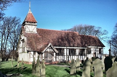 |
St. Michael and All Angels, Great Altcar The present church of St. Michael and All Angels dates from 1879, though it is built in a timber and plaster style more typical of Tudor times. Such a church did, in fact, exist in the 17th century, and probably accounts for the stylistic affectation. Altcar Hall, now a farm house still standing next door to the church, was the parsonage, though later it became an inn. The Tudor church was destroyed by fire and a new, evidently rather small and plain brick building, was consecrated soon after in 1747. Before the drainage of the marshes, it is recorded that boats were sometimes required to get to church and stepping stones were needed between cottages. One farmer kept a boat go and milk the cows. |
|