|
|
|||||||||
|
|
|||||||||
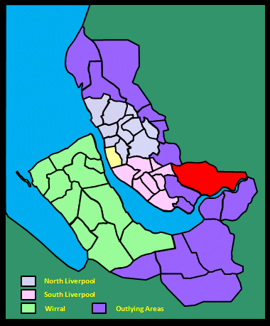
Home Page: merseySights  |
Home Page: allertonOak  |
|||
 |
| CLICK A BOOTPRINT FOR A RELEVANT WALK - LINKS TO OTHER SITES AT THE BOTTOM OF THE PAGE |
| Tarbock in Lewis's Topographical Dictionary of England (1848) The township [...] is flat, and the soil a strong clay, with some parts sandy. There is a redsandstone quarry; coal is abundant, and many of the inhabitants are employed in the collieries. A brewery, established about eighty years ago, is conducted by Mr. George Fleetwood. |
||
| Tarbock in the Victoria History of the County of Lancaster (1907) The south-western boundary of Tarbock is formed principally by the old course of the Ditton Brook and its affluent the Netherley Brook. The northern boundary is in a great measure formed by two little brooks which divide it from Whiston, running one east and the other west, and uniting about the centre to form the Ochre Brook, which flows south and south-west through the township. Tarbock Green is near the centre of the township; Coney Green is a hamlet in the northern corner. [...] The flat country is divided into pastures and cultivated fields, where crops of potatoes, turnips, oats and wheat thrive in a loamy soil. It is not at all picturesque owing to its level nature and the absence of woods, excepting those of Halsnead Park, which fringe the township on the north. A little relief is given to the otherwise uninteresting landscape by the Ditton Brook, which is rather a pretty stream. [...] The principal industry is agriculture. There is also a brewery. In 1824 there were several collieries at the northern end of the township, but they have now been worked out. [...] A little hoard of silver and copper coins was discovered at a farm called the Old Sprink in 1838. |
||
| Ditton in the Victoria History of the County of Lancaster (1907) On the south, Ditton Brook and the low-lying marshy ground along it must once have formed a definite physical boundary for the township. In the east-central portion is Ditton village, with Ditchfield [no longer extant] to the west and Hough Green to the north. The eastern and northern boundaries are formed in great measure by two small brooks, Moss Brook dividing Ditton from Widnes, and what was formerly called Halliwell Brook from Cronton. The country is flat and divided into pastures and arable fields where wheat and oats are generally grown on a clay soil. There are but few trees and scanty hedges, for the locality is too close to the manufacturing town of Widnes to escape the inevitable effects of smoke and chemical fumes. |
||
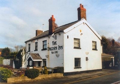 |
The Unicorn Inn, Cronton The old village of Cronton near Widnes was first recorded in Norman times as Crohinton. The Unicorn Inn on Cronton Road (A5080) dates from 1752. The village is documented as far back as Norman times and was once known for watchmaking. Conveniently situated near the pub are the old village stocks, along with the remains of St. Anne's Well, whose waters were once said to be good for rheumatism (curing it, presumably), but which was filled-in in the late 19th century. |
 |
| Cronton in Lewis's Topographical Dictionary of England (1848) The surface is principally flat; but on the east side is Pex Hill, the residence of Thomas Brancker, Esq., from which a most extensive view is obtained, embracing the Cheshire hills and the Welsh mountains. There is an excellent redstone quarry. |
||
| Cronton in the Victoria History of the County of Lancaster (1907) Cronton [...] is situated on ground undulating in the north, and gradually sloping to quite a flat surface in the south. The village is situated about the centre of the township, and is a favourite resort for cyclists and picnic parties, both from Liverpool and Widnes, on account of a public recreation ground on Pexhill. This hill, rising to only 200 ft. above sea level, is covered with heather and gorse, and on the top are the Widnes Corporation reservoirs, formed in 1868. There are but few plantations, but the most part of the country is occupied by arable fields, where good crops of turnips, wheat, oats, and barley are grown in a loamy soil. There are decidedly fine views of the surrounding country to be had from Pexhill. [...] Watchmakers' tools are made here. The remains of a cross - pedestal and part of the shaft - may be seen near the hall; the stocks remain, being in the village. Formerly there was a well close by dedicated to St. Anne, but known as the Stocks Well; it is now filled up. |
||
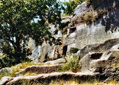 |
Pex Hill Quarry, near Cronton The old quarry is an interesting and atmospheric place. Sandstone had been quarried here since the 16th century, though it has been disused for over 100 years. |
|
 |
St. Mary's Church, Widnes The first church in West Bank, Widnes, known as Widnes Dock Church and dedicated to St Mary, was opened in 1858. This church consisted only of the nave and was never completed as it had been built on chemical waste, which subsided, leading to bulging of the walls and twisting of the roof. The present church of St. Mary, Widnes Parish Church, built of red-flecked sandstone, dates from 1908-10. |
|
 |
Widnes Dock and Quay 1000 years ago, Widnes was an area of poor soil 'half marsh and half moor'. Sometime around 1180, the church was constructed at Farnworth, inland from the river. The ferry across the Mersey at Runcorn Gap (where the bridges are now located) was in existence at that time and was an important route then as it is today. There was a pub was here serving local eel pie. A village known as Woodend had been establised by the river by the 18th century and was a tourist destination for Liverpudlians. By 1845, the area around Widnes Dock was the world's first interchange complex between a canal (the St. Helens Canal), a railway and a dock. Among other things, Cheshire salt was off-loaded for the glass-makers of St Helens here in return for Lancashire coal for Northwich. The Victorian town grew rapidly on the back of the burgeoning chemical industry. |
|
| Widnes in the Victoria History of the County of Lancaster (1907) Widnes appears at first to have been the name of the district, the township name being Appleton. This hamlet lies close to the centre, with Farnworth, the site of the chapel, on the extreme north, Upton to the north-west, and Denton to the east. Simm's Cross and Lugdale have recently become hamlets or suburbs of Widnes town. The marshy district by the Mersey was interrupted by a projecting piece of higher land, whence a crossing could be had to Runcorn on the Cheshire side. On this ground the town of Widnes has sprung up. The flat and open country close to the town itself is absolutely devoid of anything beautiful; a district more lacking in attractive natural features it would be difficult to conceive. A great cloud of smoke hangs continually over the town, and choking fumes assail the nose, from various works. In the face of such an atmosphere it is not to be wondered at that trees and other green things refuse to grow. Even the riverside is unpicturesque and rendered unpleasant by the unsavoury mud which the tide leaves stranded upon rocks and stones. The more remote and countrified parts of the township consist of open fields, with the minimum share of trees. Crops, such as oats, potatoes, and turnips, thrive in a clayey soil. The London and North Western Company's railway from Liverpool to Manchester passes through the town, where there is a station. To the west there is a junction with the same company's main line from London to Liverpool, which here crosses the Mersey by a great bridge built in 1868, at one side of which is accommodation for foot passengers. The St. Helens line branches off from Widnes station; there is another station at Appleton, and a third at the northern boundary, called Farnworth and Bold. The Cheshire Lines Committee's Liverpool and Manchester section crosses near the centre and has a station called Farnworth, to the south of this village; there is also a branch line to Widnes town, with stations there and near the eastern boundary, called Widnes (Central) and Tanhouse Lane. The St. Helens Canal has its terminus in the docks at the eastern side of the town. Runcorn Gap was the old name of the part of the Mersey between Widnes and Runcorn. Sixty years ago there were but a few scattered dwellings by the side of the Mersey, but the establishment of chemical works there about 1850 speedily brought an increase of population, and the busy industrial town - the centre of the alkali trade - has grown up among and around the works. There are also soap, oil, and paint factories, iron foundries, and copper-smelting works. There are toolmaking and some minor industries at Farnworth. |
||
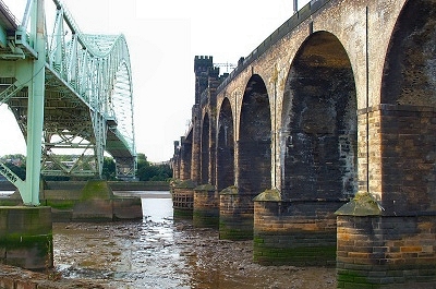 |
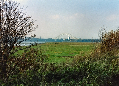
The Runcorn Bridges There has been a ferry here at Runcorn Gap on the River Mersey since the 12th century. The railway bridge (on the right) was opened in 1868 and carried a footway, especially useful as the construction of the Manchester Ship Canal on the Runcorn side had made the ferry crossing complicated. |
|
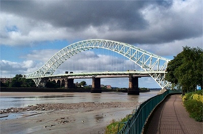 |
The Runcorn Bridges Despite the countless hours of my life wasted in traffic jams during 18 years of crossing the Runcorn Road Bridge (in the foreground) to get to and from work, I still regard it as a graceful and alluring structure. I remember seeing it partially constructed, with the two arms groping towards one another over the void. I also dimly remember crossing on the old transporter bridge just upstream. Completed in 1905, this was closed in 1961, the day before the present bridge was opened. Millions of migrating birds swarm around the bridge at certain times of the year, taking turns for the limited landing space and distracting hapless drivers with a stunning aerial display and a deluge of guano. |
|
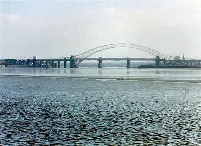 |
The Runcorn Bridges from Pickering's Pasture The view of the bridges from the downstream side at Pickering's Pasture. Pickering's Pasture is a local nature reserve and a peaceful haven for wildlife and wild flowers with fine views over the River Mersey. |
|
 |
The St. Helens Canal at Spike Island, Widnes The St. Helens Canal (known as the Sankey Canal before 1845) was completed in 1757, making it the first industrial canal in Britain. It was first used mainly to transport coal for the chemical industry, with some iron ore and corn. |
|
 |
The St. Helens Canal at Spike Island, Widnes Though peaceful and rural now and an important haven for wildlife, Spike Island was the birthplace of the British chemical industry in the 18th century. For much of the 20th century, it was a derelict wasteland until reclamation began in 1975. The St. Helens Canal meets the River Mersey here at Widnes Dock. |
|
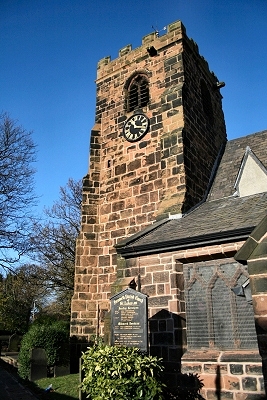 |
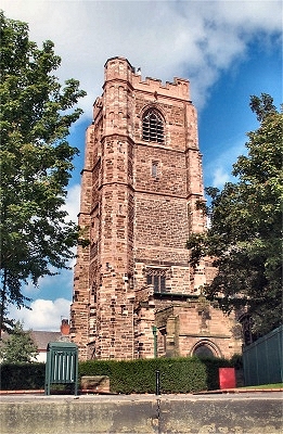
St. Lukes Church, Farnworth Not many Merseysiders west of Hough Green have even heard of the ancient township of Farnworth, now part of the northern conurbation of Widnes, though historically it was more important than the latter, the chapelry incuding Bold, Cronton, Ditton, Widnes, Cuerdley, Penketh, and Great Sankey. The first church was founded here in around 1180. Originally dedicated to St Wilfrid, it only assumed its present name in 1859. The first extension was about 1280-1300, when the north aisle was added. Between 1360 and 1380 the south aisle was added and around this time the tower was also built. The Chapel was added in 1406 and in 1431 the east end was extended. In 1500 the Cuerdley chapel was added to the south of the church. |
|
| Farnworth in Lewis's Topographical Dictionary of England (1848) The chapelry [...] being rather elevated land, commands views of the Cheshire hills and the Welsh mountains: the soil is of various quality; and red sandstone is quarried. The manufacture of watch-movements is carried on to a considerable extent, as is also that of sailcloth. Cattle-fairs are held in spring and autumn. |
||
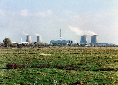 |
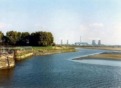
Fiddler's Ferry Power Station and Widnes Warth | |
 |
Widnes Warth Marshes A distant view of the Runcorn bridges over the marshes from the St. Helens Canal. Widnes Warth is a haven for birds, with areas of salt marsh and mud flats, that has recently received Local Nature Reserve status. |
|
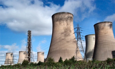 |
Fiddler's Ferry Power Station There are several major landmarks in the Merseyside area, but none as dominating as the power station at Fiddler's Ferry. The plant is truly immense, extending for over half a mile (1 km), and in certain atmospheric conditions seems to generate its own climate over a wide area. OK, so this is not going to appeal to everyone's aesthetic sensibilities, but the cooling towers and their disposition have a certain eye-catching grace, and the size of the structure and the drama of the atmospheric perturbations can be awe-inspiring. It is a fitting monument to an area that was once a cradle of the industrial revolution. |
|
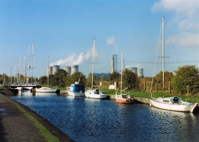 |
Fiddler's Ferry Yacht Haven Near this spot was the location of the Concrete Seacraft Company, which built ships out of concrete during World War I because of shipping losses and the shortage of steel plate. Two 1000 tonners, the Cretecamp and the Cretecove were both launched successfully and worked until the 1920s. They were among a large number of dumb barges and tugs built of concrete by the Admiralty (one or two are afloat still) and some were towed across the Atlantic. At the end of the war, steel once again became cheap and plentiful, and the company moved into the construction of pre-fabricated houses. My thanks to David Long for this information. |
|
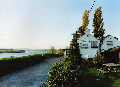 |
The Ferry Tavern, Fiddler's Ferry It is not known how long there has been a pub here near Penketh serving travellers waiting for the tide to cross the river Mersey by ferry to Moore or to voyage along it. The place name was first recorded as Penket in 1242 from the Welsh for 'wood's edge' (Pencoed). The ferry was here over 800 years ago, at which time there was a bridge at Warrington and another ferry at Runcorn (neither of which towns boasted more than a few hundred inhabitants in those days), this being the narrowest part of the river between. The present pub building dates from 1762. The name of the ferry probably comes from that of the land owner long ago called Adam Le Vieleur, Lord of the Manor of Penketh, a vielle being a mediaeval fiddle. A traveller in the 1800s wrote 'Here is also a muddy but fairly large rowboat which plies from the stone jetty outside the inn to some point on the Cheshire side. This is not identified by either farm or road access. The inn seems to be quite comfortable for visitors of a mildly adventurous mind. At night the sound of the tide must echo through the room, and in the wind there will be resounding notes'. The ferry service came to an end around 1890 when the Manchester Ship Canal cut off access from the south bank. The present pub, though modernised, has plenty of character (not scary at all!) and a superb situation on the marshes right next to the river. |
|
| Penketh in the Victoria History of the County of Lancaster (1907) This township [...] has the typical features of the districts situated along the Mersey, being decidedly flat, sparingly timbered, with open fields. The soil is loamy, with clay lying below the surface, the crops raised being principally barley, oats and wheat, with occasional fields of potatoes. The ground by the riverside lies very low, and consists of marshy pastures, jutting out into the numerous bends of the river. The southern portion of the township is not destitute of trees; the landscape is pleasantly varied by fields of corn and roots. [...] The London and North-Western Company's Liverpool and Warrington line traverses the southern part of the township, having a station near the river side, called Fiddler's Ferry and Penketh; it was opened about 1852. On the river side of this railway is the Sankey Navigation Canal between St. Helens and Widnes, entering the Mersey below Fiddler's Ferry. |
||