|
|
|||||||||
|
|
|||||||||
Home Page: merseySights  |
Home Page: allertonOak  |
|||
 |
| CLICK A BOOTPRINT FOR A RELEVANT WALK - LINKS TO OTHER SITES AT THE BOTTOM OF THE PAGE |
 |
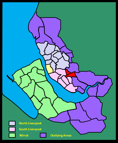
Childwall Village A view from the Trans-Pennine Trail (the disused Cheshire Lines railway known nowadays as the Liverpool Loop Line) showing All Saints church against the backdrop of Childwall Woods. Childwall is an ancient settlement, mentioned in the Domesday Book in 1086. The name denotes the field of the well or spring in old Norse. Childwall Well (also known as the Monks Bath) was situated bout 420 yards (380 m) north of the church according to the 1851 map (near the foreground of this picture). It was a strong cold spring at this time and the stream from it used to flow into nearby Childwall Brook. It dried up around 1840 as a result of water extraction nearby. However, in 1965 workmen removing and rebuilding the sandstone wall at the corner of Well Lane and Childwall Lane (opposite the church) unearthed a well about 5 feet (1½ m) in diameter with three steps leading down to it. It was clearly ancient. Could this have been the source of the name? |
 |
| Childwall by Samuel Derrick (1760) The roads from Liverpool are deep and sandy; consequently rather unpleasant; but the views are rather extensive, particularly from a summerhouse on Childwall Hill, about three miles distant, where you have a prospect of fifteen counties and a good view of the sea. In the skirts of this hill are several small villages with gentlemen's seats scattered about, well covered and for the most part delightfully situated. |
||
| Childwall in Fragments (1817) by Matthew Gregson The views from the neighbourhood of the church, from the hall, Gateacre, and as far as Woolton Hall [...] are extensive and particularly fine. On the west are seen with more distant eminences, Aughton Hills, near Ormskirk, traversing a line of country to the north-east. The prospect from Prescot to Farnworth terminates on the south-east with a distant view of the ruins of Halton Castle - now fast mouldering away - a range of hills beyond, and Norton Priory. [...] A large portion of the Mersey water forms one of the features of this scene, and gives great interest to a landscape that extends nearly fifteen miles. [ ...] This highly cultivated vale is interspersed with more churches than are usually seen at one view in Lancashire. |
||
| Childwall in Lewis's Topographical Dictionary of England (1848) Childwall Hall [...] is in the castellated style, after a design by Nash; the park and grounds are in beautiful taste, and the scenery forms a panorama almost unrivalled in beauty and extent. The church has some early English piers and decorated windows, but the greater portion is of modern date: the tower is handsome, surmounted by a spire, and of neater stonework than the rest of the edifice. |
||
| Childwall in the Victoria History of the County of Lancaster (1907) Childow is the local pronunciation [not any more!]. The township of Childwall is principally situated on the slope of a low hill, the highest point of which is 223 ft. above sea-level, commanding an extensive panorama of a wide, flat plain lying to the east. The district has an agreeable park-like appearance, with plantations and pastures, diversified with cultivated fields, where crops of corn, turnips, and potatoes are raised. There are but few dwellings, besides the hall and the houses which cluster about the church. [...] The Cheshire Lines Committee's Railway from Manchester to Southport passes through the centre of the township, and there is a station in Well Lane, about a quarter of a mile east of the church. [...] Well Acre is the name of a field in Well Lane just below the church. Another well or pool at the bottom of the slope to the north-east of the church was known as Monk's Bath; it was well protected by an interior four-sided wall of masonry, and a stream from it used to flow into the Childwall Brook a short distance away. |
||
 |
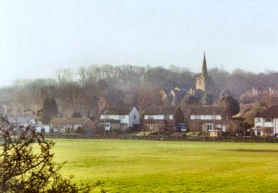
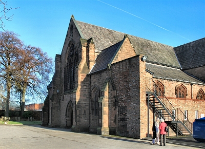
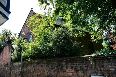
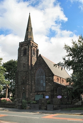
All Saints Church, Childwall There was probably a now demolished chapel on the site of this beautiful sandstone church in Childwall Village in the 11th century and some of the building materials have Norman or even Saxon origins. The current name is probably of relatively recent origin; a document from the 14th century suggests that the church was dedicated to St. Peter at that time. It is Liverpool's oldest parish church and the only one with mediaeval origins. The oldest part of the present structure is the north wall of the chancel with its window, an outer wall of the tiny original church. The porch is 15th century and has a Saxon stone in the west wall, probably a coffin lid, a ceiling carved with the stone heads of the four apostles and a 500 year old oak door. The nave with its north and south aisles was added in the 15th century and the sloping floor, which follows the gradient of the land, once continued into the chancel before it was levelled in 1851 (regrettably it now seems). The west tower with its spire was added around the same time as the nave. Thus the building stood until the early 18th century, when a major programme of extension and rebuilding began, which has continued to the present day. The tower and spire were demolised and rebuilt in 1810 following the disaster at St. Nicholas's church in Liverpool that year, when 25 people died following the collapse of the tower there. It is thought to have been relocated slightly further to the west. |
|
 |
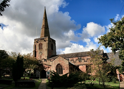
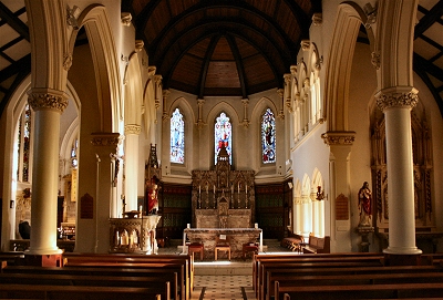
All Saints Church Interior, Childwall Looking down the 15th century nave with its sloping floor to the chancel, the original tiny 14th century church. |
|
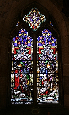 |
14th Century Window in All Saints Church, Childwall This window is in the north chancel wall, the outer wall of the original 14th century church (the glass is 19th century). |
|
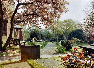 |
All Saints Churchyard, Childwall The churchyard at All Saints is a profoundly peaceful and atmospheric place. It was first mentioned in a document of 1386. One of the oldest epitaphs reads: 'Sacred to the memory of John Jones, who departed this life in his 95th year, June 1st, 1517. My sledge and hammer both decline, my bellows they have lost their wind, my fire is extinct, my forge decayed, and the dust in my vice is laid. My coals are spent, my iron is gone, my nails are driven, my work is done.' |
|
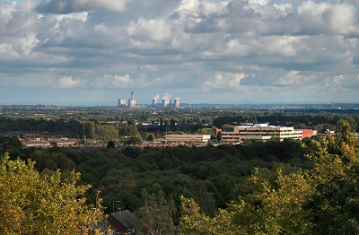 |
View from the Tower of All Saints Church, Childwall On open days it is possible to ascend the tower of All Saints Church by a very narrow twisting staircase, which gets even narrower towards the top (not for the claustrophobic). From the top there are superb views all around. In clear conditions St Mary's Prescot, St Mary's West Derby (and five other church spires) and Winter Hill in the Pennines are all visible. This is the view to the east, with Fiddler's Ferry power station prominent. |
|
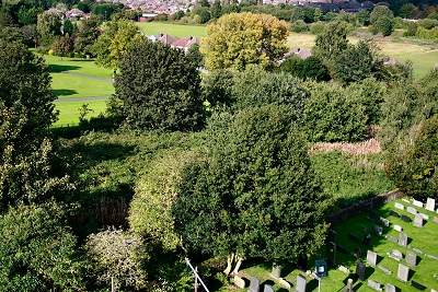 |
The Bloody Acre, Childwall This field alongside All Saints church, which has never been built upon, has been known as The Bloody Acre for centuries. It apparently takes its name from a Civil War skirmish of 1640 (also known as the Childwall Riot) between new landowners and adherents of the church. I understand that cannonballs have been unearthed in the area. |
|
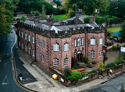 |
The Childwall Abbey, Childwall The Childwall Abbey Inn has been known by this name for at least a century, but its origins have been much disputed. It is most likely a renovated chapel, probably the Chapel of St Thomas the Martyr, which dates back to 1484. A remaining portion of the old walls bears witness to its great antiquity. The inn has associations with distinguished actors of the past who have stayed there; many have scratched their names on the old windows of the room that faces the church. Childwall Hall, a mock-mediaeval castle that was demolished in the mid-20th century, used to stand nearby; it also sported the local penchant for turrets (see also All Saints church). The Childwall Abbey is now a fine pub, atmospheric and original. Have a look for the mediaeval-style, high backed, elaborately carved, oak chair - it makes up in grandeur for what it lacks in comfort. |
|
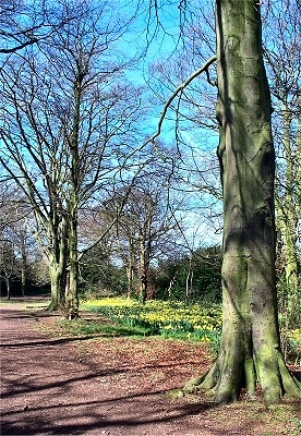 |
Childwall Woods The woods were originally part of the grounds of Childwall Hall and are ornamental in origin with a mix of species including English Oak, Sweet Chestnut and Beech and an extensive native Bluebell population. The adjacent Childwall Fields area is a noted butterfly habitat and 16 species have been recorded. Within the woods, the old carriage drive up to the hall (itself now demolished) is designated as a Regionally Important Geological Site for its exposed sandstone faces. |
|
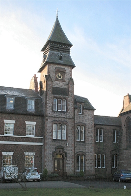 |
Eton House, Childwall The original two-storied Eton House was built in 1776 as a boarding school for boys for Hezekiah Kirkpatrick, a Unitarian minister and schoolmaster. It was bought in 1786 by Lord George Murray, who was keen on horses and hunting and built spacious stables to the west of the house. He in turn sold the property in 1797 to the Unitarian Dr. Peter Crompton, whose name survives in nearby Crompton's Lane. He and his family lived in there until 1843. Apparently Samuel Taylor Coleridge and his family were regular visitors and Robert Southey came in 1801. On Crompton's death, the house and surrounding lands were bought by Liverpool timber merchant and catholic Henry Sharples and shared with his cousin Bishop James Sharples. Henry built the large house Oswaldcroft next door and lived there until 1874. James Sharples and George Brown (later bishop of Liverpool) made the house their official residence and in 1845 erected a chapel. The complex is now known as Bishop Eton. |
|
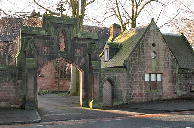 |
Bishop Eton Lodge and Gateway | |
 |
The Church of Our Lady of the Annunciation, Bishop Eton Bishop Eton originated as Eton House. It passed through various hands until It was bought in 1843 by Liverpool timber merchant and catholic Henry Sharples, who shared it with his cousin Bishop James Sharples. Sharples and George Brown (later bishop of Liverpool) made the house their official residence and in 1845 erected a chapel to a design by the celebrated father of the Gothic revival Augustus Welby Northmore Pugin. The Redemptorists took up residence in 1851 and demolished the chapel to build the present red sandstone Church of Our Lady of the Annunciation to a design by the architect's son Edward Welby Pugin. Parts of the original chapel, including some of the windows, were reused in the new church, which was opened in 1858. The complex is now known as Bishop Eton, the seat of the Roman Catholic Parish of the Redemptorist Fathers and Brothers. |
|
 |
The Church of Our Lady of the Annunciation Interior Among the windows preserved from the original chapel of Bisop Eton are one of St. Edward the Confessor in the first bay of the north aisle, one of St. Oswald in the opposite bay of the south aisle and a third, of rather Moorish design, at the west end of the north wall. The west window of 1920 represents the Last Judgement. The chapel to the northeast of the sanctuary is now the Shrine of Our Lady of Perpetual Succour, where there is a copy of the original icon in the Church of Sant'Alfonso in Rome. A fire in 1973 destroyed the gallery, organ and the entire roof, which had to be reconstructed. |
|
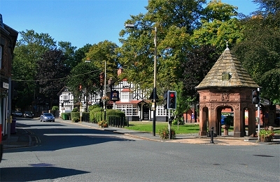 |
Gateacre Village The area now known as Gateacre Village is historic, though the name itself is not ancient (apparently is was first used in the 16th century). This crossroads at the centre of the village is shown on 18th century maps and the nearby pubs, such as the Black Bull opposite, would have been around in some form in those days. The road from left to right is the old packhorse trail from Hale to West Derby, which predates Liverpool itself. The oldest buildings now are partially 17th century. On the right is a drinking fountain and memorial of 1883 to John Hays Wilson, chairman of the Liverpool Water Committee. An attractive spot, where 18th century sandstone blends felicitously with 19th century mock-Tudor. Present day Gateacre was partly included in the earlier districts of Little Woolton (along with parts of Childwall) and Much Woolton. |
|
| Gateacre in Lewis's Topographical Dictionary of England (1848) This place is beautifully situated in a well-wooded vale, and is adorned with several gentlemen's residences. In the village is a Unitarian place of worship, built in 1698, which has an endowment of 20 acres of land, with a house for the minister. The accomplished William Roscoe attended the chapel. |
||
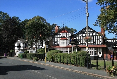 |
The Black Bull, Gateacre In the 18th century, Gateacre was likely a stopping-off point for travellers across the region and both the Black Bull and the Bear and Staff opposite (originally the Bear and Ragged Staff) had their origins. |
|
 |
Gateacre Chapel The plain sandstone Unitarian Chapel of Gateacre was built in 1700 for the local English Presbyterian congregation. |
|
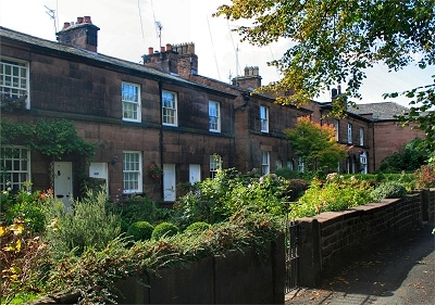 |
Cottages, Gateacre Early 19th century cottages in Gateacre Village. |
|
 |
St. Stephen's Church, Gateacre St. Stephen's was designed by Cornelius Sherlock completed in 1874. It has a notable large-scale stained glass west window by William Morris and Edward Burne-Jones. |
|
 |
Church Cottages, Gateacre The attractive Church Cottages of 1872 were, like the adjacent St. Stephen's church, designed by Cornelius Sherlock. |
|
| Little Woolton and Gateacre in the Victoria History of the County of Lancaster (1907) The greater part [of Little Woolton] consists of level country under mixed cultivation, having an open and pleasant aspect. A smaller portion on the west lies on the slope of a ridge, which rises to 285 ft. above sea-level. The village of Gateacre, which lies partly in Much Woolton, occupies the south-west side, and is nicely situated in the midst of trees and gardens. The roads are good, and hedged with hawthorn trimly kept. Altogether the township wears the prosperous, respectable look of a district removed from the smoke and murk of the city, with its feet set on the edge of the country. [...] Gateacre gives its name to a station on the Southport branch of the Cheshire Lines Committee's railway, which crosses the centre of the township. Netherley lies on the eastern border, and gives a name to the brook which bounds the township at that side, and to the bridge on the Tarbock Road crossing this brook. [...] In the extreme western corner of the township, serving as mere stones, are the ancient Calderstones, with 'ring and cup' marks. In the map of Elizabeth's time, made to illustrate the dispute as to Wavertree and Allerton boundary, these stones are called Caldway stones, Roger stones, or dojer stones; a Roger stone is marked separately to the south-west of the Calder stones. |
||