|
|
|||||||||
|
|
|||||||||
| Home Page: merseySights |
Home Page: allertonOak |
|||
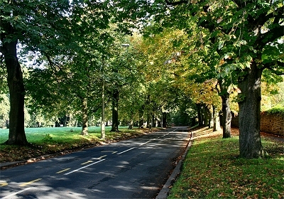 |
Aigburth
Vale Aigburth Vale is the name commonly associated with area around the dip in Aigburth Road at Jericho Lane. However it is also the current name of the road along which the original village of Aigburth grew up. The name refers to the valley of the old river known originally as Osklesbroke, which dried up after the construction of the lake in Sefton Park. The village was located on the south-east bank of the Osklesbroke on the slopes leading up to Mossley Hill, but nothing remains of any pre-nineteenth century buildings. The name is Viking in origin, meaning hill of oak trees, not inappropriate at the leafy northern end of the road. |
|
| Aigburth in Lewis's
Topographical Dictionary of England (1848) Aigburth is a wealthy and fashionable district extending along the banks of the Mersey, and studded with the noble mansions and splendid villas of the Liverpool bankers and merchants, the salubrity of the air and the delightful scenery inviting their residence here. The land is beautifully undulated, and there are fine views of the river, the Welsh mountains, the county of Chester, and the ocean. |
||
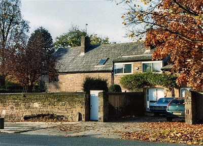 |
Stanlawe
Grange, Aigburth Stanlawe Grange, probably dating from 1291, is Liverpool's oldest extant building, though it has been modified many times over the centuries and is now two houses. The land around here was gifted to the abbot and monks of Stanlawe Abbey (founded 1178) on the opposite side of the Mersey by one Adam de Gerstan (died 1265). The property consisted originally of barns, monks' quarters and a granary, with a separate hall (Aigburth Hall, on a site on the opposite side of the road). By 1550, after the dissolution of the monasteries, the property had passed to the Catholic recusant Tarleton family and then, by the late 17th century, by marriage to the equally devout Catholic Harringtons. Both families were regarded with extreme suspicion by the Sheriff of Liverpool. After many changes of ownership, the property was in a poor condition by the early 19th century and Aigburth Hall was demolished in the 1840s. Conversion into the two present dwellings was undertaken in 1967. |
|
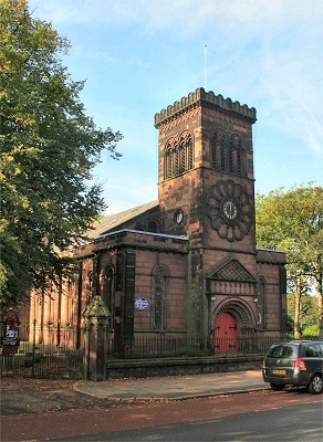 |
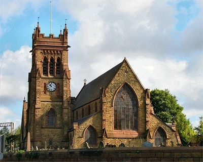
St.
Anne's Church, Aigburth St. Anne's church was built in 1836-7 in an unusual early 19th century Norman Revival style. |
|
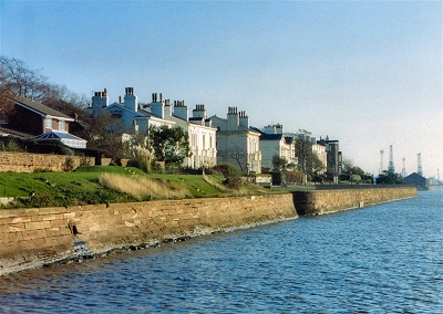 |
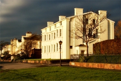
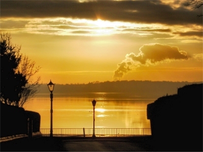
The
Esplanade, Grassendale Grassendale and Cressington Parks, begun in 1845 and 1846, respectively, were the second and third of Aigburth's walled riverside housing developments. The plots here were smaller than in Fulwood Park and the building plans more modest, but this remains an exclusive area with plenty of old world charm along its leafy roads. The entrance gates and lodges are on Aigburth Road. The Esplanade, which they share, has a fine location with glorious views over the River Mersey. The elegant housing here, in Regency style, is typical of much of the parks. |
|
 |
The
Esplanade, Grassendale My thanks to Brendon Cox for this picture. |
|
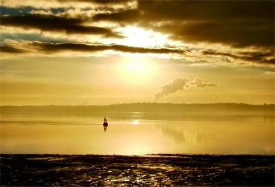 |
The
Mersey at Grassendale Park My thanks to Brendon Cox for this picture. |
|
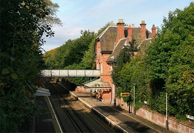 |
Cressington
Station, Cressington Park This station building, originally Cressington & Grassendale Station when it opened in 1864, is a very attractive example of the stations built by the Cheshire Lines Committee on its Garston and Liverpool line. |
|
 |
Cressington Park, Aigburth | |
 |
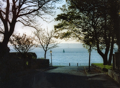
Cressington
Park, Aigburth My thanks to Brendon Cox for this picture. |
|
 |
St.
Michael's Church, Garston The site of St. Michael's church of 1875-7, now wedged between a vast gasometer and a railway line, has a lot of history. It stands next to the site of an 18th century chapel, which in turn replaced one of at least 1225 dedicated to St. Winifred. |
|
| Fishing in the Mersey around
Garston, early 18th century. Thomas Patten of Warrington, writing to Richard Norris of Liverpool, says: 'You very well know the mischief that is done on the River Mersey, or at least have frequently heard what vast numbers of salmon trout are taken so as to supply all the country and market towns twenty miles round, and when the country is cloyed and they cannot get sale for them they give them to their swine. Your brother did formerly take three or four salmon a week at a fishing in or near Speke, but of late hath taken very few or none, of which he hath complained to me, and he imputes this loss to the destruction of the fry'. |
||
| Garston in Fragments
(1817) by Matthew Gregson About twenty-five years ago the chemical preparation for bleaching was manufactured here by Mons. Bonnel, on its early introduction into England, but the work has long since been discontinued. Vitriol works were also carried on for a short time at Garston. [...] There are a few fishermen here; but formerly, it is said, great quantities of fish were caught on the Liverpool shore. [...] Many fishgarths, we are sorry to find, are stalled down from Runcorn Gap to Liverpool, viz. at Runcorn, Hale, Garston, and Toxteth Park. It is to be lamented that so much small fry is destroyed, particularly during spring tides; as their food being thus taken away, the large fish are prevented from visiting our shores as usual. |
||
| Garston in Lewis's
Topographical Dictionary of England (1848) The township, which is beautifully situated on the Mersey, abounds with gentlemen's seats and villas, and commands fine views of the Cheshire hills and Welsh mountains. On the banks of the river are extensive works for refining salt; and at Otterspool is a rivulet flowing into the Mersey, near which is an oil-mill. An act was passed in 1846 to enable the St. Helen's Canal and Railway Company to make docks here, and construct a railway to Garston, nearly 7½ miles in length. |
||
| Garston in the Victoria
History of the County of Lancaster (1907) The township, bounded on the south-west by the River Mersey, has an area of 1,625 acres. The division between Garston and Toxteth is marked by Otterspool, a name now given to the waters of the Mersey, where a brook flowing through Toxteth falls into that river. Another brook flows - or did flow - diagonally through the township; and a third used to pass through the village and discharge by a narrow gorge into the Mersey; a small portion is still visible. The country is flat, covered with the pleasant suburban colonies of Aigburth and Grassendale, with streets of houses set in flowery gardens, many running at right angles to the principal main roads, and leading down to the river bank. Grazing fields are scattered amongst the houses and streets, especially near the river. Garston itself is a seaport town, with docks, iron and copper works, and large gas works. On the outlying land are cultivated fields where some crops are grown. These include potatoes and corn. Altogether the district is a curious mixture of industrial, agricultural, and residential features. [...] The Liverpool tramways reach as far as Garston. The Cheshire Lines Committee's railway passes through the township, and has stations at Aigburth, Otterspool, Mersey Road (close to the Liverpool cricket ground), Grassendale (Cressington Park), and Garston. The sugar works (glucose) have ceased work owing to the cases of arsenical poisoning traced to them. Formerly there were salt works which had been removed from the Salthouse Dock at Liverpool, and at one time the fishery was of importance. |
||
| Garston in Liverpool
(1907) by Dixon Scott Viewed de profil - as, for instance, from the River - [Garston] would appear to be furnished chiefly with gasometers. The concomitants of gasometers are as invariable as those of race-meetings: Garston is grimy. Considered more closely, however, it breaks up a little, and reveals here and there some wholly pleasant incidents. And on its inland side it yields very gracefully to the influence of the shadowed lanes from Allerton. The rib that joins it to the centre, sweeps [...] through an easy, spacious district of private parks and well-preserved, middle-aged mansions. |
||
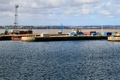 |
Garston
Stalbridge Docks A small dock, the Salt Dock, was first built at Garston in 1793 for the local saltworks. It was at the mouth of a brook flowing down into Garston past St. Michael's Church, just west of the line of Church Street and Dale Street (where there were a wooded section called The Dingle and a Dale House before 1900). The lower reaches of the river supported a number of dams, pools, mills and fisheries from mediaeval times. The salt works refined rock salt from Cheshire brought down the River Weaver. The area started to be filled in with the coming of the railways and the building of the first enclosed docks in the middle of the 19th century. Garston is now a major shipping and container port. |
|
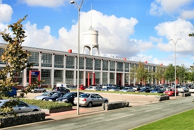 |
The
Matchworks, Garston The Bryant and May match factory was built in 1919-21. The company became famous for the Swan, Pilot, Vesta and England's Glory brands. It was the last match factory in the UK, continuing in use until 1994. It has now undergone extensive redevelopment as the Matchworks office complex. One of my favorite commercial buildings in the town. |
|
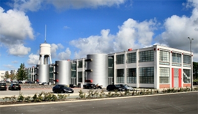 |
The
Matchworks, Garston The Pevsner Guide describes: 'six silvery, fat and corrugated cylindrical service pods with sinister slot windows - very retro sci-fi. This is a conversion that successfully plays to the building's original aesthetic strengths with alterations largely of wit and confidence'. |
|