|
|
|||||||||
|
|
|||||||||
Home Page: merseySights  |
Home Page: allertonOak  |
|||
 |
| CLICK A BOOTPRINT FOR A RELEVANT WALK - LINKS TO OTHER SITES AT THE BOTTOM OF THE PAGE |
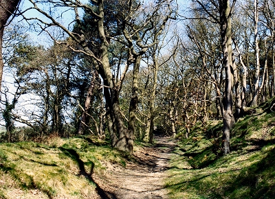 |
Storeton Wood, Storeton Storeton Wood was the site of sandstone quarrying from Roman times until just after the World War II. The name appeared in the Domesday Book, but evidence of earlier inhabitants came in the shape of 200 million year old footprints of a cheirotherium, a kind of quadruped dinosaur, found in the rock in 1838. In that year a tramway was constructed, a short section of which remains in the wood, to ease the transport of stone to the River Mersey at Bromborough Pool. The stone was used for many notable local buildings, including those in Hamilton Square (Birkenhead). The quarries were filled in after the war with rubble from the blitz and the Mersey road tunnel excavations. There is now little remaining evidence in this lovely strip of woodland with its views across mid-Wirral to the Welsh hills. |
 |
| Storeton in Lewis's Topographical Dictionary of England (1848) Here are very extensive freestone-quarries; the stone has acquired great celebrity, and many of the edifices of Birkenhead and the neighbouring country have been built of it. A plain of considerable extent, party in this and partly in an adjacent township, has lately been used as a race-course, and the races have been attended by numerous visitors. |
||
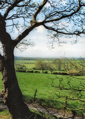 |
Rural Mid-Wirral from Storeton Wood, Storeton It is now thought likely that Storeton Wood and adjoining Bebington Heath (now Bromborough Golf Course) were the location of the important Battle of Brunanburh (Bromborough) in the year 937 in which the English King Athelstan defeated an alliance of Dublin Vikings and Celtic Scots. Although some of the local Viking community were probably drawn into battle on the side of their Irish cousins, the event appears to have had relatively little long-term impact upon the Scandinavian culture of Wirral at that time. Both sides were considerably weakened by the bloody conflict and withdrew soon afterwards. |
|
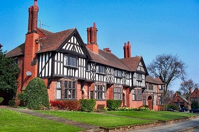 |
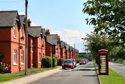
Houses on Park Road, Port Sunlight The remarkable Port Sunlight village was the brainchild of William Hesketh Lever (1851-1925). His commitment to providing decent accomodation for his workers arose from the 1840s movement for housing and sanitary reform that lead to the 1851 Housing and 1875 Health Acts, but went much further. His particular vision was a combination of earlier model housing schemes with the principles of 18th century landscape design as transmuted in many existing Regency suburbs and spa towns. To quote William Lever: 'It is my hope [...] to build houses in which our work-people will be able to live and be comfortable. Semi-detached houses, with gardens back and front, in which they will be able to know more about the science of life than they can in a back slum, and in which they will learn that there is more enjoyment in life than in the mere going to and returning from work, and looking forward to Saturday night to draw their wages [...] Ten to twelve houses to the acre is the maximum that ought to be allowed [...] houses should be built a minimum of 15 feet from the roadway [...] every house should have space available in the rear for a vegetable garden [...] open spaces for recreation should be laid out at frequent and convenient centres. ' Reflecting upon the international influence of Port Sunlight is this quote by Hermann Muthesius in his book Das Englische Haus, 1905: 'If one wishes to obtain a quick and accurate appreciation of the achievement of contemporary English house-building, there is hardly a more comfortable means than by undertaking a journey to the factory village of Port Sunlight near Liverpool [where] the gates of a new world were first opened: in place of the dismal appearance of utilitarian buildings we were shown a new vision; in place of the misery associated with the barren rows of workers' terraces we find joyfulness and homeliness.' |
|
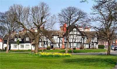 |
Houses on Lower Road, Port Sunlight William Lever was born in Bolton to a family of wholesale grocers, a business he duly entered. From 1884, he specialised in soap manufacture, setting up with his brother James Darcy Lever (1854-1910) as Lever Brothers. The extremely rapid growth in the business was only partly due to the superiority of the eponymous 'Sunlight' soap; more importantly, he introduced the small packets that we are now familiar with, attractively wrapped and imaginatively advertised using appropriate images from contemporary paintings. Lever diversified his business after the Word War I, particularly into margarine, and the 1930 merger with the Dutch Margarine Union led to the current Unilever empire. The site was on the north side of Bromborough Pool opposite Price's Village, from which Lever no doubt took inspiration. The land was unpromisingly marshy and crossed by three muddy tidal creeks, tributaries of Bromborough Pool. However, it was close to road, rail and sea routes. The factory was completed in 1889 on the site of the old Bebington Cement Works. The author of the original plan for the village is not known for certain. It may have been local architect William Owen, but at any rate William Lever had a big hand in it. Initially there were 24 acres (10 ha) for the factory and 32 acres (13 ha) for the village. Owen designed the factory, the first 28 houses and the entrance lodge in 1889-90. This original housing was that between the factory and the Dell. Bromborough Pool was dammed in 1902 and the Dell was the result of draining and landscaping the southernmost of the original tidal creeks; the bridge was constructed in 1894. The village site expanded gradually to the present 130 acres (53 ha). The final plans for the village as it now stands were due to Ernest Prestwick, a third year student in the School of Architecture at Liverpool University, who won a competition in 1910 run by the school and the Department of Civic Design; not many undergraduate dissertations have such influence! The other tidal creeks were mostly filled in by 1910 and correspond to the present green spaces along Lower Road and The Causeway. Where the street plan departs from a regular geometric pattern, it is because of these streams. |
|
 |
Christ Church, Port Sunlight The English gothic styled Christ Church, built of Helsby sandstone, was completed in 1904. It was initially non-denominational, an oddity that fitted with Lever's non-conformist views ('a church in whose worship all Christian people, except those of extreme views, could share'). The beautiful interior has some magnificent stained glass. It is now a United Reformed Church. |
|
 |
Hulme Hall, Port Sunlight Hulme Hall was completed in 1901 and named after Lever's wife and childhood friend Elizabeth Hulme. It was originally a girls' dining room capable of seating 1500. When a works canteen was established, it was used as a museum and art gallery until the completion of the Lady Lever Gallery. It has since been used for special functions and gatherings and was the venue of an early Beatles concert. |
|
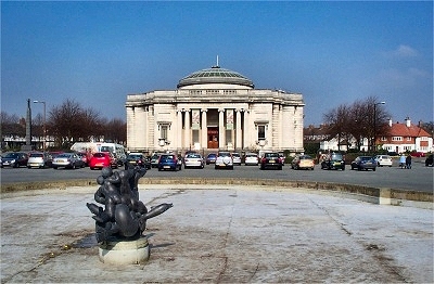 |
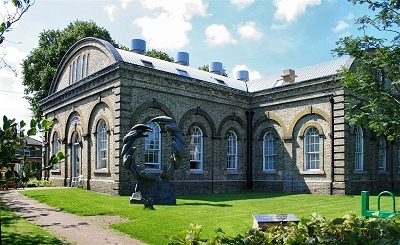
Lady Lever Gallery, Port Sunlight The subdued, classical Lady Lever Gallery, designed by William and Segar Owen in memory of Lever's wife Elizabeth who had died in 1913, and completed in 1922, is probably the finest building in Port Sunlight. Segar Owen described to Lever his concept of 'keeping a simple building with the entrances as the outstanding features [...] long lines giving this large building a low dignified appearance [that would] harmonise with the village, but at the same time stand out apart'. The fountain in front, of 1949, is by Charles Wheeler. The gallery reflects Lever's artistic preoccupations, with several rooms in the style of different periods and collections of sculpture, pottery, furniture, tapestries and paintings, most notably English Victorian art. Among some famous examples of the latter are Burne-Jones's lurid Tree of Forgiveness and Beguiling of Merlin, Rossetti's Blessed Damozel and William Holman Hunt's extraordinary Scapegoat. Among other artists represented are Turner, Constable, Gainsborough, Reynolds, Stubbs, Waterhouse, Millais and Sargent, and there is a nice portrait by George Romney of the peachy Sarah Rodbard. Note also Joseph Farquharson's perennial Christmas card favourite The shortening winter's day is near a close. A source of amusement, to me at least, is the painting Andromeda, by William Etty, unsurprisingly decried as pornography by his contemporaries. He later added chains to her to emphasise the classical over the visceral, which the caption writer for the gallery was not quite convinced had the desired effect. |
|
 |
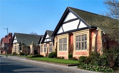
Park Road and the Lyceum The Lyceum was completed in 1896 and was originally a school and a venue for Sunday services; it is now a social club. |
|
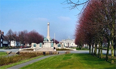 |
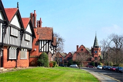
The War Memorial, Port Sunlight The War Memorial, by W. Goscombe John, was completed in 1921 as an unsentimental reflection on 'defence of the home'. It occupies a focal point of the village at the intersection of the Diamond and the Causeway. |
|
 |
The Diamond, Port Sunlight The Diamond is the central boulevard of the village, named from the original open space crossed diagonally by the tidal creeks. This space was extended into an 1,800 by 200 ft (550 by 60 m) mall with associated housing in Prestwick's plan in 1911-1913. This may have been inspired by American models; it is reminiscent of the Mall in Washington DC on a smaller scale, especially with the classical architecture of the Lady Lever Gallery at the northern end (admittedly not quite the Capitol). |
|
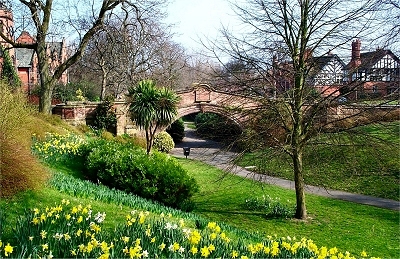 |
The Dell, Port Sunlight The Dell represents the landscaped remains of a large tidal creek that used to flow into Bromborough Pool. The bridge dates from 1894. The land on which the village was constructed was originally desolate marsh crossed by a number of such creeks. Where the street plan departs from a regular geometric pattern, it is because of these waterways. Bromborough Pool was dammed in 1902 and the other creeks had mostly been filled in by 1910. |
|
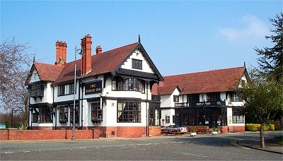 |
The Bridge Inn, Port Sunlight The Bridge Inn was built in 1900 and was originally a temperance hall, following Lever's belief in abstinence. Even so, it had become licensed by 1903. It was designed according to an idealised concept of the ancient English hostelry, with dining, tea and assembly rooms. |
|
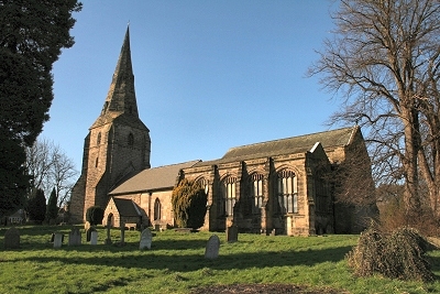 |
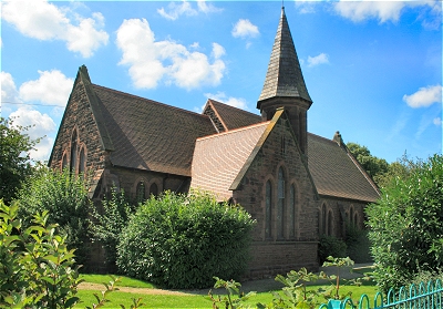
St. Andrew's Church, Bebington There was a church on this site before the Norman Conquest. Some of the stones, which are of sandstone from the Storeton quarry, survive in the south wall of the present church. The curve of the adjacent road follows the boundary of an ancient circular burial ground (Viking settlers believed that corners were hiding places for evil spirits). A new church was built in Norman times; the area was then known as Whitchurch from the creamy colour of the stone used. A tower was added during the first half of the 14th century, when other extensions were also undertaken. Part of the south arcade survives from the Norman church and the north arcade is a copy of this from 1847. The chancel and chapels were built in the 16th century in a contrasting Perpendicular style (the nave is mainly Early Decorated style). The final structure was to have been more integrated, but work was interrupted by the Dissolution of the Monasteries. The contrast is also evident inside: the east end has cathedral-like proportions and large windows, while the earlier part seems more like a mediaeval village church. |
|
| Bebington in Lewis's Topographical Dictionary of England (1848) The parish is situated on the banks of the river Mersey, and is intersected by the road from Neston to Birkenhead, and the railway from Chester to Birkenhead. [...] At Rock Ferry, in the parish, are several good mansions, some baths, and an hotel; and the neighbouring scenery is delightful. The church is a noble structure, partly Norman, and partly in the style that prevailed in the reign of Henry VIII; it suffered much by neglect and by injudicious repairs in past years, but has been recently restored, renovated, and considerably enlarged [...] and now presents one of the finest specimens of ecclesiastical architecture in the county. |
||
| Spital in Lewis's Topographical Dictionary of England (1848) In the reign of Henry III there was a chapel in the parish, dedicated to Thomas Becket, and it is probable that it stood in Spittal and was attached to the hospital in that hamlet, founded for lepers: no trace of either chapel or hospital now exists, except of the latter in the abbreviated name of Spittal. [...] Poulton Hall is situated on a gentle eminence, and is surrounded with good timber; the views from the mansion are bold and extensive, commanding the Welsh coast. |
||
 |
South View, Price's Village, Bromborough Price's Village, known also as Bromborough Pool Village, owes its origins to the philanthropist William Wilson, whose father and uncles developed a village called Wilsontown with good quality workers' housing adjacent to their family estate in Lanarkshire, Scotland, following the discovery of iron there. Wilson became a successful merchant importing goods such as tallow from Russia and decided to go into candle manufacture with his partner Benjamin Lancaster. The business was originally called Edward Price and Co. (a fictitious name) and their first factory was in Vauxhall, London. The Wilsons were a deeply religious family, concerned for the wellbeing of employees, especially children. The company sought to build good quality housing for its workers in London but could not buy any land. However, their second factory at Bromborough Pool (close to where most of their imports were landed) was a 42 acre (17 ha) green field site, where Price's also built a village, eventually of 142 houses with a church, school, institute, shop and library for its workforce. The village inspired to William Lever to build his own model village at nearby Port Sunlight in the 1880s. Here are the comments of John Nelson Tarn in his article The model village at Bromborough Pool in Town Planning Review, 1965: Bromborough [Pool]'s place in the history of the model community should be recognised more widely than it is today, for, although a small village at first, it was in reality the first garden village, with its open spaces, its gardens and planting. In these respects it was far in advance of anything built at that time. Only in the simple unaffected layout of the streets and the vernacular quality of the architecture does [it] suggest its early date. In the concept of space and density it was a forerunner of the garden city [...], and for its place in the history of enlightened factory management it merits our attention today. |
|
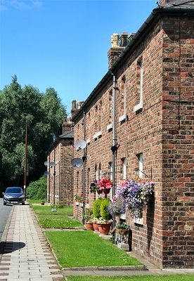 |
Manor Place, Price's Village, Bromborough When tallow, a purified form of beef or mutton fat, was the only cheap available alternative to beeswax for making candles (sputtering and smelly as it was), Price's immediately started to use coconuts subjected to a saponification technique. They were also able to refine tallow, vegetable oils, fish oil and industrial waste greases to produce a hard, pure white fat known as stearine, making candles that burned brightly without smoke or smell. Another innovation was a process for cleaning palm oil with sulphuric acid to create a new cheap source of fat. Price's initally made the mistake of not taking out patents, enabling the competition to benefit from their research. In 1847 the company became Price's Patent Candle Company, showing that it had learnt the lesson, and by 1858 held 114 patents for different candle manufacturing inventions. The village plan was devised by London architect Julian Hill with houses, initially short terraces and later semi-detached, on a grid pattern. The first houses to be built were on York Street. 32 houses were erected and the first resident moved in in 1854. Manor Place with 16 houses was built in 1856 and by 1858 there were 76 houses altogether with a population of 460. A second phase of building started in 1872 including a new road, South View, with 6 houses, six more being added in 1877. A third phase of building took place between 1896 and 1901 with new houses in Manor Place and South View. These later red brick houses may have been influenced by the architecture at Port Sunlight village. Further houses in Manor Road and South View were added in 1900. |
|
 |
Village Hall, Price's Village, Bromborough The public buildings are all in a row on York Street. The yellow brick village hall of 1858, designed by Julian Hill in a similar style to the original factory, which is now almost entirely demolished, was originally the school. |
|
 |
St. Matthew's Church, Price's Village, Bromborough Religion formed an integral part of village and factory life. There was no proper chapel initially in the village, although services and bible classes were supervised by the company chaplain. The villagers' petition to Price's for a new church in 1885 was accepted and the cost largely met by the company. The resulting, originally non-denominational, sandstone chapel was opened in 1890. It later became St. Matthew's church (Church of England). |
|
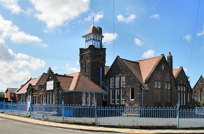 |
School House, Price's Village, Bromborough The sandstone replacement school was built in 1898. |
|
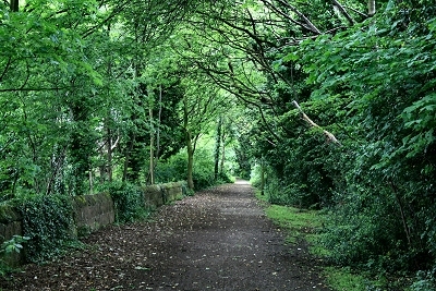 |
Path to Easham Woods, Bromborough | |
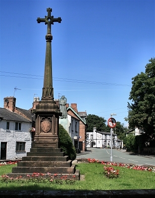 |
Eastham Village Cross Eastham is thought to be one of the oldest villages on the Wirral Peninsula and has been inhabited since Anglo Saxon times. The name derives from its location to the east of Willaston, which was originally the principal settlement. The original village is clustered around St. Mary's Church. |
|
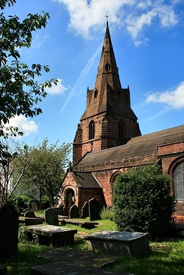 |
St Mary's Church, Eastham It is possible that there was a chapel at Eastham before the Norman Conquest. The manor of Estham, which then included Bromborough, was recorded in the Domesday Book of 1086. The chapel was probably built of wattIe and daub 'Iarge enough to cover the altar and to shelter the sacred elements from the rain and storm', as historian W.F. Irvine wrote in 1896. The north wall of the Stanley Chapel in the present church may be Norman, although the main building period seems to have been the 13th and early 14th centuries. The steeple was originally built around 1320 and rebuilt in 1752, the aisles in the 15th century and the south porch in the 16th century. A major restoration took place between 1863 and 1880. |
|
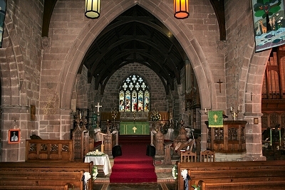 |
St Mary's Church Interior, Eastham | |
 |
Lych Gate at St Mary's Church, Eastham | |
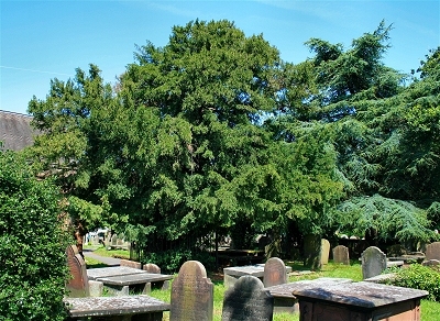 |
Yew Tree in the Graveyard at St Mary's Church, Eastham According to a nearby plaque, when in 1152 the Abbot and Monks of St. Werburgh received the Manor of Eastham, the villagers entreated the new owners 'to have a care of ye olde yew'. In 1808, members of the Royal Archaeological Society expressed the opinion that the yew may have been planted against the east end of the original timber framed chapel, which was in existence before the Norman Conquest. They said that the tree's exact age was not known but was possibly 1500 years. In 1988, David Bellamy and other experts certified that the tree was about 1600 years old. |
|
 |
View of Easham Village to the South The author Nathaniel Hawthorne, who was American Consul in Liverpool and lived in Rock Park, New Ferry, described Eastham in his English Notes as 'the finest old English village I have seen, with many antique houses, and with altogether a rural and picturesque aspect, unlike anything in America, and yet possessing a familiar look, as if it were something I had dreamed about'. |
|
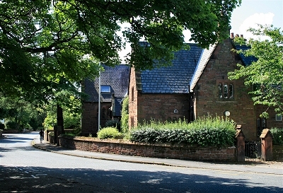 |
The Old School House, Eastham | |
 |
View of Easham Village to the North | |
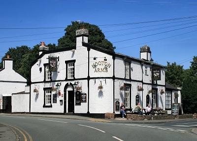 |
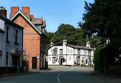
The Hooton Arms, Eastham | |
 |
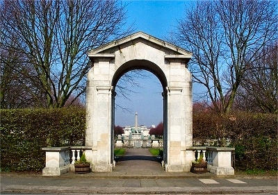
Eastham Ferry and The Tap The Eastham Ferry was once a favourite for travellers between Liverpool and Chester and as a day resort. A ferry service from Liverpool had operated since the Middle Ages and by the late 18th century up to 40 coaches arrived each day at a newly built pier. Paddle steamers arrived in 1816 and the Eastham Ferry Hotel was built in about 1845 on the back of this trade. The arrival of the railway line between between Chester and Birkenhead threatened to compromise business with the Woodside Ferry taking over more of the river crossings. To attract more visitors, landscaped pleasure gardens were added with ornamental trees, fountains, a zoo, an open air stage, tea rooms, a bandstand, a ballroom, a boating lake and a water chute. The opening of the Manchester Ship Canal by Queen Victoria in 1894 brought added prosperity to the area and a Jubilee Arch was built at the entrance to the gardens in 1897 to commemorate her Diamond Jubilee. The area's popularity declined during the 1920s and the last paddle steamer crossing took place in 1929. The pleasure gardens fell into disrepair during the 1930s and the iron pier and Jubilee Arch were later dismantled. |
|
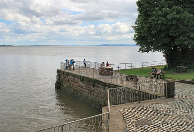 |
The Pier, Eastham Ferry | |
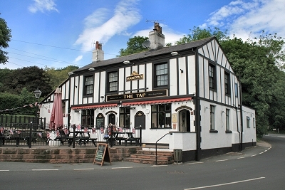 |
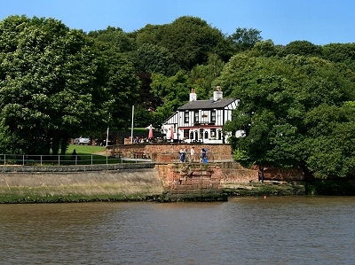
The Tap, Eastham Ferry The Tap is a nice old pub for a spot of refreshment followed by a wander down to the pier for great views over the Mersey. |
|
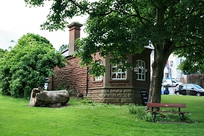 |
The Old Ticket Office, Eastham Ferry | |
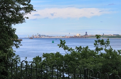 |
The Liverpool Skyline from Eastham Woods Following designation as a Country Park in 1970, Eastham Woods are once again a popular destination for outings. The area supports a wide variety of wildlife and contains some of the finest mature trees in Wirral, a haven for birds and animals. The cliffs on the riverside provide superb opportunities for viewing flocks of waders and ducks on the estuary. |
|
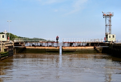 |
Eastham Locks Eastham Locks mark the start of the Manchester Ship Canal. They are the largest of five lock systems on the canal. A navigable waterway from the Mersey Estuary to Manchester was first proposed as early as 1660. From 1724 to 1734, construction work was undertaken by the Mersey and Irwell Navigation Company enabling boats of moderate size to make the journey when rainfall and tides permitted. The completion in 1776 of the Bridgewater Canal, followed in 1830 by the opening of the Liverpool and Manchester Railway, intensified competition for the carriage of goods. In 1872 the navigation was sold to the Bridgewater Navigation Company and had by then fallen into disrepair. In 1882 it was described as being 'hopelessly choked with silt and filth'. At the time, fees charged by the Port of Liverpool and the railway companies were perceived by Mancunians as excessive, perhaps the start of the rivalry between the two cities that lingers on good-naturedly (one hopes) to the present day. In 1882, a full-sized ship canal was proposed, giving Manchester direct access to the sea for its imports and its exports and much needed employment opportunites. Unsurprisingly, the idea attracted fierce opposition from the City of Liverpool and several railway companies, and the passage of the necessary enabling Act of Parliament was delayed until 1885. The estimated cost of construction was £5.16 million and the work was expected to take four years to complete. |
|
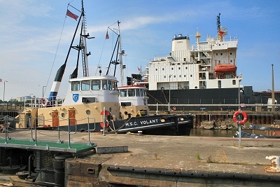 |
Tugboats at Eastham Locks | |
| Eastham in Lewis's Topographical Dictionary of England (1848) The parish is intersected by the Chester and Birkenhead road, the Ellesmere canal, and the Chester and Birkenhead railway, and is situated on the river Mersey. In the township of Eastham are 1205 acres, of a sandy soil. About a mile from the village is a ferry on the Mersey, where is an hotel of recent erection, with pleasure-grounds attached, an agreeable place of resort during the summer, the vicinity affording beautiful scenery. Sir William Massey Stanley has lately appropriated about 100 acres of land for building purposes; the land is divided into suitable plots of an acre or two each, after the designs of Mr. Clark Rampling, architect, of Liverpool, and villas are in progress of erection, which will add greatly to the importance of the locality. [...] The church is a large and handsome edifice of red stone, consisting of a nave, chancel, and aisles, with a tower and elegant spire. |
||
| Eastham in The Beauties of England and Wales, Vol II, Edward Wedlake Brayley and John Britton (1809) Eastham is a small vicarage, only singular from the vicar being entitled to all the fish caught in the river Mersey on Sundays and Fridays. The church consists of a nave, chancel, and side aisles, with a spire tower at the west end. Inigo Jones is reported to have been the architect, but the spire having become ruinous, was rebuilt about fifty years since. |
||
| Hooton in Lewis's Topographical Dictionary of England (1848) Hooton lies in one of the most pleasant situations of which the banks of the Mersey estuary can boast, and is shaded with venerable oak-trees, of a growth exceeding any on the shores of Wirrall. [...] The ancient Hall, a large timbered building, erected by licence from Henry VII, was taken down in 1778. The present mansion [demolished 1931] is built of stone from the Stanley quarries in Storeton, after designs by Wyatt, and is a beautiful structure, standing on a gentle eminence, and commanding an extensive view of the river, and of the entire coast of Cheshire and Lancashire. |
||