|
|
|||||||||
|
|
|||||||||
Home Page: merseySights  |
Home Page: allertonOak  |
|||
 |
| CLICK A BOOTPRINT FOR A RELEVANT WALK - LINKS TO OTHER SITES AT THE BOTTOM OF THE PAGE |
 |
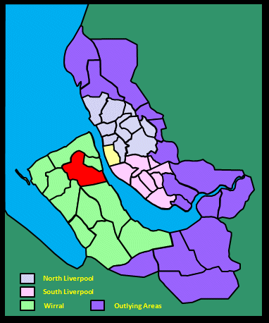
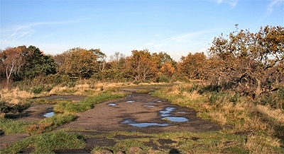
Bidston Hill Bidston Hill is approximately 100 acres (40 ha) of lowland heath, sandstone outcrops, mixed woodland and acid grassland, rising to 231 ft (70 m) above sea level. Although it is surrounded by the sprawl of Birkenhead and its suburbs, you are not really aware of this when there - tranquility reigns. The area is littered with points of historical interest as well as being a wildlife haven; it is a Site of Biological Importance (SBI) and a Regionally Important Geographical Site (RIGS). I am indebted to the leaflet Bidston Hill Heritage Trail put together by the Friends of Bidston Hill, which I have plundered for much of my information. |
 |
 |
Bidston Hill Bidston Hill is a designated Regionally Interesting Geological Site by virtue of its sandstone formations. The sandstone was deposited over 200 million years ago in the Triassic period when the land was a desert and located near the equator. |
|
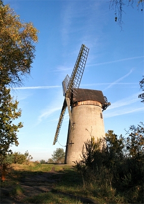 |
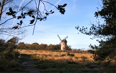
Bidston Windmill, Bidston Hill It is believed that Bidston Hill has sported a windmill since 1596. The sails of an earlier wooden peg mill broke loose in a gale in 1791 and the friction produced by the revolving wooden machinery caused a fire which destroyed the mill. The present brick tower mill, built in 1800, replaced the earlier mill and was used to grind corn to flour until 1875. It could produce over 100 lb (50 kg) of flour every 3 to 5 minutes. The top can be rotated through 360 degrees so that the sails can be moved to follow the direction of the wind. There are two doors to allow millers safe exit avoiding walking into the rapidly turning sails that could reach up to 60 mph (100 kph), a safety feature that, alas, was not always effective. The windmill was restored in 1894 but destroyed by a gale in 1927. It has been maintained Wirral Borough Council over the years. As of 2014, thanks to the efforts of the Friends of Bidston Hill, it will be open to the public again at certain times. |
|
| The view of Liverpool from Bidston Hill in Liverpool (1907) by Dixon Scott It would be from here, no doubt, in the old days, that the traveller from the south would catch his first glimpse of the River and the hamlet; it is from here that generation after generation of townsfolk have come to see their City in its bulk; it is here still that they bring the good stranger, hoping secretly that he will find their Liverpool a rather wonderful and alluring sort of place. And certainly it is from here, among this almond-scented gorse, that Liverpool builds up most perfectly into a visible entity. The City and its outposts draw easily together; the Dock Board Building makes an ivory nucleus; and Walton Church on the left, and Mossley Hill Church on the right, seem, in actuality, as they are in essence, but two organic incidents in the great design of which it forms the centre. The bird-song and the dumbness, the green spaces and the grey, the hid tragedies, the fair buildings, the lavish, roaring ways, are now merged wonderfully together, and, in their fusion, form one supreme attribute, nameless because it is unhuman. Smoke-scarves of her own weaving and vapours of the air binding her and her children together, Liverpool broods there in the sunshine, sole and indivisible, a splendid seaward-facing Presence. And the River flames at her feet. |
||
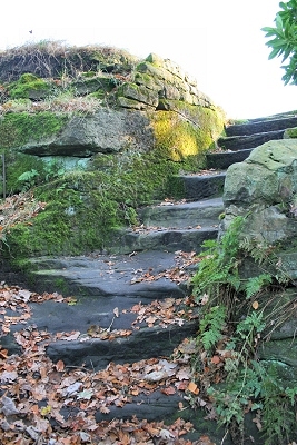 |
Penny-a-Day Dyke, Bidston Hill In 1407 this wall, known as Penny-a-Day Dyke, was built to create a deer park for deer hunting on the Stanley's private estate. The remains of the wall can still be seen just below the ridge from the Mill to the Observatory. It is locally thought that the name came from the payment given to workers for building it. |
|
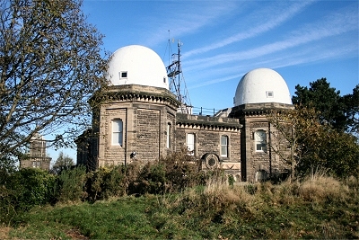 |
Bidston Observatory, Bidston Hill The observatory, visible from all around the region, was built in 1866, when it was relocated from Waterloo docks due to their expansion. The building was made using the stone mined during the creation of the cellars. Over the last 140 years the observatory has undertaken a diversity of tasks, many of groundbreaking importance. At the turn of 1929, the observatory and the Tidal Institute were amalgamated under the direction of Joseph Proudman. Bidston Observatory was deemed of national importance during the Second World War and predicted the tides for the D-day landings amongst other things. In 1969, the telescopes housed in the observatory, which were previously used to watch planetary bodies to calculate the exact time, were donated to Liverpool Museum. The exact time was needed for nautical navigation and was transferred to ships in the docks by the firing of the one o'clock gun, fired for the last time on the 18th July 1969. This was also the year that the Proudman Oceanographic Laboratory became an independent institute. The nearby Proudman Building opened in 1975. |
|
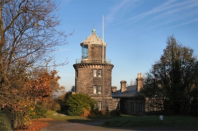 |
Bidston Lighthouse, Bidston Hill Bidston's first lighthouse was built in 1771 on Bidston Hill as a replacement for one situated a quarter of a mile out to sea at Leasowe. The 55 ft (17 m) octagonal tower with five floors was the furthest inland of any lighthouse in Britain, the ground elevation of 180 ft (55 m) making up for this. After a century's service the lighthouse was demolished and the current lighthouse (four floors with a circular tower) and cottages were built from local sandstone in 1873. The lamp shone until 1913, when it was no longer needed because of advances in navigation buoys. In 1763 a signalling station was built near to the location of the lighthouse and functioned using flagpoles as a complicated early warning system. As merchant ships rounded the Point of Ayr or sailed past Formby point the ship would be spotted and identified. Flag runners were employed to watch for ships and had 11 minutes to raise the correct company's flag on the correct pole, followed by the correct cargo flag. This enabled supervisors in the docks to ready their work force to off-load the ship. In 1771, the system was updated when the first lighthouse and semaphore station was built. It formed part of the chain of semaphore signals along the North Wales coast. A signal could be sent from Holyhead to Liverpool in only 8 minutes and meant that employers and dock workers had a little longer to organise offloading the cargo. |
|
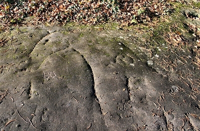 |
Horse Carving, Bidston Hill This carving, almost life size, has been carved into the rock using a 'pecking' technique. The horse is partly worn away, but the head and neck can still be seen. The circular carved device in the horse's neck may be a symbol depicting the sun. The carving is oriented towards sunrise at the equinoxes, which suggests that the horse may have some solar significance. Greek, Latin, Norse and Hindu mythology all consider horses important in the rising of the sun. It is difficult to age reliably. |
|
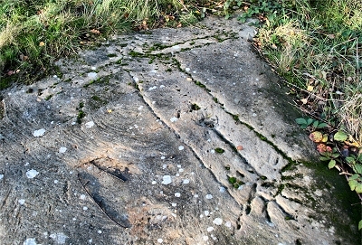 |
Sun Goddess Carving, Bidston Hill Probably the oldest man-made feature on Bidston Hill is this four and a half foot long carving of the 'Sun Goddess' in a human crucificial form. Its name refers to the sun ray design at the feet, which point roughly towards the rising sun at midsummer. It appears to have been re-cut at some point in the past, but has retained much of its original detail. The origin of this carving is shrouded in mystery but it is believed to be Norse Irish in origin and it has been suggested that it could be as old as late 9th century. |
|
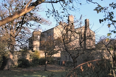 |
Bidston Hall, Bidston Most of the house was built around 1595 by Henry, the 4th Lord Stanley, Earl of Derby. The Hall has had an unusual past, being seized in the Civil War when the 7th Earl, James, refused to recognise Cromwell's authority and fled to the Isle of Man, also owned by the family, to fight to re-instate the monarchy; that backfired on him, as he was beheaded at Bolton in 1651. It is also recorded in the Hall's history that one of Charles I's illegitimate sons hatched a plot to claim the throne from Bidston Hall. There was also scandal brewing for a number of years between the 'Bard of Bidston', Lord William Stanley, and William Shakespeare. It seems that they were once friends (Lord Stanley was noted as the Bard's patron) but that their relationship became a less than happy one. Shakespeare was invited into Stanley's troupe of players and playwrights but it seems that Lord Stanley was not at all impressed by Shakespeare and remarked that the Bard 'was not all he was made out to be'. He insisted that Shakespeare had plagiarised his work, or at least borrowed heavily from his experiences. Whatever the case it seems clear that by the end of their acquaintance there was no love lost between them. |
|
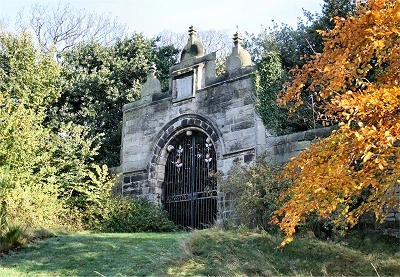 |
Bidston Hall Gates, Bidston | |
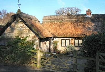 |
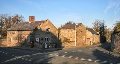
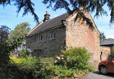
Tam O'Shanter Cottage, Bidston Hill This cottage, constructed from local materials, is about 300 years old and got its name in 1837 when Richard Lea, the occupier at the time, embellished the buiIding with a carved stone slab depicting a scene from Burn's poem of that name. Tam O' Shanter farm covered approximately 6 acres (3 ha) in 1840. The building burned down in 1954; the roof was destroyed by vermin in 1965 and burned down again in 1975. It was saved from demolition by the Birkenhead History Society. In May 1977 the farm accepted its first school visit and in 1986 the Wirral Urban Farm Association was formed to develop the four acres (2 ha) around the cottage as an urban farm, open to visitors. |
|
 |
Bidston Village The old village of Biston is today little more than a few ancient cottages, farms and St. Oswald's church, nestling at the foot of Bidston Hill, but it has a great deal of charm, helped by its isolated location. These cottages were once the Ring O'Bells Inn, which was closed down in 1868 for harbouring excessive drunkenness. |
|
| Bidston in Lewis's Topographical Dictionary of England (1848) On an elevated site is a lighthouse, which was purchased by the corporation of Liverpool, under an act obtained in 1762, and is supported by a duty levied on all vessels sailing to and from that port. Bidstone Hall, an ancient mansion, was a seat of the earls of Derby, and is said to have been a favourite residence of the Earl William, chamberlain of Chester in the reign of James I. [...] [There] are extensive views embracing the Welsh mountains and river Dee, westward; southward, the county of Chester; eastward, the Mersey, Liverpool, and Everton; and northward, the Channel, bounding the horizon. |
||
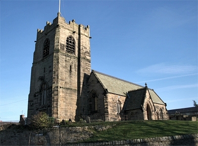 |
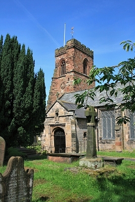
St Oswald's Church, Bidston There is evidence of earlier curches on this site going back to the 12th century, when Birkenhead Priory was founded, or earlier. The church was rebuilt in the 13th century and the tower added in the early 16th century. This tower survives but the remainder of the present building dates mainly from the rebuilding of 1855-6. |
|
| Bidston in Recollections of Old Liverpool (1863), an anonymous author recalling the mid-18th century The road to Bidston was a rough, rutted way, and the land was for the most part marshy between Woodside and Bidston, and the country looked very desolate, wild, and rugged. There were some pretty walks over the fields. There was one from Holt Hill to Oxton which I was very fond of. When the weather was fine I have had many and many a pleasant ramble over land where now houses show themselves in hundreds, nay, thousands, and where I have gone bird-nesting, and picking wild flowers, and mushrooming in their season. Lord! what changes I have seen and yet live to see. |
||
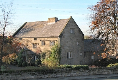 |
Church Farm, Bidston Church Farm, opposite the church naturally enough, dates from the 17th century. |
|
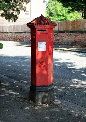 |
Early Victorian Pillar Box, Claughton This rare example of an early Victorian pillar box is in Alton Road. |
|
| Claughton in Lewis's Topographical Dictionary of England (1848) Claughton contains 575 acres, a large portion of which is converted into a public park and villa grounds [...]. The area [of the park] consists of 180 acres, laid out in admirable taste by Mr. Paxton, with every variety of landscape-gardening, including plantations of shrubs, flower-beds, verdant vales, picturesque lakes, ornamental bridges, and serpentine walks, with extensive drives, cricket and archery grounds, &c. A margin of 350,000 yards of land is available for sale to erect villas, and 114 acres are dedicated to the public for their free use and enjoyment for ever. [...] The park entrance is through a handsome archway for carriages, and two minor archways for foot passengers; on each side are uniform lodges, two stories in height, and built of the purest freestone: the noble architectural appearance of the whole, presenting a fine specimen of the Ionic style, is deservedly admired. Oxton Hill lies to the south of Claughton. Comparatively but a few years ago, it was a barren heath; it is now, to a great extent, covered with fine houses and villas, with gardens, fields, woods, and pleasure-grounds, and is, in fact, a village of itself. The air in this elevated locality is extremely salubrious, and the prospect from almost any point uninterrupted and delightful, embracing a vast extent of land, and town and marine scenery. |
||
 |
Oxton Hall Cottage, Oxton This lovely stone cottage dates from about 1660 and is the oldest remaining building in Oxton. |
|
| Oxton in Lewis's Topographical Dictionary of England (1848) The township is situated on a bold eminence, commanding views of the river Mersey, Liverpool, and the high lands of Lancashire; and comprises 650 acres, partly a sand and partly a clay soil, with a substratum of sandstone, of which there are some good quarries. In 1821, Oxton is described as being a dreary and barren waste. It has since been inclosed, and is now studded with residences, which are yearly increasing in number, owing to the liberal grant of building-leases for a fixed term by the Earl of Shrewsbury; of this circumstance, numerous respectable persons from Liverpool have availed themselves, and the commanding position of Oxton, which can hardly be exceeded, and its proximity to Birkenhead and the ferries, seem likely to insure a continuance of prosperity. |
||
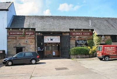 |
The Saddle Club, Prenton The Saddle Club and neighbouring buildings are all that remains of the old village of Prenton, now engulfed by post-war suburbs. It was originally part of Lower Farm, tied to nearby Prenton Hall, which is listed in the Domesday Book. Before that it was a winter shelter tucked down below a shallow ridge. It became a small mill and eventually a full working farm, in which form it survived until the late 1950s. It then became a riding stables and in the 1970s was divided into separate properties. |
|
 |
Holy Cross Church, Woodchurch This beautiful church is located in a tiny time warp at the centre of the large post-war suburban development of Woodchurch. The approach to the Tudor porch along a path with densely overarching yew trees is magical. There was probably a church here in Saxon times, but the oldest part of the present building is the 12th century nave. The south aisle and tower are 14th century, though the oddly oversized butresses to the outside corners were added in 1675. The main aisle and porch are 16th century. |
|
 |
Cammell Laird, Tranmere Presently named Cammell Laird Shiprepairers & Shipbuilders Ltd., the company was founded by William Laird, who had established the Birkenhead Iron Works in 1824, when he was joined by his son, John Laird, in 1828. The company soon became pre-eminent in the manufacture of iron ships and made major advances in propulsion. In 1903, the business merged with Johnson Cammell of Sheffield, manufacturer of metal products, including iron wheels and rails for Britain's railways, to create a company at the forefront of shipbuilding. Between 1829 and 1947, over 1100 vessels of all kinds were launched from the Cammell Laird slipways into the River Mersey. Among the many famous ships built were the world's first steel ship, the Ma Roberts of 1858, Cunard's second Mauretania of 1939, the first all-welded ship, the Fullagar of 1920 and two Ark Royal aircraft carriers (1937 and 1950). In the latter part of the 20th century, Cammell Laird and Vickers were the only British shipyards capable of producing of nuclear submarines. |
|
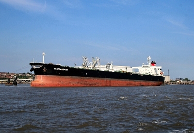 |
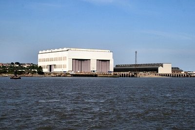
Oil Tanker at Tranmere Oil Terminal Tranmere Oil Terminal, near Birkenhead, was opened in 1960 to handle vessels of up to 65,000 tons. Crude oil is pumped from Tranmere through a 15 mile (24 km) pipeline to storage tanks at Stanlow Oil Refinery. Part of the terminal occupies the site of a former ferry service to Liverpool, with the extant pier considerably modified. |
|
| Tranmere in Lewis's Topographical Dictionary of England (1848) This place lies between the town of Birkenhead on the north, from which it is distant about a mile, and the village of Rock-Ferry on the south; it has the Mersey on the east, and is backed by commanding hills forming an agreeable slope to the river from the west. Its picturesque situation admirably adapts it for building, and much of the land has within the last few years been sold for the purpose at very high prices [...]. Tranmere, like Birkenhead, is becoming of considerable importance, and is now principally the residence of merchants and others whose business lies in Liverpool. A large tract called Clifton Park, at the north end of Holt Hill, has been laid out for building, and is already nearly covered with villas and mansions of the first class, having pleasant drives and lodge entrances; on another plot of ground, at the south end of the hill, called Dacre Park, many residences have also been built, and no doubt in a few years the whole site and the adjacent parts will be similarly occupied. Throughout the township, abundance of good stone of a light-red colour and very durable is to be found, and some of the quarries are now worked to considerable advantage: brick clay also is very abundant. [...] The river Mersey from Birkenhead to Rock-Ferry, called the Sloin or Sloyne, is very deep, and affords excellent anchorage for first-class vessels: the Lazzerets lie a little below. There is an ancient ferry; and docks are contemplated. It is said by merchants and shippers that the new docks ought to have been constructed in the bay of Tranmere instead of at Birkenhead, owing to the great depth of water in the Sloin, and to its being so completely backed by the hills, which would afford admirable shelter for the shipping. |
||
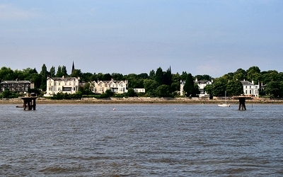 |
Rock Park Esplanade, Rock Ferry Rock Park is a private residential estate that was laid out on the left bank of the Mersey estuary in 1836-7 by surveyor Jonathan Bennison. Detached and semi-detached housing was constructed up to 1850. The leafy enclave has a serpentine drive and an esplanade on the waterfront. It was mainly intended as a summer resort; there were ferry connections to Liverpool, Rock Ferry at the northern end and New Ferry to the south, each with a hotel (the Royal Rock Hotel and the New Ferry Hotel, respectively). It was an exclusive location allowing for 'no trade or business other than the learned professions to be carried on'. American author Nathaniel Hawthorne lived here when serving as Americal consul in Liverpool. He reported a toll system that 'precludes all unnecessary passage of carriages' and talked of 'new and neat residences' each with an attendant barring the way to the 'ragged and ill-looking'. Sightseers not welcome, then. Mind you, since the New Ferry bypass (described in the Pevsner Guide as 'an unforgivable act of vandalism') was constructed it has become tricky for the uninitiated to locate without a map. Intrepid explorers will find the estate nicely preserved. |
|
| Rock Ferry in Lewis's Topographical Dictionary of England (1848) About twenty years ago, a large tract of land here was purchased, together with the right of ferry across the Mersey, by a gentleman of Liverpool, who much improved the ferry, built a large and excellent pier, formed roads, and encouraged the erection of buildings. A company was subsequently established, by whom the Hotel was enlarged to its present extent; new pleasure-grounds were added, and more commodious ferry-boats were employed. Several members of the company purchased lands on the margin of the river, and these, with others, were formed into a park, planted, and laid out in a picturesque manner. No part of the shores of the Mersey has since undergone a more rapid or pleasing transformation. The district comprises about 500 acres, of a stiff clay soil, and is chiefly laid out for the country residences of the Liverpool merchants, professional gentlemen, &c. The allotment called Rock Park contains a number of substantial mansions, and is embanked by an esplanade to which the river flows up at high water, and which forms a delightful promenade: to the west is Highfield Park, also consisting of detached houses; and on the south is a large plot of land laid out for villas. The river has a lake-like appearance at high water towards the southeast, at which point the views include Aigburth, Speke, Runcorn, Delamere Forest, Beeston Castle, &c.; while on the north-east is seen the town of Liverpool, with the entire range of docks and piers to the mouth of the Mersey. |
||