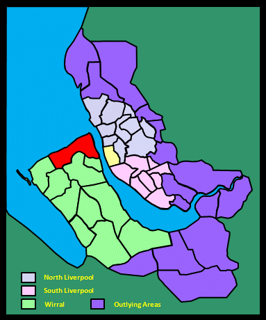
|
|
|||||||||
|
|
|||||||||
| Home Page: merseySights |
Home Page: allertonOak |
|||
 |
| CLICK A BOOTPRINT FOR A RELEVANT WALK - LINKS TO OTHER SITES AT THE BOTTOM OF THE PAGE |
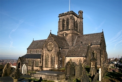 |
St.
Hilary's Church, Wallasey St. Hilary's is the parish church of Wallasey. A notice outside proclaims that there has been worship here for 1400 years and the present church is believed to be the sixth on the site. There was probably a timber Saxon church before the year 902, when the Vikings named the hamlet Kirkeby in Walea meaning 'the village with the church on the island of the Britons'. The reference to an island presumably refers to the time when this area was cut off by Wallasey Pool and marshland that reached across to the sea at Leasowe. Several stones have been found of a Norman structure, thought to date from 1162-1182, on the site. This was rebuilt and a tower added during the reigns of Edward I and Edward II. The next rebuilding was in the 16th century, when the tower was reconstructed in 1530. In 1757, the church was in ruins and was rebuilt. This fifth church burnt down in 1857, but the tower still stands alone in the churchyard. The present one was completed in 1859, using stone donated by a local quarry, in a style felt to be in keeping with the new wealth and status of the rapidly expanding Liverpool and Merseyside port and economy. It contains a lot of fine 19th and 20th century stained glass.There are only eight churches in Britain named after the French Bishop of Poitiers, St. Hilary. It is likely that these churches were founded by another French Bishop, St Germanus, who came from near Poitiers and who was invited as a missionary by the 5th century English church. |
|
| Wallasey in Lewis's
Topographical Dictionary of England (1848) This parish, situated in the north-west corner of the county, is a peninsula of triangular form, bounded on the west by the Irish Sea, on the north-east by the Mersey, and on the south-east by a branch of the Mersey, called Wallasey Pool or the new Birkenhead Float. Bordering on the sea are sand-hills, forming a natural barrier against its encroachments. Many handsome houses and marine villas have been erected on the banks of the Mersey, and the villages near the river are much frequented for bathing. An act was passed in 1845 for paving, lighting, and otherwise improving the parish, and for establishing a market. By the sea side is an ancient mansion denominated Mockbeggar Hall, or more properly, Leasowe Castle, formerly a seat of the Egertons. The building originally consisted only of an octagonal tower, with square turrets on the alternate faces; in 1818 great additions were made to it, and many alterations since, so that the castle is now of considerable extent. It is a decorative stone structure containing several handsome apartments, among which is one fitted up with the oak panelling that covered the walls of the celebrated Star Chamber at Westminster, and which was purchased on the demolition of the old Exchequer Buildings, in 1836. Between the village and the shore is the inclosure (formerly a common) named the Leasowe, where races, of very early origin, were held till 1760; here the unfortunate Duke of Monmouth ran his horse, in the reign of Charles II., won the plate, and presented it to the daughter of the mayor of Chester. [...] The general surface is flat, and there are some quarries of sandstone. [...] The church, rebuilt about 90 years since, except the tower, which bears date 1530, stands in the centre of the parish, on a hill composed of red-sandstone: it was enlarged in 1837. There were two other churches prior to the Dissolution, appropriated to Birkenhead Abbey, but no traces exist of them, though a path is still called the Kirkway. |
||
| Wallasey in The
Beauties of England and Wales, Vol II, Edward Wedlake
Brayley and John Britton (1809) Wallisea is a spacious but deserted mansion, standing near the village of the same name, at the northern corner of the Wirral Hundred. [...] Between one and two miles from Wallisea, a very noble hotel was erected, about ten years ago, by Sir John Thomas Stanley, Bart. of Alderley, for the accommodation of persons visiting the sea side. This is much frequented in the summer season by the resident families of Cheshire and its neighbourhood, who visit this spot for the purpose of bathing in Hyle Lake, which is bounded by the projecting land of the Wirral peninsula, and the coast of the small Isle of Hilbree, or Hillebyri. The Isle is about one mile in circuit, and though the soil is scarcely anything but sand, had formerly a cell of Benedictine monks, belonging to the abbey at Chester. [Hyle Lake] was named Wallase Lezer, a large fine spot, where races were run for many years; but those races are now run at Newmarket, though still called the Wallisea stakes. |
||
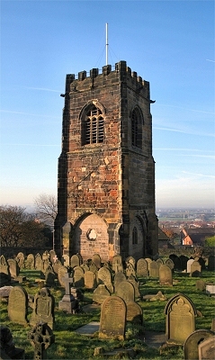 |
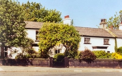
The
Old Tower, St. Hilary's Church, Wallasey This 1530 tower was left standing after a disastrous fire in 1857. |
|
| St. Hilary's fire in the Liverpool
Daily Post on the 2nd February 1857 The Parish Church of Wallasey, an ancient edifice, was utterly destroyed by fire yesterday forenoon. [...] It appears that yesterday morning, so early as 2 o'clock, an inhabitant of the village, on looking through his bedroom window, discovered smoke and flame issuing from the church, and immediately communicated the fact to the rector, the Rev P Haggit. The Rector and several of the parishioners proceeded at once to the spot, and found that the flames were breaking through the windows, and the fire presented an alarming aspect. A messenger was dispatched for the Birkenhead Fire Brigade [...]. In the meantime the flames spread rapidly, the persons present being unable to do anything towards arresting their progress. From every window the fire burst forth, and burnt with such brilliancy as to be visible from a distance of several miles. In a brief period the roof fell in, shortly afterwards the fire brigade from Birkenhead arrived at half past three, but even then any efforts they could make were inoperative from the want of a supply of water. [...]. The body of the church was completely gutted and presented nothing but a heap of smouldering ruins. [...] The organ created a few years ago, and which cost three hundred guineas, was totally consumed, also a handsome font, presented to the church by Mr Chambers. The church contained a set of six bells, which fell with a tremendous crash during the progress of the fire. Only two of the bells remain entire, the remainder being broken to pieces. The church underwent very extensive improvements a year or two ago, and a large sum of money was expended. A new roof was added, and the organ and the font previously alluded to were introduced at the same time. As to the origin of the fire there is little doubt. The fires connected with the flues for heating the building were lighted as usual about eight on Saturday evening, and it is supposed that some of the flues, becoming overheated, had ignited the flooring, and thus led to the fatal results which followed. [...]. The church was one of the oldest ecclesiastical edifices in the neighbourhood. The tower bears the date of 1530, although the church itself was rebuilt about 100 years ago. The ruins constitute an interesting sight, and during the whole of yesterday crowds went to view the desolation. |
||
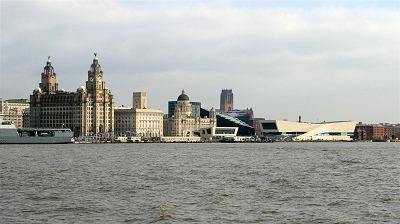 |
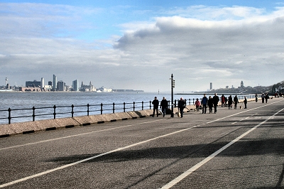
The
Liverpool Waterfront from Seacombe Seacome was Poulton-cum-Seacombe in earlier times, the places now separated. |
|
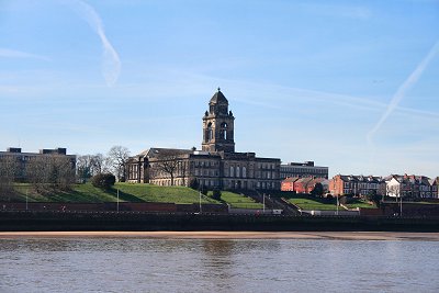 |
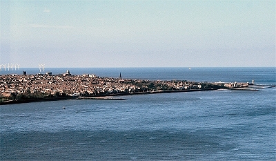
Wallasey
Town Hall The rather grand Wallasey Town Hall is a prominent landmark overlooking the river, which is its best viewpoint. It was completed in 1920. |
|
| Seacombe in Lewis's
Topographical Dictionary of England (1848) This township is bounded on the east by the river Mersey, on the north by Liscard, and on the south by Wallasey Pool; and comprises [..] mostly arable and pasture land, and chiefly of a clay soil. Being situated opposite to Liverpool (to which a steam-boat plies every half hour), there is a fine view of that town and its vicinity; while in another direction are seen the Cheshire hills and the Welsh mountains. The village is situated on Wallasey Pool, and overlooks Oxton hill, Birkenhead, &c.; it is remarkable for the salubrity of its air. Much land has been reclaimed in the township, by the Birkenhead Dock Commissioners. Here are very extensive works of various kinds. [...] At the eastern extremity of the township is the station of the ancient ferry, with a large hotel. The ferry [...] has a good supply of steam-boats; and the hotel is furnished with a bowling-green, a billiard-room, and every accommodation. The rapid tide occasioned by the inlet of Wallasey Pool, rendered the landing inconvenient until the erection of a stage, of a very uncommon construction, worked by means of a moveable steam-engine, upon a tramway. To the south of the ferry, a row of pleasant houses now faces the Mersey, and the shore is crested with elegant residences. [...] Poolton [Poulton] village, which lies a mile up Wallasey Pool, from its situation in a small cove bordered with flourishing trees, and the rural simplicity of its houses, forms a pleasing contrast to the activity and bustle prevailing at the ferry. [...] Magnetic sand [...] is to be seen along the coast from Seacombe Point to the Rock lighthouse, oozing from under the bed of clay, and streaking the shores with black: the magnetic sand is easily attracted by the magnet. |
||
 |
Egremont Quay | |
 |
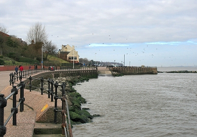
Egremont
Promenade Torquay? Not quite, but the view from the Egremont Ferry quay goes some way to explaining the popularity of excursions to this side of the Mersey for more than 100 years. There have been no ferry services here since 1941, but the ferry ride to Seacombe followed by the walk to New Brighton is still the essential day out for scousers. Note how clean the sand is. When I was a kid, the tide washed up unspeakable things around here. Thankfully things aren't always what they used to be! |
|
| Mother Redcap in Recollections
of Old Liverpool (1863), an
anonymous author recalling the mid-18th century Near Egremont, on the shore, there used to be a little low public house, known as Mother Redcap's, from the fact of the owner always wearing a red hood or cap. This public house is still standing. I have often been in it. [...] Mother Redcap was a great favourite with the sailor-men and had their entire confidence. She had hiding places for any number, and the men used, on returning from their voyages, to deposit with her their pay and prize money, until they wanted it. It was known, or at least, very commonly believed, that Mother Redcap had in her possession enormous (for her) sums of money, hidden or put away somewhere, but where that somewhere was, it was never known; for, at her death, very little property was found in her possession, although only a few days before she was taken ill and died, a rich prize was brought into Liverpool which yielded every sailor on board at least a thousand pounds. Mother Redcap's was swarming with sailors belonging to the privateer, directly after the vessel had come into port, and it was known that the old lady had received a good deal of the prize money on their account, yet none of it was ever discovered. It is a very remarkable circumstance that some few years ago, I think about ten or twelve, but I forget exactly when, a quantity of money in spade-ace guineas was found in a cavity by the shore, not far from Mother Redcap's. It has always been a firm belief with me that some day a rich harvest will be in store for somebody. |
||
 |
Mother Redcap's Memorial, Egremont | |
| Liscard in Lewis's
Topographical Dictionary of England (1848) Some years ago this township presented an almost barren waste, large heaps of sand lying in many parts, and there being only a village, with a few small hovels the abode of fishermen, and a range of low cottages used for a magazine. An extensive and rapid change has, however, been effected; several settlements have been made, and labour and enterprise have succeeded in fertilizing and enriching a district for which nature seemed to have done so little. The shore for a great distance is now studded with elegant houses, and even among the sand-hills many spots have been chosen for villas, which are the residences of opulent families from Liverpool. New Brighton, in the township, has sprung up since 1830. In that year the late James Atherton, Esq., conceived the design of founding a watering-place at the north-east angle of the township, and in furtherance of his plan purchased 180 acres of ground in that quarter, where the convex form of the coast, presenting one front to the Mersey and another to the open sea, appeared well adapted to the purposes of a marine village. Here streets fifteen yards in width, and nearly a mile in extent, now ascend from both shores, and intersect each other at right angles; the whole being laid out on a regular and symmetrical plan, with a pier having the requisite landing-stages, an hotel and other accommodation for visiters, hot and cold baths, &c., and, in short, every convenience for either permanent or temporary residence. The erection of buildings continues on every side, many of them being highly ornamental and elegant; and the village promises to be, at no distant day, one of the most fashionable watering-places in this part of the kingdom. The hamlet of Egremont is also in the township, and on the Mersey, nearly opposite to Liverpool, from which it is distant one mile and a half; it contains several handsome dwellings, hotels, and lodging-houses, and is likewise a favourite and genteel bathing-place. Near this hamlet is the magazine where all ships entering the port of Liverpool deposit their gunpowder, prior to admission into the docks. Steam-boats ply every half hour from New Brighton and Egremont to Liverpool. |
||
 |
Mariner's
Cottage, New Brighton The old part of New Brighton is charming and peaceful, though compact. There are several old properties such as these. |
|
| New Brighton in Lewis's
Topographical Dictionary of England (1848) A bathing-place [...]. It forms the north-east corner of the peninsula of Wirrall, being bounded by the river Mersey on the east, and on the north by the Irish Sea; and comprises 180 acres, of undulated surface, and hilly in some parts, the whole laid out in roads, and studded with mansions, many of them of much architectural beauty. The striking features of the locality have been taken advantage of in constructing a series of marine villas, which, rising one above another, have a most picturesque effect as seen from a distance. Spacious streets, fifteen yards wide, have been formed: several excellent hotels and boarding-houses have been built; and the accommodation which the place affords, the salubrity of its air, and the convenience of bathing, have made it the residence of eminent merchants, and the resort of visiters generally of the wealthy classes. The sandy beach is very smooth, dry, and firm; and the water on the shore, beautifully pellucid. From the higher grounds are extensive views of the Welsh mountains, the opposite port of Liverpool, and the shipping on the Mersey. A reservoir has been constructed for supplying the inhabitants with water, and on the shore is a spring of fine fresh water, which, though covered over by the tide, is perfectly pure when the sea retires. Upon the Black rock, where the Mersey enters the Irish Channel, is a very strong fort, mounting fifteen large guns, and approached from the main land by a drawbridge; and further off the shore is a small lighthouse, on the plan of the Eddystone, built of Anglesey marble at a cost of £34,500, defrayed by the corporation of Liverpool: it rises ninety feet, and is completely surrounded at high tides, like the fort, by the water. Steamers run to and from Liverpool every hour. A site and £500 have been offered for building a church, and plans are in progress for its erection. The masses of sandstone near the Black rock, called the Red and Yellow Noses, well merit the attention of the naturalist, being worn by the action of the sea into a variety of caverns of the most romantic forms; a tunnel has been cut through one of them from the beach, forming a private entrance up to Cliffe Villa. |
||
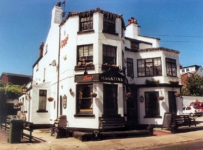 |
The
Magazine Pub, New Brighton A great little pub on Magazine Brow in the old part of New Brighton set just back from the river near Vale Park. You can sit in front and look out over the river - very pleasant. |
|
 |
The
Magazine, New Brighton The magazine, in the old part of New Brighton, was used for the storage of gunpowder. It was located well away from the nearest docks in case of explosion (presumably when this was a more rural area). The explosion of the gunpowder ship Lotty Sleigh on the River Mersey in 1864, which caused devastation over a three mile radius, showed what could happen given a chance. |
|
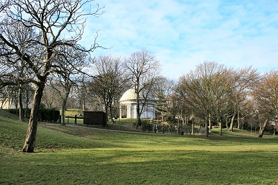 |
Vale Park, New Brighton | |
| New Brighton in Recollections
of Old Liverpool (1863), an
anonymous author recalling the mid-18th century There were no houses then anywhere about what is now called New Brighton. The country was sandy and barren, and the only trees that existed grew close to the mouth of the river near the shore. There was scarcely a house between the Rock and Wallasey. Wirral was a desperate region. The inhabitants were nearly all wreckers or smugglers - they ostensibly carried on the trade and calling of fishermen, farm labourers, and small farmers, but they were deeply saturated with the sin of covetousness, and many a fierce fire has been lighted on the Wirral shore on stormy nights to lure the good ship on the Burbo or Hoyle Banks, there to beat, and strain, and throb, until her timbers parted, and her planks were floating in confusion on the stormy waves. Fine times, then, for the Cheshire men. On stormy days and nights, crowds might have been seen hurrying to the shore with carts, barrows, horses, asses, and oxen even, which were made to draw timber, bales, boxes, or anything that the raging waters might have cast up. Many a half-drowned sailor has had a knock on the sconce whilst trying to obtain a footing, that has sent him reeling back into the seething water, and many a house has been suddenly replenished with eatables and drinkables, and furniture and garniture, where previously bare walls and wretched accommodation only were visible. Then for smuggling fine times the runners used to have in my young days. Scarcely a house in north Wirral that could not provide a guest with a good stiff glass of brandy or Hollands. The fishermen used to pretend to cast their nets to take the fish that then abounded on our coasts, but their fishing was of a far different sort. |
||
 |
Promenaders at New Brighton | |
 |
New Brighton from Liverpool's West Tower | |
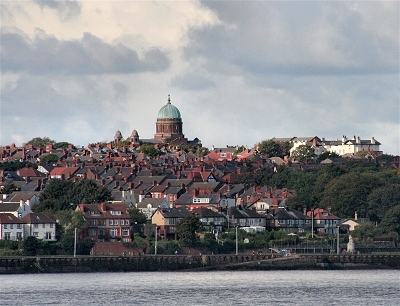 |
New
Brighton with the Church of St. Peter and St. Paul St. Peter and St. Paul's catholic church is a dominant landmark on the left bank of the Mersey Estuary. Its green dome has earned it the nickname The Dome of Home from returning sailors. It was opened in 1935 and its future is uncertain at the moment. |
|
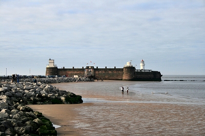 |
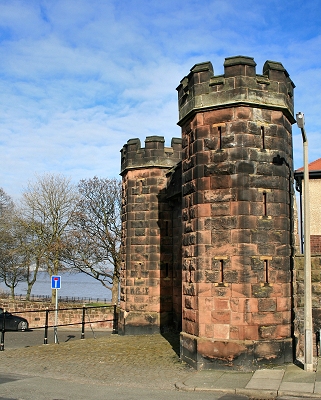
Fort
Perch Rock and the Lighthouse, New Brighton This Napoleonic defensive structure was finally completed in 1829, after Napoleon's death, and was nicknamed the Little Gibraltar of the Mersey. There were originally 18 guns and accomodation for 100 men. It was finally decommissioned and sold in 1954. After a rocky period (no pun intended), it is now restored and houses a museum. |
|
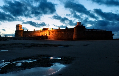 |
Fort
Perch Rock, New Brighton My thanks to Dave Steel for this photo. |
|
| Wallasey Caves in Recollections
of Old Liverpool (1863), an
anonymous author recalling the mid-18th century I have been up the tunnels or caves at the Red and White Noses [rocky outcrops on the Wallasey coast] many a time for great distances. I was once fishing for codling at the Perch, and with two young companions went up the caves for at least a mile, and could have gone further only we became frightened as our lights went out. It was thought these caves ran up to Chester Cathedral, but that was all stuff. I believe they were excavated by smugglers in part, and partly natural cavities of the earth. We knew little then of archaeology or geology, or any other "ology", or I might be able to tell a good deal about these caves, for I saw them more than once, but I now forget what their size and height was. The floor, I recollect, was very uneven and strewed about with big stones, while the roof was arched over in the red sand-stone. The encroachment of the sea upon the Wirral shore has been very gradual, but regular, for many years. Within the memory of man the sea has made an inroad of nearly, if not quite, a mile from its former high water mark. It was not until the erection of the Wallasey embankment that a stop was put to its ravages. |
||
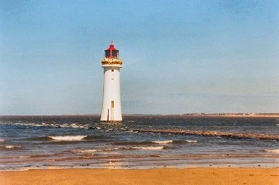 |
The
Rock Lighthouse, New Brighton The Rock Lighthouse, or Perch Rock Lighthouse, next to Fort Perch Rock, marks the extreme northern tip of the Wirral. The first structure here, erected in 1683, was a large wooden tripod or perch bholding a fire, hence the current name (formerly Black Rock). This was regularly destroyed by shipping and acquired a light in the early 19th century. Nevertheless it was demolished again in 1821 when a Mersey pilot boat collided with it during a storm. The present lighthouse is 93 ft (28 m) high and of very solid construction, costing £27,500 by the time it was completed in 1830. It had possibly the first revolving light in the country. It was decommissioned in 1973 when its role was superceded by the radar system at Crosby. |
|
| The entrance to the Mersey in Lewis's
Topographical Dictionary of England (1848) At the entrance of the river is the Black Rock lighthouse, erected on a point of rock on the western coast, which is covered at quarter flood, and above the surface of which the water at high spring tides rises 20 feet. This lighthouse was built at the expense of the corporation, from a design by the late Mr. John Foster, at an expense of £34,500, and was assigned to the Dock estate at a nominal rent: the structure is of limestone brought from Beaumaris, and was completed, and the light first exhibited, on the 1st of March, 1830; it is triangular, and presents successively two lights of a natural colour, and one of brilliant red, every minute. Floating lights, also, have been placed eleven miles seaward from the mouth of the river Mersey, by the committee for the management of the docks; and pilot-boats stationed there are constantly on the look-out. A new channel called the Victoria Channel, near Formby Point, was opened by dredging in 1835; and at Crosby Point is a lighthouse which, in conjunction with a light-vessel moored in the Crosby Channel, renders the port easy of access at all times of the tide either by day or night. [...] A telegraph is established, by means of which, communications have been interchanged between this town and Holyhead, distant 72 miles, in the space of a minute. |
||
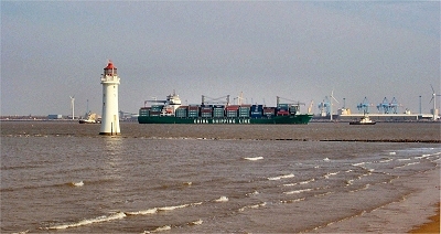 |
Entrance
to the Mersey at New Brighton A large container ship is being manoeuvered by tugs into the container port at Seaforth on the other side of the Mersey estuary. It is hard to imagine now, but there is strong reason to believe that the opening to the sea here did not exist until some time between the departure of the Romans (ca. 410 AD) and the Norman Conquest (1066). This would account for the complete obscurity of Liverpool until the 11th century. The Romans left no mention of a usable estuary here (or roads to it), although those of the Dee to the south and the Ribble to the north were of prime importance to them, as witnessed by the significant remains they left behind. The outlet of the river Mersey is presumed to have been through Wallasey Pool (Birkenhead Docks), Bidston Moss and perhaps along the line of the River Birket, reaching the sea at Leasowe Common near the lighthouse. There appears to have been a powerful earthquake in the fifth century, which may have been responsible for the new opening. There is a tradition that there was during the Dark Ages a bridge over the Mersey, then just a stream, between two large forested areas. There is much evidence of the latter on the local shores (particulary at Hightown, q.v.) and buried under the south-west Lancashire Mosses. |
|
 |
St.
James's Church, New Brighton St. James's Church is the work of George Gilbert Scott and was completed in 1856. |
|
 |
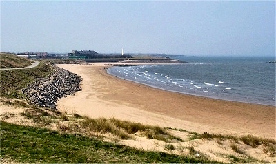
Beach
near New Brighton Local tradition has it that this part of the coast was where King Canute had his famous altercation with the waves. On the sea-front near Leasowe Castle, there was once a so-called Canute Chair with the inscription 'Sea come not hither nor wet the sole of my foot'. |
|
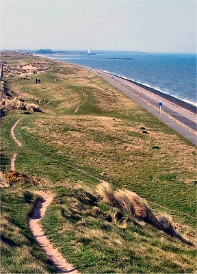 |
The
North Wirral Coast from New Brighton to Leasowe This area of the Wirral coast was once the haunt of a notorious community of wreckers. Following the wreck here at Christmas 1838 of the packet ship 'Pennsylvania' en route from Liverpool to New York during a hurricane-force storm, a Liverpool newspaper commented, 'We lament to find that these infamous wretches, the wreckers, have been at their fiendlike occupation, plundering what the elements have spared, instead of seeking to alleviate the calamities of their fellow creatures. The wreckers who infest the Cheshire coast were not long in rendering the catastrophe a source of emolument to themselves. The property of the passengers and crew where plundered by them to an alarming extent.' Another writer in 1863 noted, 'Wirral at that time [...] was a desperate region, the inhabitants were nearly all wreckers and smugglers, they ostensibly carried on the trade and calling of fishermen, farm labourers and small farmers, but they were deeply saturated with the sin of covetousness, and many a fierce fire has been lighted on the Wirral shore on stormy nights to lure the good ship on the Burbo or Hoyle banks, there to beat and strain and throb until her timbers parted and her planks were floating in confusion on the stormy waves. Fine times then for the Cheshire men. On stormy days and nights, crowds might have been seen hurrying to the shore with carts, barrows, horses, asses, or oxen even which were made to draw timber, bales, boxes or anything that the raging waters might have cast up. Many a half-drowned sailor has had a knock on the sconce, whilst trying to obtain a footing that has sent him reeling back into the seething water, and many a house had been suddenly replenished with eatables and drinkables and furniture and garniture where previously bare walls and wretched accommodation only were visible.' |
|
 |
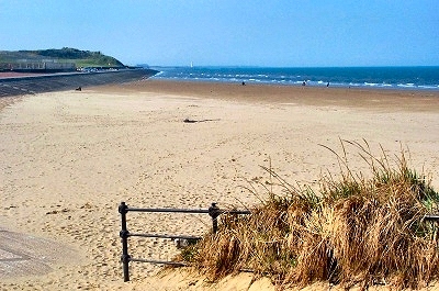
Leasowe
Shore This stretch of coast around Leasowe and Meols lies within the North Wirral Coastal Park, one of the country's top sites for wildlife and a Site of Special Scientific Interest. Wading birds, particularly Oystercatcher, Redshank, Dunlin, Sanderling, Turnstone, Lapwing, Bar-tailed Godwit and Curlew visit during the winter or migrate through in autumn and spring. Inland are rare plants and a very rare British sub-species of the Belted Beauty Moth, one of only two known sites in the world. The area was inhabited in stone-age times and remains of their habitations have been found on the beach. It remained important in Roman and Viking times. |
|
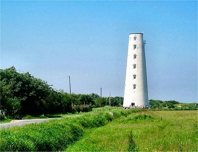 |
Leasowe
Lighthouse The first Leasowe Lighthouse (originally known as the Mockbeggar Light) was built in 1763 by the Liverpool Corporation Docks Committee. It was one of two, the other of which was a short distance off-shore and was washed away in a storm in 1769. Taking a sight on both lighthouses was intended to aid entry to the Mersey estuary. This function was restored by a new lighthouse on Bidston Hill in 1771. Two further lighthouses were constructed at Hoylake, then a major fishing port (the four Leading Lights). The present lighthouse was built in 1824 (the datestone is from the earlier one), the oldest brick built lighthouse in Britain, and was in operation until 1908. It is 101 ft (27 m) high and on 7 floors, accessed by a cast iron staircase and with accomodation inside. The light was housed unusually in a brick room with small rectangular windows. There used to be an adjoining keeper's cottage, but this was demolished when the lighthouse was decommisioned in 1908. The last keeper was a Mrs. Williams, who moved into a cottage when it ceased to function and kept the lighthouse as a popular teahouse in the summer. Wallasey Corporation acquired it in 1930. It was refurbished in 1989 by the Friends of Leasowe Lighthouse, who host guided tours, and houses a visitor centre on the ground floor. |
|
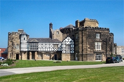 |
Leasowe
Castle The original castle (the 'New Hall'), consisting of just the octagonal tower, was built in 1593 by Ferdinando, the 5th Earl of Derby (of the Stanley family) and subsequently Mayor of Liverpool. It is often said to have been built as a viewing platform for the Wallasey horse races that took place on the nearby sands, but is more likely to have been simply a fortified home built in uncertain times. The Stanleys had apparently abandoned it within 100 years and it rapidly became a ruin. It became known as Mockbeggar Hall (a common epithet for ruined manorial halls) and the shore near here is still known Mockbeggar Wharf. It was restored and extended during the 19th century and, after further periods of dereliction, is now a hotel. |
|
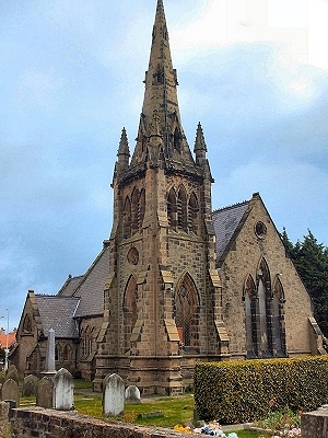 |
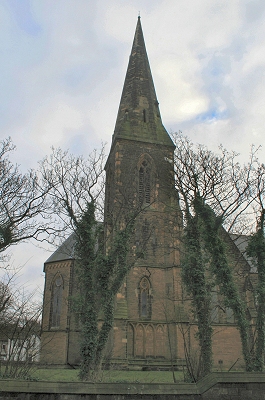
Christ
Church, Moreton Christ Church dates from 1863. |
|
| LINKS |
| Fort Perch Rock at merseyside.net |
| New Brighton at Scrapbook of Cheshire Antiquities |
| The Rock Lighthouse at merseyside.net |