Around Irby
allertonOak  
Last updated 29th May 2006
 Home Page: merseyWalks       Home Page: allertonOak      

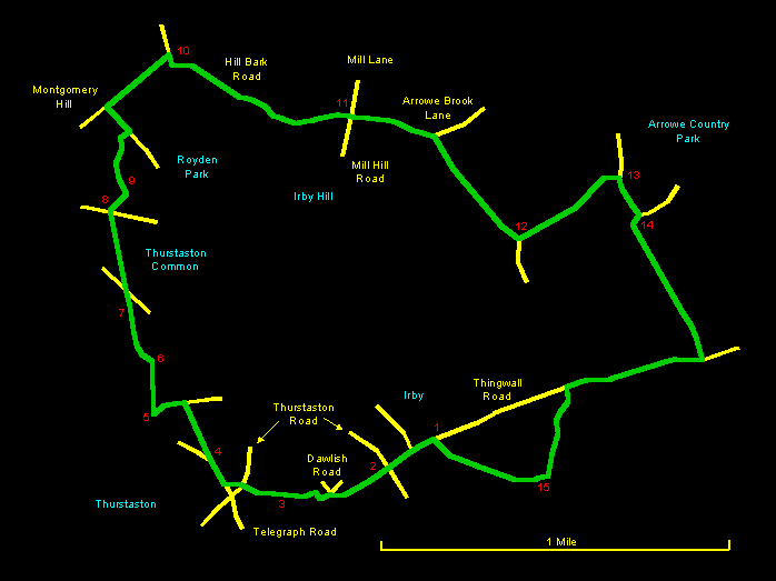
This is a fine and varied walk of about 5 miles (8 km) around the Irby area, taking in Thurstaston Hill and Common, Royden Park and Arrowe Park. The Thurstaston Area is superb countryside by any standards with some tremendous views. Royston Park is less wild but lovely countryside nonetheless and has the impressive, if somewhat tasteless, Hill Bark mansion. There are four pubs en route, one of them, the 18th century Irby Mill, meriting particular attention. The walk is over a variety of terrains with paths in mostly good condition and a couple of roads. Some parts are on smooth eroded sandstone and others can be very muddy, so this is one that's worth digging out the walking boots for.

The relevant Ordnance Survey 1:25000 Explorer map is No. 266. For further information on the locations visited, click on the images.

Detailed mapping and satellite photography for this walk courtesy of Bing Maps
Printer friendly page for this walk (no photos)
CLICK ON THE IMAGES FOR MORE INFORMATION

Start at the public car park [1] on Thingwall Road near Irby village centre. Walk to the Anchor Inn [2] in the village centre and take the footpath on its left. There is a fine view of the Welsh hills ahead. Exit the field via a stile at the right hand corner, which leads into Dawlish road. Take the track immediately to the left between the houses, which subsequently turns right behind the houses and then left and over a stile. Cross the next field diagonally past a pond [3] on the left and over another stile. In front of you is the spire of St. Bartholomew's Church with the Dee estuary and the Welsh hills in the background. The path comes out through some sandstone dwellings onto the end of Thurstaston Road.

Cross Thurstaston Road and go on to the busy Telegraph Road with the Cottage Loaf pub on the right. Soon after, take the track off to the right by a gate [4] (signposted Royden Park) to enter Thurstaston Common. You pass a school on the right and then turn sharp left before a gate up the hillside making for the trig point on Thurstaston Hill. A broad view over the Irish Sea emerges on your right, with Leasowe Lighthouse prominent. The summit marker [5] is a little further on with some of the best views in the Merseyside area - a great place to stop awhile.


Leave the summit with your back to the Dee estuary, looking somewhat to the left of Leasowe lighthouse. You will see a path heading over a broad area of sandstone steps. Make for this and then follow the path as it descends over small rocky outcrops (some of which will, as will others on this route, require care) and through heather. You will soon see the massive red lump of Thor's Stone [6] ahead through some trees. The direct path descends some slightly tricky rocks, which can be avoided using a diversion to the right. Thor's Stone is an impressive sandstone outcrop, the top of which can be reached by one of several easy scrambles, all of which, however, require considerable care because the rock is heavily eroded and very smooth.

Our path continues round to the left of the rock. The sandy trail winds through silver birches and over rocks and then drops down over some sandstone slabs to a prominent fir tree and a little stream [7]. Cross the stream and follow the path to a sandstone marker at a crossing of the ways. Go straight ahead, passing another waymarker and then going through trees to a gap in a wall [8]. Passing through the gap, you are in Royden Park and suddenly see Hill Bark mansion [9] up the hill ahead. It is undoubtedly impressive. Head up the slope to the right of the house and then take the path left just in front of it. The path bears round to the right through rhododendron bushes. Keep to the right until you come out onto the driveway. Turn left down the drive and then right onto Montgomery Hill. At the bottom of the hill is the Farmer's Arms [10].

Go right along Hill Bark Road, taking care as there are no footpaths here. You come to a roundabout where the old Irby Mill pub [11] is located. Go straight across onto Arrowe Brook Lane, not far along which is a clearly marked footpath on the right. Follow this to cross a bridge [12] over a brook and then turn immediately left alongside the brook. You cross a track via two gates and then pass through another gate and over a bridge [13] into Arrowe Park.

Take the path through the trees to the right, which eventually goes right over a brook [14] and then immediately left again. Follow this path to the end to emerge on Thingwall Road. Go right along this pleasant suburban road and look for the first gap in the houses on the left. Here there is footpath, signposted Pensby, that takes you through Harrock Wood. A delightful path traverses this narrow strip of woodland following a stream. You leave the wood and then turn right to cross the stream via steps and stepping stones [15]. Follow the right hand side of the next field and exit via a stile on the right just before the houses. Cross Thingwall Road diagonally to the right to reach where you started.