| Hoylake to West Kirby |
|
|||||||
| Hoylake to West Kirby |
|
|||||||
Home Page: merseyWalks  |
Home Page: allertonOak  |
|||
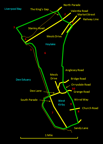
This fine walk of about 5½ miles (8½ km) skirts around the north-west tip of the Wirral and then takes an inland short-cut back to the start. Even though it is mostly along the coast, there are contrasts, as the section to the north-east of Hilbre Point is different in character from that to the south-east and the walk along the sea wall of the marine lake is different again. For refreshments, here are many decent restaurants in the centre of West Kirby and the route passes by one of the best pubs: the White Lion. The initial section of shore out to Red Rocks (which, by the way, is impassable at high tide, though the tide does not linger around here) has some thin smooth mud that is claggy and slippery. Suitable boots are therefore advisable. Please note that at exceptionally high tides or in stormy conditions it is not safe to walk the sea wall of the marine lake at West Kirby. Also, however temptingly close Hilbre Island may look from Red Rocks, the crossing here is not safe because of quicksand and deep cross-channels that fill rapidly when the tide turns. People who know what they are doing do make the trip but this site follows the official line and does not recommend it! The relevant Ordnance Survey 1:25000 Explorer map is No. 266. For further information on the locations visited, click on the images.
|
||||||
 |
| CLICK ON THE IMAGES FOR MORE INFORMATION |
 |
Start at Hoylake station [1] and head along Station Road to the roundabout on Meols Drive/Market Street. Cross over to the King's Gap and a little way along you may want to do a short detour to the right along Valentia Road to have a look at the old Hoylake Lighthouse [2] (now a private residence). Return to the King's Gap and head down to the shore at the end of the North Parade. In line with the shoreline, Little Hilbre Island is visible, while further to the right is Hilbre itself. |
 |
||
 |
To locate Red Rocks, make a bee-line for Hilbre Island (they are hard to see at this distance). You will see the low-lying sandstone outcrop [3] as you approach (muddy in places!). The rocks are a nice place to sit and take in the uninterrupted panorama of Liverpool Bay, the Welsh Hills, the Dee Estuary and the North Wirral and South Lancashire coasts. Head off towards Hilbre Point [4] with its fake lighthouse. |
 |
||
 |
Skirt to the right around the rocks at Hilbre Point, pass the end of Stanley Road with its slipway and follow the path inland for a short distance behind the first few houses. You soon pick up a boardwalk that crosses an interesting wetland area, the Red Rocks Nature Reserve [5]. |
 |
||
 |
Follow the boardwalk to the end (with the famous Royal Liverpool Golf Course [6] on your left), where there is a choice of paths, but the higher level one has the best views over the Dee Estuary and there is a good spot with a seat where you can rest for a while. Eventually you come out onto South Parade and head along here to the Marine Lake [7]. If conditions permit, head off along the sea wall to emerge at Sandy Lane. |
 |
||
 |
Heading up Sandy Lane, you will reach where the Wirral Way crosses. Turn left along the Wirral Way. If you like, turn off to the right at Church Road to have a look at the interesting and very old church of St. Bridget [8]. Return to the Wirral Way, which then passes through Ashton Park [9], where you can also have a wander if you like. The Wirral Way finally emerges on Grange Road, where, a short way up on the right is the enticing White Lion pub [10]. Head down Grange Road a short way and turn right into Orrysdale Road. Follow this as it crosses Bridge Road and becomes Anglesey Road. Where the latter turns to the right, you can pick up the path alongside the railway line back to Hoylake station. |
 |
||

