| Around Manley |  |
|||
| Around Manley | |
|||
This is a relaxed 4½ mile (7 km) stroll around a pleasant part of the Cheshire countryside that is less frequented by walkers. Refreshments are available just off the route about half way round at the excellent Goshawk pub in Mouldsworth. This is close to Mouldsworth station, which provides an alternative starting point for those without a car. Refreshments may also be available towards the end of the walk at Stonehouse Farm. The route is on well-defined paths, country lanes and over farm fields. The latter may be muddy so take the recent weather into account when deciding what to wear on your feet. The idea for this walk came from a Cheshire County Council leaflet, which I duly acknowledge. |
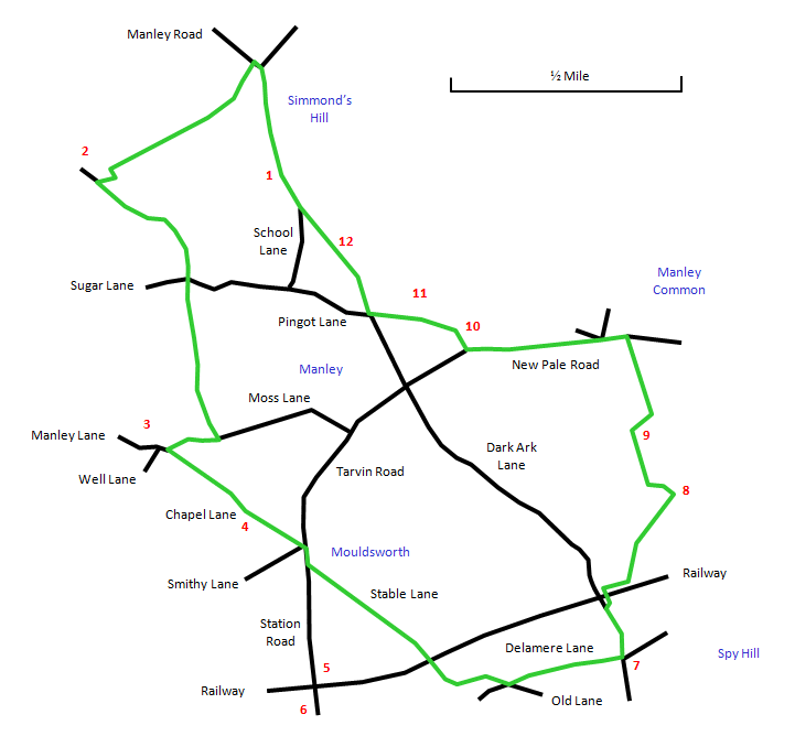 |
Park your car in the layby [1] on Manley Road near Simmond's Hill, about a mile and a half (2 km) to the south from the centre of Alvanley village. There is a fine view over the Cheshire Plain from here towards the Clwydian Hills, Stanlow Oil Refinery and the Mersey Estuary. Walk north along Manley Road, dropping downhill to a road junction. Cross a stile on the left here and follow the left-hand field boundary. You have to duck under two wires before entering a third field and heading downhill to a stile on the left near Manley Old Hall [2]. Cross this and follow the right-hand field boundary with a pretty view of the Hall. A further stile leads to a lane, where you turn left. |
Follow the lane to the junction with Sugar Lane and cross over to the stile opposite, signed Moss Lane. Here follow the right-hand field boundary past a triangular pond. Go over two more stiles, finally heading along a narrow path that emerges on Moss Lane. Go right along Moss Lane, passing some attractive cottages, to the junction with Chapel Lane. Just along from here is Manley Hall [3], once William Gladstone's family home. Turn left into Chapel Lane and go past Mouldsworth Methodist Chapel [4] to the junction with Tarvin Road. Less than half a mile (1 km) to the south down Tarvin Road are Mouldsworth Station [5] and the Goshawk pub [6]. |
Cross Tarvin Road and turn almost immediately into Stable Lane on the left. Where this turns into a path going straight ahead, follow it downhill under a railway bridge to cross Ashton Brook at the bottom. Follow the path until it emerges on Delamere Lane, where you turn left. At the next crossroads, where there is a picnic site [7], turn left into Dark Ark Lane. At this point you are on the Eddisbury Way. Just before the railway bridge on Dark Ark Lane, take the path to the right under the railway line and then follow the right-hand field boundary for a short distance to a way-marker post. Here branch off across the field diagonally to the left following a faint track. This passes through a gap in a hedge and crosses a second field, heading downhill to reach Ashton Brook again in an attractive woodland area. |
Cross the brook via a footbridge [8] and keep on ahead directly up the hill. At the top, follow the left-hand field boundary as it curves to the right and goes steeply uphill. At the top of the field is a nice quiet spot for a picnic [9] with a fine view south-east to Pale Heights. Cross the stile just here and follow the narrow path through the woodland, finally ascending up steps to a stile. Follow the left-hand field boundary up the hill to another stile on the left. Cross here and follow the broad farm track that eventually bends to the left and reaches a stile onto New Pale Road. |
The Eddisbury Way heads to the north along New Pale Road but we follow the road to the west. A short way along at Stonehouse Farm [10] there is a café with a pleasant outside seating area. Cross the stile on the right and follow the edge of the field by the farm and then cross a further stile on the left. Follow the narrow path past the grounds of the mansion called Ravelstone [11]. This leads to a kissing gate on Manley Road. Head right here, passing St. John's Church [12], and you are soon back at the starting point. |