| Tarvin and Hockenhull Platts |
|
|||||||
| Tarvin and Hockenhull Platts |
|
|||||||
Home Page: merseyWalks  |
Home Page: allertonOak  |
|||
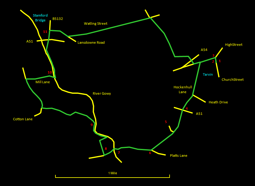
This is a walk of 5½ miles (8½ km) starting in charming and historic Tarvin, and taking in the ancient packhorse bridges of Hockenhull Platts, the broad grasslands of the Gowy Valley, Stamford Bridge and the route of Roman Watling Street. Although the route is largely level, there are ample opportunities for fine views over the beautiful Cheshire countryside. The Stamford Bridge pub, about ⅔ of the way round, makes an excellent stop for refreshments and a bite to eat, and there are more pubs in Tarvin. The way is a mixture of hard surfaces, grassy fields and paths. Parts can be quite muddy, so wear waterproof walking boots. Route finding is greatly aided where the tracks are not clear by Cheshire County Council's waymarkers. I am indebted to Tony Bowerman's book Walks in Mysterious Cheshire and Wirral, one of the walks in which forms the basis for this one. The relevant Ordnance Survey 1:25000 Explorer maps are Nos. 266 and 267. For further information on the locations visited, click on the images.
|
||||||
 |
| CLICK ON THE IMAGES FOR MORE INFORMATION |
 |
Start at St. Andrew's church [1] and try to make time either now or at the end of the walk to have a look around the churchyard and, if possible, the interior. Head along Church Street to the centre of the village, where the Red Lion [2] and George and Dragon [3] pubs are located, and turn left along High Street. |
  |
||
 |
Coming out of the centre of the village, turn left down Hockenhull Lane. Go past Heath Drive on the left and keep straight ahead onto a footpath at the bottom of the road where it turns to the right. You soon come to the A51 [4], which is busy and should be crossed with care onto the continuation of Hockenhull Lane opposite. This lane eventually curves round to the right towards Hockenhull Hall [5] (worth a quick look) and, where it does so, keep straight ahead on a straight track. You have a lovely view ahead towards the Welsh hills and to the left towards Beeston Castle and the Peckforton Hills. |
 |
||
 |
At the end of the track [6], ancient Platts Lane runs across at right angles. Turn right onto this, where it becomes a narrow path bordered by old hedgerows. |
 |
||
 |
You soon come suddenly upon the first of the old packhorse bridges [7] at Hockenhull Platts. There are three of these ancient structures in all: the second crosses the River Gowy, from the banks of which a good view is to be had, and the third is by a pretty pond backed by a striking line of poplar trees. This whole area is Hockenhull Platts Nature Reserve. Carry on along the path. It comes out onto a surfaced lane at the end of a plantation [8] on the right. Go right over a stile and follow the field boundary on your right, which is also the boundary of the nature reserve. Beyond the plantation are reed beds, at the end of which turn to the right to reach the bank of the River Gowy. Go left along the bank of the river to a gate with waymarkers [9] indicating a dividing of the ways. The one to the right appears to follow the river bank and may provide a short-cut to Stamford Mill, though I haven't verified this. We follow the one to the left, which takes a well-marked route along sheep-field boundaries and over stiles to reach Cotton Lane. |
 |
||
 |
Turn right along Cotton Lane, where there is a conundrum. The Ordnance Survey map shows a footpath going off across the fields to Stamford Mill, a route that Bowerman suggests taking. There is a metal gate here but no obvious entry and neither was there a visible path across the ploughed field when I was there. However, Google Earth shows a clear enough path through crops. To save running foul of the farmer, keep along Cotton Lane and turn right along Mill Lane to Stamford Mill [10]. There has been a slight but reasonable adjustment to the right of way at Stamford Mill that is well documented on signs provided, which indicate a path to the packhorse bridges coming in from the right, whether from Cotton Lane or along the Gowy I couldn't tell. At the mill buildings, go to the right across the field to a bridge over the Gowy and turn left along the riverbank for a good view of the mill buildings, the remains of the mill machinery and the mill pond. |
 |
||
 |
Keep along the riverbank, diverging to the right at the end to reach the busy A51. Cross with care and the picturesque Stamford Bridge pub [11] is right in front of you. Leave Stamford Bridge to the east along Lansdowne Road. At the end of the houses, take the footpath to the left. This keeps a fairly straight course along field boundaries and a ditch on the left following the course of the Roman Watling Street. |
 |
||
 |
Along here to the left there are nice views over towards Great Barrow and St. Bartholomew's church. Eventually you arrive at a crossing of the ways with a path going left over a footbridge. This is an ancient route connecting Great Barrow to Tarvin. Go right here, heading across the field. You kave to veer to the left at the end before reaching the A54. Cross carefully and go straight ahead along the short stretch of road to High Street. Turn left along High Street and you are soon back at your starting point. |
 |
||

