| Thurstaston and Caldy |
|
|||||||
| Thurstaston and Caldy |
|
|||||||
Home Page: merseyWalks  |
Home Page: allertonOak  |
|||
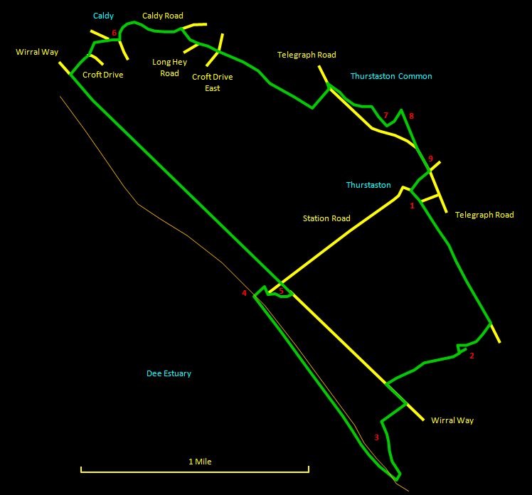
This is a superb walk of about 6 miles (9½ km) and an excellent sampler of what rural Wirral has to offer for those new to the area. It combines the tiny unspoiled hamlet of Thurstaston, a pretty little ravine, a stretch along the shore, the old heart of Caldy and the rocky top of Thurstaston Hill with fine countryside and views over the Dee estuary. There is an appropriately placed pub, the Cottage Loaf, just near the end. Most of the walk is on reasonable to good paths with a few roads, but the shore is muddy and stony in places and walking boots will greatly help to keep your feet comfortable. The relevant Ordnance Survey 1:25000 Explorer map is No. 266. For further information on the locations visited, click on the images.
|
||||||
 |
| CLICK ON THE IMAGES FOR MORE INFORMATION |
 |
Start at St. Bartholomew's Church [1] in Thurstaston and walk along the road beside the graveyard. This soon bends to the left, but keep straight ahead on a footpath signposted Heswall. This eventually passes a fir plantation, a series of stiles and a small pond. Immediately on the right is an initially paved footpath signposted Wirral Way. Follow this path, which is part of the Wirral Country Park Trail, through a band of woodland. A stream starts up on the right, which you soon cross over via a bridge. Here the stream drops in a waterfall into an unexpectedly deep and narrow little ravine [2]. This pretty area is known as the Dungeon. As the path descends, it moves away from the ravine to the right. About halfway down, take the path down the steps to the left to cross over the stream again via a bridge. Here you can walk back up into the ravine to see it from a different angle. Go right at the bridge past an old sandstone marker of some kind and follow the pleasant path through the trees to the Wirral Way. |
 |
||
 |
Go left along the Wirral Way and look out for the footpath on the right signed Heswall Fields Beach that leads into National Trust land [3]. This area is dotted wth little ponds. The path soon turns sharp left and then curves to the right down to the shore. The coast here has a distinctly different character from that further up the estuary because the water comes right up at high tide and there are sandstone cliffs). |
 |
||
 |
Our route is now north-west along the shore, which is muddy and stony in places. Keep away from the cliffs. They are heavily eroded and in places appear to be about to drop a couple of thousand tons of rock onto the shore. We arrive eventually at the old Shore Cottage [4], remarkably situated just above the water line. There is a pleasant stretch of sand here with a stream running down. Go up the steps to the right of the cottage, past the caravan park at the top and across the road to enter the pleasantly landscaped visitors' centre, where there are toilets and other facilities (there is also a caf? just over the bridge on Station Road). |
||
Rejoin the Wirral Way to the right of the main building [5] at the remains of the old Thurstaston station. Go left along the Wirral way, making sure you take the pedestrians' path on the left-hand side on leaving the station; this is much better for walkers as it is generally more elevated and varied than the cyclists' route. The way eventually passes under two bridges, with fine views over the Dee near Caldy. |
 |
At Caldy, you come out onto Croft Drive, which you follow to the right. Where the road curves to the right, take the pleasant wooded footpath more or less straight ahead up the hill between some seriously posh properties. This joins Caldy Road at the top where you go right towards the village green [6]. Sit by the village cross for a while and soak in the atmosphere. There is real old world charm here, with lovely old cottages dating from around 1700, some in sandstone and some in Cheshire Tudor style, and the quaint sandstone Church of the Resurrection and All Saints. |
 |
||
Follow the twists and turns of Caldy Road up the hill until you come to a point where there are foothpaths leading off both sides of the road. Take the narrow one on the right between houses, signposted Thurstaston. Go left at the end onto Long Hey Road and cross directly over at the bottom where it meets Croft Drive East. Ahead is a broad track signposted Thurstaston Hill. Where this makes a sharp turn to the left, go straight ahead over a stile along a narrower path. Pass through a gate and follow the field boundary on the left to reach the busy Telegraph Road. |
 |
||
 |
Go left along Telegraph Road and look immediately for a gap in the wall on the opposite side. Cross carefully and follow the path to the right on the other side of the wall, where you enter heathland characteristic of Thurstaston Common. The path eventually starts to diverge from the road and then there is a steep climb up Thurstaston Hill with a short rocky section at the top. Turn right along a well-worn track, which turns to rocks as you reach the trig point on the summit [7] at 300 ft (91 m). From here there are great views all around. Continue in the same direction and then take a path curving to the left, aiming for a large red-brick school building [8] with a red roof. Follow the track to the right along the side of the school to emerge back on Telegraph Road. Just along on the left is the no doubt welcome sight of the Cottage Loaf inn [9]. Cross the main road carefully and then turn right at the crossroads to arrive quickly back where you started. |
||

