| Waterloo to Hightown |  |
|||
| Waterloo to Hightown | |
|||
This walk from Waterloo to Hightown, following the Sefton Coastal Path, is about 4½ miles (7½ km) in length. It is a walk of contrasts, but the presence of the sea and reminders of man's varied attempts at taming it are here throughout. It begins in the pleasant northern suburb of Waterloo, where you see the massive sea defences at Crosby Marine Lake and Promenade, and finishes at the up-market, but strangely isolated, dormitory village of Hightown, by which time you will have passed along some of the most lonely coastline in the region. At the moment, there is the added bonus of experiencing Antony Gormley's shoreline installation Another Place in its entirety. The walk is worthwhile regardless of tides, but the atmosphere is quite different at high and low water. The route is not circular, but is conveniently located for using the frequent trains between Hightown and Waterloo. Either half of the walk can be undertaken by making use of the intermediate railway station at Hall Road. The way is on hard surfaces, good tracks and over sand dunes, so any sensible shoes will be fine. |
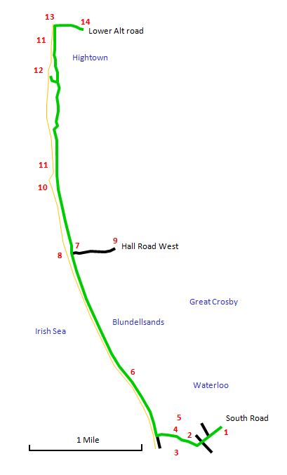 |
Start at Waterloo Station [1] and walk down to the bottom of South Road. Follow the road that cuts through the walled gardens [2]; there are elegant Victorian villas here on either side, painted in pastel shades. Take the path bearing to the right between Crosby Marine Lake [3] and the boating lake [4], noting the more ostentatious Sea Captains' Villas [5] over on the right. Emerge on the waterfront promenade, where there is a fine long stretch of golden sand that is usually almost empty. Just now you will also not fail to notice Antony Gormley's haunting shoreline installation Another Place: 100 lifesize cast iron figures gazing out to sea from here to the River Alt. |
Head along the promenade, first through dunes and then alongside the shore (at very high tides the waves can spray you here), until you reach the Coastguard Station [7] at Hall Road, noting the old landmark [8] on the shore. The broad sweep of the horizon here includes the Royal Liver Building, New Brighton and the north Wirral coast, the hills of north-east Wales, the mountains of Snowdonia and the Great Orme. The station [9] is a short stretch along Hall Road West if you want to do either of the shorter variants of this walk. |
Keeping ahead, the promenade immediately comes to an end to be replaced by a broad track. You can follow this, but a rougher track near the sea is more interesting. Here the sea defences continue in a more haphazard manner, utilizing housing rubble from bombsite clearances that has become smoothed by the tide into a more natural appearance. This is an area of wild flowers, especially dog roses, and blackberries. Ahead is a long breakwater [10] reaching out to sea. When you reach this, you will see its purpose: to divert the flow of the River Alt [11] away from the coast. |
Ahead is one of the most isolated stretches of coastline in the country, cut off by the railway line some way over to the east with no access roads and the River Alt to the west with, at low tide, endless stretches of sand out to the sea. Here you will rarely meet another person, but it is a paradise for wading birds. Eventually you enter a region of sand dunes, where several routes are possible; the Sefton Coastal Path has wooden waymarker posts with white painted tops. |
Through the dunes you reach a sailing club building on the outskirts of Hightown. A sign here points to the submerged forest [12], which is worth a quick detour. These are the blackened remains of 4000 year old trees. Back on the main route, you soon arrive alongside the Alt where sailing boats are moored. Opposite is the army's Altcar Rifle Range. Turn right at a boatyard and head up Lower Alt Road to reach Hightown station for the return journey. |