| Waterloo to Maghull |  |
|||
| Waterloo to Maghull | |
|||
This long walk of 10 miles (16 km) starts in Waterloo with a visit to the marine lake and shore and then takes a peaceful path through the northern suburbs of Liverpool by way of Rimrose Valley Country Park and the Leeds and Liverpool Canal to end up in Maghull. It can equally well be cycled, though there are a few short stretches of one-way system in Waterloo where cyclists will need to dismount. The way is flat and mainly on hard surfaces, though the canal towpath after Aldrins Lane can be a bit muddy in places. The route starts at Waterloo Station and finishes at Maghull Station, from where you can get a train back to Waterloo (change at Sandhills). There is pub, the Great Mogul, near the station for well-earned refreshments. Make sure your feet are comfortable and strike up a good pace! |
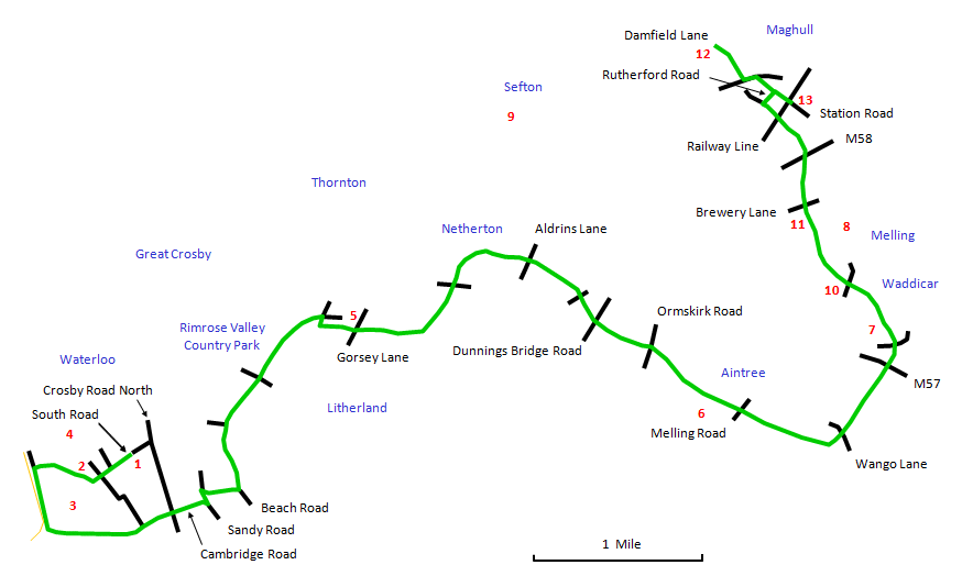 |
Turn left out of Waterloo Station [1] and walk down to the bottom of South Road, passing through the walled gardens [2] (there are elegant Victorian villas here on either side, painted in pastel shades). Take the path bearing to the right between Crosby Marine Lake [3] and the boating lake, noting the more ostentatious Sea Captains' Villas [4] over on the right. This rises through a gap in the sandhills to emerge on the waterfront promenade, where there is a fine long stretch of golden sand that is usually almost deserted. This is the start of Antony Gormley's haunting shoreline installation Another Place: 100 lifesize cast iron figures gazing out to sea from here to the River Alt. Turn left and follow the promenade to the end, where a path goes off left along the south side of the Marine Lake. Follow this to the end , where it comes out on Cambridge Road. |
Follow Cambridge Road across Crosby Road North. At the end it turns to the right into Sandy Road. Take a sharp left here up over the railway bridge. Immediately on the other side of the bridge, take a sharp right along a broad path signposted Cyclists Bootle. This crosses a brook by a wooden bridge and comes out at Beach Road, where you take the main path to the left, signposted Cyclists Netherton to enter the broad open spaces of Rimrose Valley Country Park. This landscape of grassland, coppices and ponds was created by landfill from the original valley. Proceed past a path on the left signposted Waterloo and go straight ahead at the subsequent crossing of ways following the sign Netherton by Canal Towpath. Eventually a similar sign points off along a narrower path to the right. Follow this to reach the canal near Cookson's Bridge [5]. |
Turn left along the canal towpath and follow it through Netherton to Aintree. This section of the walk is not terribly exciting, but it is pleasant enough and there are plenty of waterbirds for company. You eventually pass Aintree Racecourse [6] and, following a sharp bend in the canal, emerge into the countryside. You pass under the M57 motorway to reach Waddicar, from where [7] there is a nice view of Melling village on its little hill [8] with St. Thomas's church dominant. You can also see Sefton church (St. Helen's) [9] in the distance over on the left. Holmes Bridge [10], a swing bridge at a footpath to Melling, is a pleasant rural spot to sit and have a much needed rest. Here there is a rather over-enthusiastic signpost to Leeds! Continue on to Melling Stone Bridge, one of the original canal bridges. |
Past Melling Stone Bridge, you go under the M58 motorway and then under the railway bridge. Just at the end of a playing field on the left, there is a footbridge. Cross here and go along Rutherford Road. At the end is Station Road. If you have any energy remaining, it is worth going left here to have a look at St. Andrew's Church with its ancient chapel and then doubling back. This will add a further 1 mile (2 km) to the walk. Continue along Station Road, where you will find the Great Mogul pub and the Station. |