| Around West Kirby |  |
|||
| Around West Kirby | |
|||
This fine and varied walk is about 4½ miles (7½ km) long. Although it is located entirely within the residential areas of West Kirby and Caldy, some of the time you could be forgiven for thinking you were in the heart of the countryside. It passes through the elevated heaths and woodland of Grange and Caldy Hills (superb views), the picturesque centre of old Caldy and along the coast (literally at sea level sometimes). For refreshments, the route passes nearby one of West Kirby's best pubs: the White Lion. There are also many good restaurants in the centre of West Kirby. Where you are on paths, these are clearly defined, though the walking is mixed, with occasional muddy patches and rocky slabs. Walking boots are recommended, therefore. Please note that at exceptionally high tides or in stormy conditions it is not safe to walk the sea wall of the marine lake at West Kirby. My thanks to Anne Bryson for help planning this route and for providing local information for the corresponding merseySights items. |
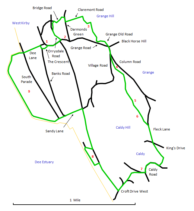 |
Start at West Kirby station [1] and turn right along Grange Road. Go past the leisure centre and turn right up Orrysdale Road. Just up from the corner here is the characterful White Lion pub [2] (save it until the end!). Take the path across the grass on the right and turn right up Bridge Road. Follow this round to the junction with Darmonds Green and then go right and immediately left up Claremont Road. At the end of the road is a path through the trees that goes up Grange Hill. Follow this and then bear right across more open heathland to reach the War Memorial [3] on the top of the hill. |
The view from the top is panoramic. Climb up to the left of the memorial and pick up the path to the right on the other side. You will see West Kirby Beacon ahead. The path comes out on Grange Old Road. Follow this round to the busy junction at Black Horse Hill. There is an attractive suburban view down Grange Road towards the sea with a rare (at these latitudes) Umbrella Pine on the right. |
Cross over Grange Road carefully and follow it to Village Road. Immediately after the junction a path goes off on the right through trees. You then pass through tall gorse bushes to reach West Kirby Beacon [4] on Caldy Hill. This is another good place to take in the view. |
Follow the path more or less parallel to the road, which passes an old sandstone gatepost and comes to a crossing of the ways at some sandstone slabs. Go straight ahead and the path rises over rocky slabs with a wall on the left (the site of an old artesian well) to come out at a viewing table [5]. This tells you what you can see in the panorama, but I have never been able to spot the Isle of Man so far. Head off with the estuary on your right and keep to the high ground. A little further on is a peaceful and attractive area of heathland [6] with a bench that is a good spot for a rest and a sandwich. |
Straight ahead, the path dips through trees and emerges through a gap in an old boundary wall onto Fleck Lane. Follow this down to the right, crossing over King's Drive, to emerge on Caldy Road, where you turn right and walk down into Caldy village [7]. |
Sit on the green and take in the old world charm of the village centre. Past the curve of the road by the church, a path takes you off down to the left through trees to meet up with Croft Drive West. Go down the road towards the estuary and then turn right onto the Wirral Way. A short way along, follow the signposted path on the left to Cubbins Green [8]. |
Cubbins Green is a pleasant elevated grassy area right by the waterfront. At the far end, take the path that angles sharply back to the right to rejoin the Wirral Way. Follow this to Sandy Lane and turn left to reach West Kirby Marine Lake [9]. If it is safe to do so, follow the sea wall of the lake where, at high tide, you almost seem to be walking on water (otherwise follow the South Parade). At the far end, go up Dee Lane and around The Crescent to reach your starting point at the station. You now have my permission to head up the road to the White Lion. |