| Willaston to Parkgate |
|
|||||||
| Willaston to Parkgate |
|
|||||||
Home Page: merseyWalks  |
Home Page: allertonOak  |
|||
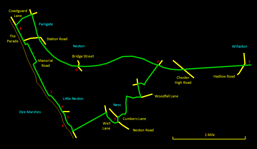
This fine walk from the pleasant village of Willaston, with its restored period railway station, to the historic sea port of Parkgate and back is about 8½ miles (13½ km) in length. The route includes a section of disused railway line, now the Wirral Way, and an atmospheric stretch along the edge of the Dee Marshes. Willaston, Little Neston and Parkgate are of significant historical interest. There are several pubs along the way to stop for refreshments, of particular note being the Harp at Little Neston. Although most of the walk is on very good paths or hard surfaces, the section along the marshes is intermittently very muddy and a bit rough, so walking boots are definitely a good idea. The relevant Ordnance Survey 1:25000 Explorer map is No. 266. For further information on the locations visited, click on the images.
|
||||||
 |
| CLICK ON THE IMAGES FOR MORE INFORMATION |
 |
Start at the Wirral Way car park [1] in Willaston, where you can walk directly into the old Hadlow Road Station. Walk along the platform and cross Hadlow Road to join the Wirral Way, which follows the route of the railway that used to run from Hooton to West Kirby. The way passes through attractive countryside and under three bridges, the last supporting the busy Chester High Road. |
 |
||
Eventually you come to a narrow wooden bridge [2] over a farm track. You need to go left onto this track and the best way is to cross the bridge, go down the path on the right and curve back under the bridge. Follow the track, which passes through a gate and becomes a narrower path up a gentle gradient. Follow this round to the right where a footpath is marked on the left. Another footpath soon crosses and you go left here. When you reach Woodfall Lane, turn right and follow it down to where Gorstons Lane joins from the right. On the left here, take the footpath past the children's playground. Go over a style and head straight across the next field on a less distinct trail. Near the far edge of the field, the way goes round to the right, past a house on the right, into Cumbers Lane. |
 |
At the end of Cumbers Lane, go left onto Neston Road. The Wheatsheaf pub [3] is along on the other side of the road. Go right at the pub into Well Lane, along which there are fine views over the Dee Marshes to the Welsh hills. About ª mile (400 m) along, take the broad track on the left, passing under a railway bridge, to reach the edge of the marshes. Go right and shortly you come to the old Denhall Quay [4]. |
 |
||
  |
This is a nice place to sit down and take in the view. Just along from here is the old Harp Inn [5], where you can enjoy either the unspoilt interior or the superb location outside on the marshes. |
 |
||
From the Harp, head off along the edge of the marshes. Not far on the right are the remains of the spoil heaps [6] from the old Wirral Colliery, now cosmetically covered in gorse and grass. A little further on over a small bridge is the substantial Neston Old Quay [7]. Pass along the top of this to where a vast ocean of reed beds opens out on the left. Where a house blocks the way, turn right and then left along Manorial Road. This turns into a path and then another road, at the end of which go left down a short narrow path, which comes out at the extreme end of the Parkgate quay. Go right past a slipway onto the main part of the waterfront called The Parade. |
 |
||
 |
Parkgate is full of interest. It is a unique and attractive place with many old whitewashed buildings and the original sandstone quay still intact. There are several pubs (the Red Lion [8] being perhaps the most characterful) and restaurants. However, the village does attract many visitors at weekends and public holidays. Walk along the front and turn right up Coastguard Lane by the chapel. Follow the road ahead until you reach the Wirral Way. Turn right onto the Wirral Way and follow it for some way until you reach a red-painted bridge [9] in Neston. There is a short hiatus in the path here, but keep on straight ahead under the railway bridge and up the suburban road that follows alongside a park on the left. At the top of the road, the Wirral Way starts up again. |
 |
||
You are now rewarded for the rather dull stretch just past by the most interesting section of the Wirral Way, where it passes through a deep narrow cutting in the sandstone for quite a distance. On emerging from this you soon reach the point where you left the Wirral Way earlier, so retrace your steps to the starting point. The old station is a nice place to sit for a well-deserved rest. |
 |
||

