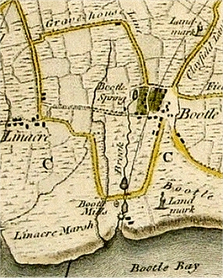
North Liverpool
Lost Rivers of Liverpool @ allertonOak  
 
Lost Rivers of Liverpool home page
allertonOak home page
Beacon 
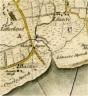
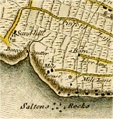
Gutter on the Yates and Perry Map of 1768 ...
Beacon Gutter
Beacon Gutter once marked the boundary of the Borough of Liverpool and Kirkdale (the latter was incorporated in 1835). It entered the River Mersey at a substantial inlet between Boundary Street and Sandhills Lane and there is still a kink in the Dock Road that marks the spot.
To the north was the village of Sandhills, once a pleasant area with a house also called Beacon Gutter. This was the retirement home of one Ellen Weeton in 1807. 'A fine elegant sounding name, is it not?', she wrote. 'Though only two miles from Liverpool [... there are] few people passing or coming in.'
The stream presumably took its name from Everton Beacon, a fire beacon that may have dated back to the 13th century. It was gutted by fire in 1782 and finally blew down in a storm in 1803. Even so, the Yates and Perry map shows only a rather short stream rising west of Pinfold Lane (later Vauxhall Road). Even this seems to have disappeared by the time of Sherriff's map in 1823.
In 1838, excavation of the gutter to build a sewer unearthed the remains of an ancient oak forest. This was thought to have stretched across the Mersey estuary as far as Leasowe to the west and Formby to the north, and to have survived possibly as late as the post-Roman period.
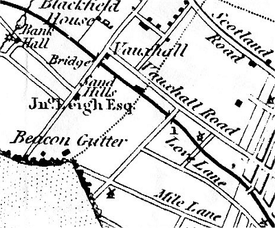
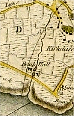
... and on Sherriff's Map of 1823
The Bank Hall Brook on the Yates and Perry Map ...
The Brook at Bank Hall
Just to the north of Beacon Gutter was a longer stream that probably had its source near the present lake in Stanley Park, and flowed down past the old Kirkdale Prison to Bank Hall Lane. Bank Hall itself stood near the junction of Bank Hall Lane and Juniper Street, and the brook flowed just to the north. On the opposite side was Kirkdale Marsh.
Bank Hall was the seat of the Moore family, the principal landowners in Liverpool, from the 15th century, when they moved from the Old Hall in Liverpool. There were two dams with ponds and a mill by the hall, which was demolished around the 1880s to build the Bankhall Distillery. There was no trace of the brook by this time as there had been extensive building of terraced housing further inland. It had originally flowed on to join the Mersey between the present Canada and Huskisson Docks.
Bank Hall in 1754 showing the brook and dam
... and on Sherriff's Map
The Mill Stream and Bootle Spring on the Yates and Perry Map ...
The Mill Stream and Bootle Spring
Bootle grew from Anglo-Saxon times around the important Bootle Spring located near what became the junction of Well Lane and Waterworks Street. The little brook known as the Mill Stream that flowed out of the spring was dammed twice near to its outlet at the present Alexandra Dock, the lower one powering a watermill. There was a windmill here as well and the area was known as Bootle Mills. The dunes and sandy coast around the outlet into the Mersey provided a popular bathing resort for the well-to-do in the early 1800s.
The potential to use Bootle Spring as a water supply for Liverpool was noted as early as c.1700. The story is taken up by Edward Baines in his History of the County Palatine and Duchy of Lancaster, Vol. 4 (1836):
  At Bootle-cum-Linacre are the works for supplying the town of Liverpool with water, from a spring which formerly discharged itself into the sea at Bootle Bay, after turning a mill within about half a mile from its source. [... an] act was obtained in 1799 [...] and water has since been brought from Bootle to Liverpool.
The arrival of the waterworks marked the end of the Mill Stream, which soon dried up and was built over.
Just to the north of the Mill Stream, an unnamed and substantially parallel brook had its source somewhat to the east of Derby Park and flowed towards where Bootle New Strand Station now stands to emerge into the Mersey near the north end of Alexandra Dock, an area once known as Linacre Marsh. Sherriff's map shows this sharing its outlet into the Mersey with the Mill Stream.
... and on Sherriff's Map
Tue Brook
Tue Brook (Tubrucke in the 16th century and later Tew Brook) had its source about half way along Green Lane in the district now known as Tuebrook. It made its way north towards the lake in Larkhill Gardens, Clubmoor, and then toward the recreation ground on Townsend Lane. It then followed a route that is still relatively undeveloped along the west side of Kelly Drive and the northern edge of Walton Hall Park to the lake there, and then north to the recreation ground near Rice Lane Station and across to the railway bridge on Long Lane.
Here in Fazakerley it makes its first present day appearance. Further upstream the remains of the brook are all culverted, though it is still believed to feed the pond in Larkhill Gardens. Flowing on to the east (here currently renamed Fazakerley Brook), it joins the River Alt at the very edge of the conurbation. This in turn flows into the Irish Sea at Hightown.
Tue Brook on the Yates and Perry Map ...
... and on Sherriff's Map
Rimrose Brook on the Yates and Perry Map ...
Rimrose Brook
Rimrose Brook has nowadays only an intermittent presence. It's original source was in the open ground north of Warbreck Park in Aintree from where it took a straight line north-west towards Bootle Golf Course, where it makes its current first appearance by Dunnings Bridge Road. It continues this line towards Netherton and then turns westerly at the Leeds and Liverpool Canal to reach its northernmost point just south of Edge Farm. From here it winds south-west through Rimrose Valley Country Park (originally a genuine valley but levelled by landfill over a long period), where it gradually gives up the ghost and eventually enters a culvert.
A new sewer was opened in 1949 when the original works, draining 700 acres (280 ha) of Bootle, Litherland and Seaforth, flooded regularly at times of high rainfall or tides, damaging homes and leaving an aftermath of smells and filth.
Originally the brook continued to just west of Seaforth and Litherland Station before flowing into the Mersey at a substantial tidal inlet where the southern end of the Seaforth Container Port now stands. It used to form the boundary between Crosby and Linacre Marshes and there was a bridge over the inlet at the junction of Crosby Road (an area of grand Victorian coastal mansions at the end of the 19th century) and Rimrose Road (with the Rimrose Hotel).
The early maps show a tributary of Rimrose Brook heading off towards Linacre village and crossing Linacre Lane (now Linacre Road).
... and on Sherriff's Map
 
Acknowledgements and Further Reading
For all you could want to know on the Rimrose Brook sewerage system, and then some, see Litherland Digital: Rimrose Brook Main Drainage Scheme. The engraving of Bank Hall is by W.G.Herdman, published in Pictorial Relics of Ancient Liverpool, 1843.
This is a non-commercial website that is intended entirely for research and educational purposes. If I have unintentionally breached copyright with any images, I hope that the copyright owner will tolerate my usage in the present context, otherwise I will remove the material. Modern colour photographs are by the author.