Geology and the First Inhabitants
A History of Allerton and Mossley Hill @ allertonOak  
 
A History of Allerton and Mossley Hill home page
allertonOak home page
300,000,000 to 10,000 Years Ago
Wherever you stand in Allerton or Mossley Hill you are not far above sandstone bedrock. It is visible in one or two places and there has been quarrying in the past, but you are more likely to notice where it has been used as a construction material for a variety of buildings and, especially, for the ancient field boundary walls, many of which have been preserved in one form or another.
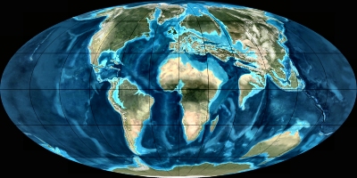
This is where, in the distant past, the story begins, for you stand on what was once an arid desert located near to the equator. By the start of the Permian period (300 - 250 million years ago), what is now England was evolving from a tropical landscape of luxuriant plant life with a vast complex of river deltas to an inland desert of the supercontinent known as Pangea. Sand had been formed by the action of wind, rain and rivers over a long period.
During the Triassic period (250 - 200 million years ago), England occupied a position similar to that of the Sahara Desert today. Internal lakes dried up forming salt deposits and sandstone was formed by the pressure of overlying deposits and cementation of the sand grains caused by the separation of some of the mineral content. The oxidation of iron-rich minerals gave the sandstone its characteristic red colour. In the early part of this period a large and turbulent river transported pebbles (mainly quarzite) from parts of France and deposited them widely over England. These became embedded in the emerging sandstone to form what are known as Bunter Pebble Beds. This is the kind of rock that underlies Allerton and Mossley Hill in the present day.
Folding of the Earth's crust due to continental drift continued over the Jurassic (200 - 145 million years ago) and Cretacious (145 - 66 million years ago) periods. The continental land masses gradually evolved until, by the Paleogene period (66 - 23 million years ago), they were recognisably like those of today. Piled on top of the rock in Allerton and Mossley Hill these days is an assortment of clay, pebbles, peat, sand and gravels formed and transported during the last Ice Age 110,000 to 12,000 years ago. After the Ice Age, the surface was further modifed by decaying vegetation and the action of wind and water (erosion and flooding).
The Permian, Triassic and Paleogene Periods
Fossilised mesolithic footprint at Formby shore
Petrified forest at Hightown
Mesolithic Times
During the Mesolithic period (8,000 - 4,500 years ago BC), the area occupied by the present outflow of the River Mersey into the Irish Sea was a land of fens and mudflats stretching about 8 miles (13 km) further out than at present. Evidence of early inhabitants (about 7000 years ago) has recently been discovered in the intertidal area of the Sefton Coast in the form of semi-fossilised human and animal footprints that have been exposed by erosion. The animals represented include wild boar, sheep, horses, deer and aurochs, the latter a precursor of modern cattle that stood six feet (2 m) high at the shoulder. These people were hunter gatherers, a nomadic existence that has left little in the way of remains. They are the earliest that we know of and inhabited much of the Merseyside area.
The outlet of the river Mersey at this time is thought to have been through Wallasey Pool, Bidston Moss and along the line of the River Birket, reaching the sea at Leasowe Common. Evidence of a forested area across the present Mersey outflow is most obvious near Hightown. Between the estuary of the River Alt and the sand dunes lies a considerable area of the blackened remains of 4,000 year old pine, birch, willow and oak trees, exposed at low tide. These have been preserved in peat and largely flattened to ground level. Similar remains have reportedly been found also on the opposite of the estuary at Leasowe and buried under the south-west Lancashire Mosses.
Neolithic Times
To its Neolithic inhabitants (4,500 - 2,500 BC), Allerton was an area of well-drained soils on top of sandstone and so relatively easy to clear of woodland. The lower lying land nearby was dense woodland, boulder clay, sandy areas and peat bogs. This would have made Allerton attractive to a people who had become farmers and tended to settle in one place. They left remains in Allerton itself in the shape of the Calderstones, the Robin Hood Stone and others now lost.
 
Acknowledgements and Further Reading
For a readable and entertaining survey of local geology, see Cheshire Geology at CheshireTrove. See also Beyond the Formby Footprints at www.nationaltrust.org.uk and The Calderstones at Mike Royden's Local History Pages. The geological maps are freely licensed images courtesy of Wikimedia Commons. The Formby footprint is courtesy of the National Trust.
This is a non-commercial website that is intended entirely for research and educational purposes. If I have unintentionally breached copyright with any images, I hope that the copyright owner will tolerate my usage in the present context, otherwise I will remove the material. Modern colour photographs are by the author.