| Introduction |
| This site
presents a history of Allerton and Mossley Hill,
two suburban areas of south Liverpool (the area I
am concerned with is defined precisely below). At
the time when recorded history began, this was a
farming and hunting region with nothing in the
way of significant population centres. However,
the area was populated at least as far back as
Neolithic times, as witnessed by the standing
stones that still survive, and the ground is
underpinned by rock that has its origins in the
desert landscapes of the Triassic Period. |
| Romans,
Anglo-Saxons and Vikings were in the area, but
for the 700 years following the Norman Conquest
the land was in the hands of a small number of
nobles and monastic institutions. Wealthy
citizens, many associated with shipping in one
form or another, then started to buy up the land
and build their mansions. The area was seen as
desirable because of its attractive countryside
and, especially as the Industrial Revolution
progressed, the purity of its air. |
| The arrival of
the wealthy merchant classes gathered pace in the
second half of the 19th century. Although many of
their houses were demolished in the 20th century,
a considerable number remain, though with
alternative usage. These men were often
philanthropists, who provided financial support
for the building of fine churches in the area and
many projects throughout Liverpool. |
| As incomes contracted
and costs rose in the early 20th century, much of
the land was sold to Liverpool Corporation for
public parkland. This remains one of the most
attractive aspects of the area today.
Suburbanisation began around 1900, but was
especially active in the 1920s and 1930s, and
again in the 1950s and 1960s. There was limited
scope for further development after that because
the extensive green spaces were protected from
development. The area retains many attractions
for the present inhabitants and visitors. |
| The
Area Covered |
| For my own
convenience and interests as much as anything
else, I admit now (to avoid any subsequent border
disputes!) that I have taken a slightly generous
interpretation of the area implied by my title.
Broadly speaking this is the ancient township of
Allerton plus those parts of the Liverpool 18 Postcode
Area not
included in it. I've regularised the rather
convoluted boundaries of the latter, so the area
is a little larger in fact. Mossley Hill is a
parish within the ancient township of Wavertree.
Proceeding clockwise from Wavertree, the other
neighbouring townships, several of which are
slightly encroached upon here, are Childwall,
Gateacre (originally Little Woolton), Woolton
(originally Much Woolton), Speke, Garston
(including Aigburth) and Toxteth. |
| The
north-western tip is the junction of Smithdown
Road and Ullet Road. Proceeding clockwise the
boundary follows Smithdown Road, Allerton Road,
Queens Drive and Woolton Road as far as the Black
Wood. It then takes a straight line to the
dog-leg in Vale Road, which it follows,
continuing along Hillfoot Road, the national
railway line to West Allerton Station, Booker
Avenue and Holmefield Road as far as South Sudley
Road. It then takes a direct line to North Sudley
Road, which it follows, continuing along Elmswood
Road and Aigburth Vale as far as Queens Drive,
from where it goes straight to the starting
point. |
| The northern
end of the boundary between Mossley Hill and
Allerton I have taken as the junction of Woolton
Road and Green Lane. It follows Green Lane,
Allerton Road, Rose Lane, Pitville Avenue and
Pitville Close, from where it takes a straight
line to the junction of Brodie Avenue and Cooper
Avenue, following the latter to Holmefield Road. |
| Info |
| This site is
the work of Laurence Scales and is part of allertonOak. |
| The site is
entirely non-commercial and is intended for
educational purposes. |
| The site is
best viewed at a minimum of 1024x768 pixels
resolution. The page layout will be optimal with
your browser at about 1200 pixels wide. |
| The modern
colour photographs on this site are by the author
except where specified; you may copy these for
non-commercial purposes only, but please place an
acknowledgement to www.allertonoak.net at their point of use. |
|
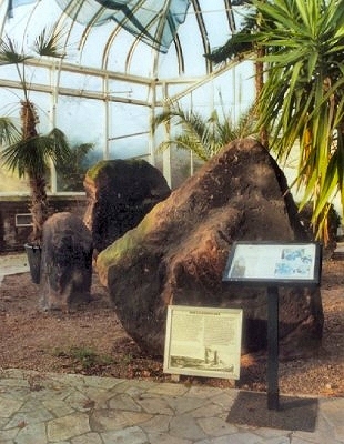 |
| The
Calderstones |
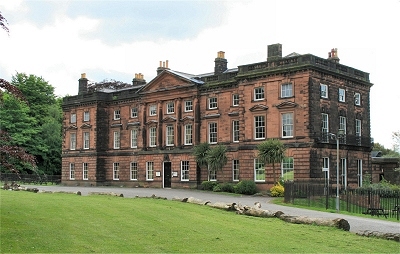 |
| Allerton
Hall |
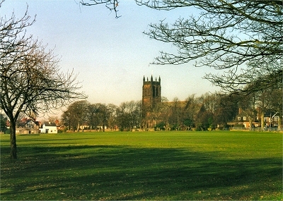 |
| All
Hallows Church |
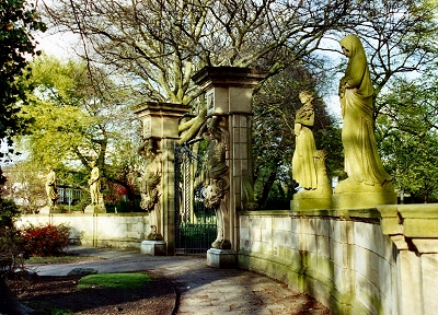 |
| The
Four Seasons |
|