| The South Liverpool Green Wedge |
|
|||||||
| The South Liverpool Green Wedge |
|
|||||||
| allertonOak - home page | |
| merseyWalks - home page | |
| Merseysiders who have not visited this area of Allerton and Woolton are missing a treat. This walk is about 3 miles (5 km) in length and, although entirely within the city boundary, makes no use of roads. If you're looking for peace and quiet, try and do it on a sunny weekday morning - you will have it almost to yourself and you can get a spot of lunch in Woolton Village at the end. There is plenty of history here and there to add interest. The route is almost entirely on good quality paths, either hard surfaced or firm ground. Short stretches may be muddy but walking boots are not essential. The main walk is not a circular route and bus services are available in Woolton Village if required. Alternatively a walk of a little over 2 miles (3 km) back to the start, largely following pleasant suburban roads, is suggested at the end (with some significant places of interest to Beatles fans thrown in). The relevant Ordnance Survey 1:25000 Explorer map is No. 275. | |
| Detailed maps and satellite imagery | |
| Mobile and printer friendly page | |
 |
 |
Start at the imposing Four Seasons entrance [1] to Calderstones Park on Harthill Road. The Four Seasons are statues of allegorical figures of Spring, Summer, Autumn and Winter. They were originally located on the roof of Brown's Buildings, an office block next to the Town Hall. The building was demolished in 1926 and the statues were relocated here in 1928. This part of the park was originally the estate of Hart Hill, built in about 1840 for the shipping magnate John Bibby. The house was demolished in the early 1930s but the two lodges remain. Go along the Jubilee Drive, commemorating the Silver Jubilee of George V and Queen Mary in 1935, when trees were planted along its length. You will reach a glasshouse on the right housing the neolithic Calderstones [2]. These are the remains of a burial chamber, perhaps 5,000 years old, originally located near the park entrance at the bottom of Druids Cross Road. There are six sandstone monoliths displaying a variety of original markings - spirals, concentric circles, arcs, cup marks and footprints - and others that may be graffiti from the last 200-500 years. Turn right and go past the orangery [3]. At the end of the path, go left and then right through a gap in a wall. |
 |
||
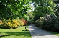 |
Here you reach the Rhododendron Walk [4]. In springtime this is a blaze of colour and in May you will also experience the heavy exotic scent of the azalea bushes. Our walk turns left here, but you can go along to the right and then retrace your steps. At the end of the Rhododendron walk are some elaborate wrought iron gates. These originally stood at Bidston Court, Birkenhead, which was demolished in 1930 and the gates donated in 1974. Straight ahead you pass the Summer Border, in high season a spectacular display of large flowering plants. |
 |
||
 |
At the end of the Summer Border on the left is the entrance to some beautiful formal gardens [5], well worth a short detour. The Flower Garden is an open plan walled garden with themed planting. The English Garden is a walled garden with trellises covered in climbing plants, seating areas, secluded paths and a lily pond. The Japanese Garden is a haven of peace and tranquility, sheltered from the wind and, if the pumps are working, pervaded by the sound of trickling water. |
 |
 |
 |
In front of you is the Georgian mansion house called Calderstone [6], built by lead shot manufacturer Joseph Need Walker in 1828. The house and estate were acquired by Charles McIver in 1875. He was a Liverpool shipping magnate, who had joined Samuel Cunard in establishing the British and North American Royal Steam Packet Company, later known as the Cunard Line. The house and estate were sold to Liverpool Corporation in 1902 and the park was opened to the public in 1905. A guided tour of the house is available. Adjoining it is a nice little café with seating outside and toilets behind. Take the main path that goes to the left of the mansion and then turn right opposite the old coach house. |
 |
 |
The path bends to the left and goes past some horses' graves that date from Joseph Need Walker's time. It then curves right and passes the ancient Allerton Oak [7]. Although a sign underneath claims that the tree is 1,000 years old, 500-600 years seems more likely; it has certainly been a famous landmark for centuries. 100 years ago it was a much more substantial tree but the strain of the branches eventually caused the trunk to split; many had to be removed, while the remainder needed propping up. At the end of the path is a rockery [8]. Take the path to the right here, where you can see to advantage many magnificent fir trees planted by Charles McIver. |
 |
 |
 |
At the end of the rockery go left along the edge of the central field. As the lake [9] comes into view, turn right onto a path leading down to it. This was originally a boating lake, opened in 1933, by which time Calderstones was being hailed as Liverpool's most beautiful park. Turn left at the lake to follow the line of the railings. At the end of the lake, to the left of the path, is the Bog Garden [10], originally a natural pond and now a winding waterway with a stone bridge, a habitat for aquatic plants and animals. Rejoin the Jubilee Drive and exit the park onto Yew Tree Road. |
 |
 |
||
 |
Cross Yew Tree Road diagonally to the right to enter a narrow footpath between sandstone boundary walls. Follow this to the end where Allerton Golf Course lies in front. Near the end of the path is a gap in the wall on the left, where there is a nice secluded woodland area. If you feel like a rest, this is a peaceful place to sit. Back on our main route, turn right on reaching the golf course and follow the curve of the railings to join the main drive up to the club house [11]. Take the path that goes just behind the club house. Along here on the right, note an incongruous looking neoclassical colonnade [12]. This belongs to the ruins of a house called simply Allerton, which are worth a quick look around. The house was built by Jacob Fletcher, son of a successful privateer, in 1815, and was then taken over by Alfred Fletcher, a cotton broker and director of the London and North Western Railway. The grounds were converted into Allerton Municipal Golf Course in 1921. The house remained the home of the Fletcher family until 1944, when it was gutted by fire. A bit further along on the right is a sandstone obelisk [13], once marking the start of a long tree-lined approach to Allerton Hall. |
 |
||
 |
Here the path bends round to the left, then the right, and eventually becomes indistinct. You have to cross the golf course with care at this point. Once in the trees opposite, you meet a broad path running left and right and another going straight ahead. Go left and look for a gate in the wall on the right. Go through this to enter the Allerton Tower estate, one of the least visited parks in the area. There is an old ice house immediately on the left and an orangery [14] further along on the left, but not much else remains of the house. Allerton Tower was built in 1849 for Sir Hardman Earle, who made his money in railways. It remained the seat of the Earle family until the estate was sold to Liverpool Corporation in 1924. The landscaped grounds were opened to the public in 1927 as Allerton Tower Park and the house was demolished c.1950. The path snakes ahead through trees to emerge at the entrance to the park on Woolton Road by the classically inspired lodge [15]. |
 |
||
 |
Woolton Road is described in the Pevsner Guide as 'one of the most beautiful dual-carriageways in the country, winding gloriously between mature beeches'. Cross it diagonally to the right towards the gateposts beside the entrance to Clarke Gardens. In this area was the seat of the Manor of Allerton for almost 850 years, which passed down the centuries to William Roscoe, who left us Allerton Hall in its present form in 1812. Liverpool born Roscoe was a lawyer, an MP, an outspoken campaigner against the slave trade, a poet, a botanist (creator of Liverpool Botanic Garden) and a devoted student of Italian language, art and literature. His banking interests ultimately led to his financial ruin in 1820. The final lord of the manor was Thomas Clarke, whose son Charles Samuel Clarke presented Allerton Hall and its remaining estate to the City of Liverpool for use as a public park in memory of his father in 1923. Go into the park and follow the path along the line of trees. To the left is a rather wild woodland area that is worth exploring using the tracks. Eventually you come to a high wall on the right. Continue alongside this to the end and turn right. |
 |
 |
Ahead you see Allerton Hall [16] itself, a beautiful Palladian building that is now, you may be pleased to find, a pub. Immediately before you reach Allerton Hall, turn left along the track through the trees to rejoin the earlier path at a gate. Turn right and go down to a road. Cross this diagonally to the left and then cross the approach road to the crematorium [17]. Look out for a public footpath sign and follow this path to the right of an embankment, behind the crematorium. Where you reach railings on both sides, you may need to watch out for brambles. Eventually you emerge on Hillfoot Road, where you cross the dual carriageway diagonally to the right and enter Camp Hill by a lodge. |
 |
||
 |
Go ahead up to the top of the hill. On the right here have a look at the curiously named Dutch Garden of Meditation [18], a tranquil spot with a sunken garden and pond that could do with a bit of restoration when last visited. This is thought to have been the site of an Iron Age fort from which the park gets its name. At the top of the hill, head left with expansive views towards Wales on the left. This is a spot to sit awhile and absorb the scene (you will probably need to). Keep straight ahead and the path bends to the right as you enter Woolton Wood. This was once part of the estate of Woolton Hall and was acquired by the City for public use in the 1920s. Turn right at the end to the Walled Garden [19], formally laid out and with a working floral clock. Turn back and keep straight ahead. As you are coming out of the woods, you see Woolton Village ahead. Soon you are at the gate on High Street [20] and the end of the main walk. Woolton Village offers a variety of pubs and restaurants for your refreshment. Buses to Allerton Road leave from Woolton Street. |
 |
 |
||
 |
If you are walking back to the start, this is a pleasant and interesting way to go that takes in a few locations associated with the Beatles. Cross over High Street and turn right. Turn left into Quarry Street South, right into Allerton Road and left into Church Road. As you go up the hill, St. Peter's Church [21] of 1887, one of Liverpool's largest parish churches, is on the left. The nearby church hall was the place where John Lennon and Paul McCartney first met at that fateful fête in 1957. The churchyard is the resting place of one Eleanor Rigby, posthumously famous thanks to the exquisite Paul McCartney song but evidently unconnected with it. At the top of the hill is the entrance to lovely Reynolds Park [22], bequeathed to the City in 1929 by the Reynolds family, who were big in cotton. The park is among those less frequented in Liverpool and you may well like to pop in for a sit down. |
 |
||
 |
Turn left here into Reservoir Road. The reservoir [23] marks Liverpool's highest point at ground level, a vertiginous 292 ft (89 m). Turn right at the end into Quarry Street and pass the ancient looking sandstone buildings of Newstead Farm. Turn left at the end into Beaconsfield Road. Near the bottom of the hill on the left is the much-visited gate to Strawberry Field children's home [24]. The original vast gothic house was built for George Hignett Warren, a merchant ship owner, in the second half of the 19th century. The estate was eventually sold to the Salvation Army in 1934 as a children's home and the house was demolished in 1973. The gate is a place of pilgrimage for hoards of Beatles fans from around the world on account of John Lennon's weird and wonderful song. |
 |
||
 |
At the bottom of the hill and the junction with Menlove Avenue (another of the area's leafy highways), Calderstones Park lies on the opposite corner. Cross by the pedestrian lights and turn left into Yew Tree Road, or, if you are are still in Beatles nostalgia mode, take a quick detour to the left down Menlove Avenue to have a look at Mendips [25], John Lennon's childhood home. It is now owned by the National Trust and may be visited through them. It has been lovingly restored to an authentic 1950s condition, with period artefacts and Lennon memorabilia. Down Yew Tree Road on the right is the park entrance that you emerged from earlier. Follow the Jubilee Drive in its entirety to your starting point [1] at the far end. If you have any energy left and any enthusiasm you may have had for Beatles memorabilia has not evaporated, a short trip to the right down Harthill Road takes you to Quarry Bank [26]. This gothic pile was built in 1867 for timber merchant James Bland, but is famous now, of course, for being the high school attended by John Lennon from 1952 and where he formed is first band The Quarrymen. |
 |
||