Central Liverpool
Lost Rivers of Liverpool @ allertonOak  
 
Lost Rivers of Liverpool home page
allertonOak home page
The Pool of Liverpool
The tidal creek known as The Pool that once opened into the River Mersey just south of the present Pier Head had an important role in the history of Liverpool. In 1207, King John chose to establish the borough of Livpul here on the neck of land between The Pool and the main river, where earlier there had been only a few scattered communities. It was a location sheltered from the worst of the Irish Sea weather and easy to defend by virtue of the water boundary and the convenient hill upon which a castle made its appearance in about 1235. It was also handy for launching ships destined for Ireland. The Pool, of course, also contributes in part to the name of the city, the remainder possibly coming from the Anglo-Saxon implying thick and muddy (presumably not intended to refer to the local inhabitants).
A map of 1572 shows the lower reaches of The Pool (the outlet there called The Se Lake) and the layout of the mediaeval town with its seven main streets, which still survives largely intact in the present commercial quarter. A ferry crossing is marked, located approximately along the line of present day Lord Street and Church Street at Whitechapel, and there is a bridge (Townsend Bridge) at the end of Dale Street opposite the modern museum buildings. Parke Roads (leading to Toxteth Park) corresponds to the modern Park Lane. By the early 17th century, a flood gate had been constructed at the narrower neck of water near the current junction of College Lane and Paradise Street, dividing 'The Sea Lake' from 'The Pool' upstream. We'll follow in this direction below.
The Pool of Liverpool in 1572
The Pool area by the early 1800s
The first commercial enclosed wet dock in the world, the Old Dock, was completed in 1715 on the north bank of The Pool near the outlet into the Mersey. This was rediscovered in 2001 and subsequently excavated. The brick-lined dock underneath Liverpool One may be visited courtesy of the Merseyside Maritime Museum. As the 1700s progressed, building out into the Mersey and urbanisation of the hinterland began in earnest, both of which gradually caused The Pool to lose 
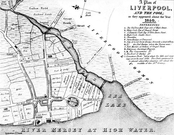
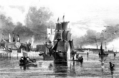
its identity. A map shows the situation in 1805, with the Salthouse Dock, Liverpool's second dock, completed in 1753. The Old Dry Dock stood on the site of Canning Dock and can be seen being used for ship repairs in the engraving on the left from the early 1800s, by which time the waterfront had reached its present position and The Pool had gone forever. The Victoria History of the County of Lancaster (1907) tells us:
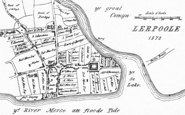
  The first of [the] docks, opened in 1715, was made out of the mouth of a tidal creek re-entering from the estuary, the upper reaches of which were at the same time filled in. This creek, known as the Pool, curved inland in a north-easterly direction along the line of the modern Paradise Street, Whitechapel, and the Old Haymarket for a distance of nearly half a mile. It was fed by two streamlets, one coming from Everton at the northern end of the ridge, while the other ran a more rapid course from a marshy expanse, called the Mosslake, which lay halfway up the slope to the south-east, between the modern Hope Street and Crown Street.
The Pool Area in 1805
The Pool in about 1650
In trying to picture the location and extent of The Pool in present day Liverpool, it is first of all important to realise that the coastline on the 1572 map lay along the line of the modern Strand Street (hence the name). Therefore all of the existing docks and waterfront buildings where built out into the River Mersey.
The opening of The Pool into the river stretched from Canning Dock in the north to the southern end of Salt House Dock. At Parke Roads it was still about 260 yds (240 m) across, roughly from the start of Park Lane to the Chavasse Park steps (where you can get a glimpse of the Old Dock through a glass porthole). The tidal creek followed the line of Paradise Street, Whitechapel, Old Haymarket and Byrom Street, where a dip in the land is still clear.
Where the flood gates were located (the junction of Paradise Street and Paradise Place) and at the ferry at Church Street, the creek was about 100 yds (90 m) across. It maintained approximately this width, plus or minus, as far as the Townsend Bridge (now the rather less historic flyover) at the end of Dale Street.
Tributaries of The Pool including Middle Mill Dale and Moss Lake Brook
Upstream, The Pool followed Byrom street and then branched. One branch went straight on in the direction of Scotland Road and the other, marked on the 1650 map as Middle Mill Dale, went off at a right angle round the present John Moores University buildings (probably the site of the chief water mill of mediaeval Liverpool).
According to the Yates and Perry Map of 1768, it crossed Folly Lane (now Islington) as far as London Road where it branched again. One branch doubled back to Low Hill (near the junction of the present Low Hill and West Derby Road) and the other, the Moss Lake Brook, had its source in the Moss Lake. With regard to the latter I can do no better than quote from Recollections of Old Liverpool (1863), in which an anonymous author recalled the mid-18th century:
  It does not require a man to be very old to remember the pleasant appearance of Moss Lake Fields, with the Moss Lake Brook, or Gutter, as it was called, flowing in their midst. [...] The brook ran parallel with the present Grove Street, rising somewhere about Myrtle Street. [...] Just where Oxford Street is now intersected by Grove Street, the brook opened out into a large pond, which was divided into two by a bridge and road communicating between the meadows on each side. The bridge was of stone of about four feet span, and rose above the meadow level. [...] In winter the Moss Lake Brook usually overflowed and caused a complete inundation. On this being frozen over fine skating was enjoyed for a considerable space.
Upper reaches of The Pool on the Yates and Perry Map of 1768
Abercromby Square
The Moss Lake
One of the most conspicuous features of the early landscape of Liverpool must have been the Moss Lake, a large expanse of bog and water covering an area bounded approximately by a line from near the top end of Lodge Lane, along Smithdown Lane to the top of Brownlow Hill, down to Mount Pleasant and along it to Oxford Street, and then following a line south to Upper Parliament Street and back up to Lodge Lane.
The lake was sufficiently large to provide a considerable impediment to travellers and was the reason for the bend at Smithdown Road and Upper Parliament Street and that in Mount Pleasant at Oxford Street. It was the source of two streams, Moss Lake Brook to the north and an unnamed brook to the south. It was carefully maintained by means of flood gates to serve as a means of cleansing The Pool, which tended to be contaminated with sewage and industrial waste, providing water-mill power and supplying tanneries.
It was drained in the early 1800s and Abercromby Square of 1830 or so was among the first building projects. Nothing remains of the lake today, but the absolutely level plateau with rising or falling ground all around it is still noticeable.
 
Acknowledgements and Further Reading
The engraving of The Pool area is from Lancashire Illustrated, by S. Austin, J. Harwood and G. and C. Pyne, (1831). See also Historic Liverpool: The Pool by Martin Greany.
This is a non-commercial website that is intended entirely for research and educational purposes. If I have unintentionally breached copyright with any images, I hope that the copyright owner will tolerate my usage in the present context, otherwise I will remove the material. Modern colour photographs are by the author.