| Introduction |
| The
earliest map to show Liverpool and the outlying
villages and roads in detail is that by Yates and Perry: A Map of the Environs of
Leverpool drawn from an Actual Survey taken in
the Year 1768 by Wm. Yates and Geo. Perry.
This takes us back to the long lost world of the
old roads and villages surrounding a remarkably
small City of Liverpool. Many of the outlying
settlements predate Liverpool itself. The age of
the railways was just around the corner and rapid
growth of industry
and housing were to follow. But just how lost is the world of
the 18th century? The modern conurbation spreads
over the entire area of this map and more, but
plenty of clues to the past remain. |
| I have made
a careful study this map, the c.1850 Ordnance Survey map and modern street maps and was
surprised to find that almost all of the old
highways and byways can be identified with
current roads. In the old village locations,
isolated pockets still retain some of their
heritage and a number of buildings and other
structures from the 18th century and earlier
survive. The modern courses of old roads,
especially to the south, often retain the
original sandstone field boundary walls, even if
reconstructed. |
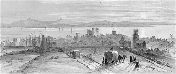
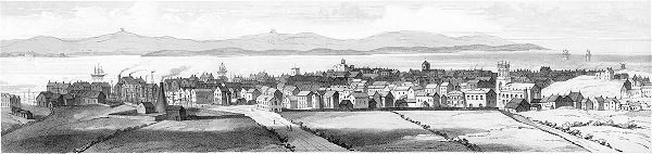
| On the right
are some 18th century views of Liverpool from the
surrounding countryside that give a tantalising
glimpse of the smallness of the urban area and
the sudden transition into rural England. This
extract from The
Stranger in Liverpool, 1812, does the same
in words. |
| |
Crossing the London
road we come to Low-hill, where there is nothing
remarkable to detain the attention. It may,
however, be noticed, that the traveller in
approaching Liverpool in this direction first
obtains a view of the town from this eminence,
which, after a long space of level ground has
been travelled, breaks suddenly upon the sight,
and presents itself to considerable advantage
embosomed in an extensive vale, which sweeps from
the south east to the north, and accompanied with
a pleasing variety of land and marine scenery. |
| Site
Contents |
| This article is a
detailed examination of the Yates and Perry map
in the context of present day Liverpool. You may
after reading it be better placed to picture how
things were 250 years ago and how those times
have shaped the present. I have split the Yates
and Perry map into three sections for the present
purposes. |
|
|
| Where possible I have
used the road names that appear on the Yates and
Perry map and these are distinguished, along with
other named items on the map, by the use of
italics. Failing that I have used road names from
the 1850 Ordnance Survey where possible,
otherwise the modern names. The keys to the maps
should make clear how the old names relate to the
modern ones. It might be worth bearing in mind
that not all of the names current in 1850 would
have been in use in 1768. |
| |
| Acknowledgements |
| The drawings of
Liverpool in 1715 and 1725 are from original
works engraved by
W.G. Herdman for his Pictorial Relics of
Ancient Liverpool, 1843, made available by Ancestry Images, with thanks. The view from Everton was engraved
from a picture by E. Dayes published in Aiken's 40
Miles Round Manchester, 1795. |
| Info |
| This site is
the work of Laurence Scales and is part of allertonOak. |
| The site is
entirely non-commercial and is intended for
educational purposes. |
| The site is
best viewed at a minimum of 1024x768 pixels
resolution. The page layout will be optimal with
your browser at about 1200 pixels wide. |
| The modern
colour photographs on this site are by the author
except where specified; you may copy these for
non-commercial purposes only, but please place an
acknowledgement to www.allertonoak.net at their point of use. |
|
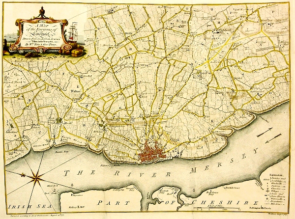 |
| The
Yates and Perry Map of 1768 |
 |
| Liverpool
from St. James's Mount in 1715 |
 |
| Liverpool
from St. James's Mount in 1725 |
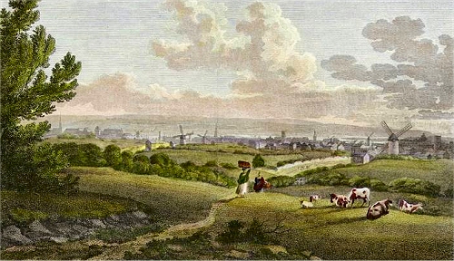 |
| Liverpool
from Everton in 1795 |
|