 |
| Prince's
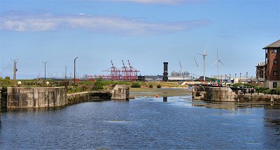
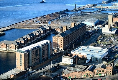
Dock, Half Tide Dock and the Waterloo Docks |
 |
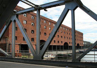
| The
Waterloo Grain Warehouse |
 |
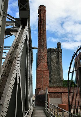
| The
Victoria Clock Tower and Stanley Dock Lift Bridge |
 |
| Stanley
Dock Warehouse |
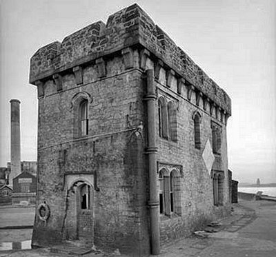 |
| The
Salisbury Dockmaster's Office |
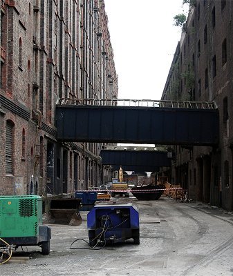 |
| Pneumonia
Alley |
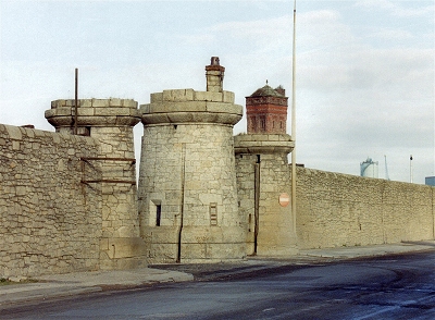 |
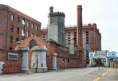
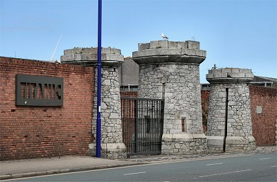
| The
Entrance Gates to Bramley-Moore Dock |
|
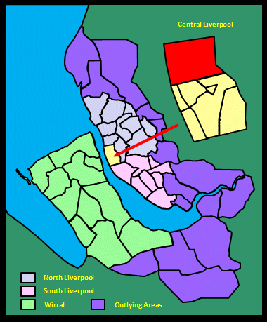
| The Development of the
North Docks |
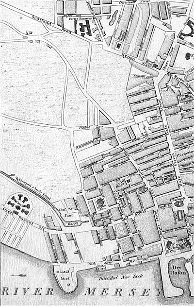
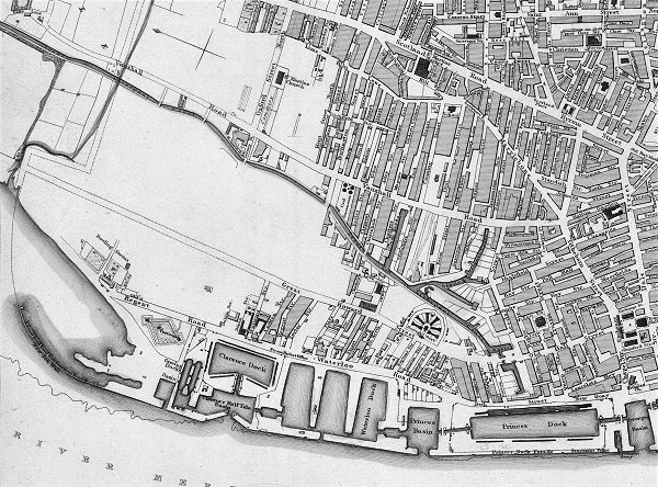
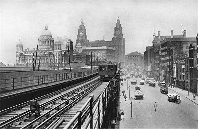
| Construction of Prince's
Dock (named after the Prince Regent) by John
Foster began in 1810 but was only completed in
1821. It is shown on Sherriff's map along with
the adjacent Prince's Half Tide Dock. The latter,
with its lock gate to the Mersey, opened in 1810
but was rebuilt in 1868. Prince's Dock was closed
to shipping in the 1980s. |
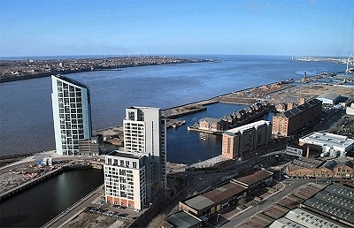
| There has been sporadic
redevelopment of the dockside areas since 1988,
but according to the Pevsner Guide, 'The
architecture is both bland and overly fussy, and
the lifeless monoculture could be a business park
anywhere. Adjoining the Pier Head, architectural
standards should be far higher'. However, 2017
should see the start of the ambitious £300
million next phase of the Liverpool Waters
project in this area. |
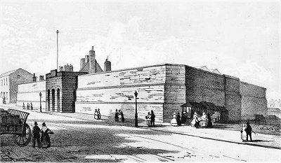
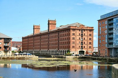
| Next along, Waterloo
Dock opened in 1834, and was redeveloped into
east and west branches in 1868 (compare the 1836
and 1890 maps). It was designed, like the rest of
the docks discussed here, by Jesse Hartley and
named after the Battle of Waterloo. The Waterloo Grain
Warehouse of 1866-8 was designed by G.F. Lyster
and the overall facility constituted the world's
first bulk American grain handling facility. The
surviving warehouse, originally the easternmost
of three such, has been converted to apartments. The Waterloo Dock system closed to
shipping in 1988. |
| Next up were Victoria
Dock (after Princess, soon Queen, Victoria) and
its neighbour Trafalgar Dock (after the Battle of
Trafalgar), which opened together in 1836. The
former was altered in 1848 to remove its river
entrance. It was partly filled in in 1972 and the
remainder followed in 1988. The latter was used
as a landfill site in the early 1990s. |
| Clarence Half Tide Dock
was connected by a lock system to Trafalgar Dock
and on to Clarence Dock, Clarence Graving Basin
and two graving docks. They were named after the
Duke of Clarence, later William IV. They opened
in 1830 and were enlarged in 1853. They were
purpose-built steamship docks as a fire
prevention measure given that so many wooden
ships were using the docks to the south. The
docks closed in 1929 and, except for the graving
basin and graving docks, were filled in the
following year. The site was subsequently used
for the Clarence Dock Power Station, demolished
in 1994, whose three huge chimneys were a
Liverpool landmark. |
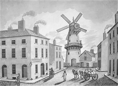
| On Gage's 1836, the
docks terminate here with landfill and a sea
wall. Regent Road petered out by the North Shore
Mill, where there were bowling greens. Between
there and Clarence dock was a Napoleonic
fortress, presumably built in the 1820s about the
same time as Fort Perch Rock at New Brighton, but
little spoken of. It was demolished in the next
phase of dock building. |
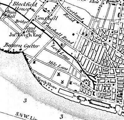
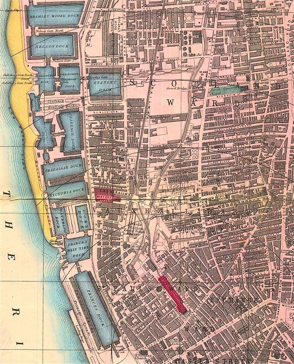
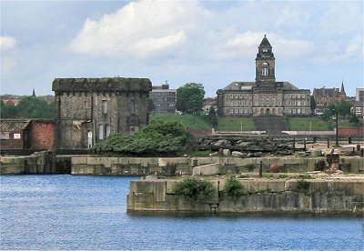
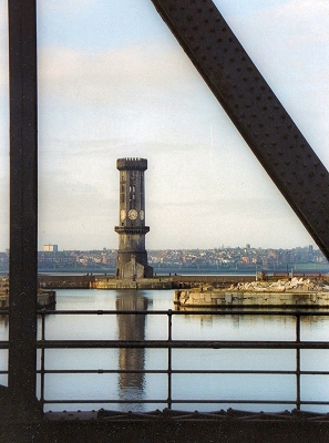
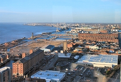
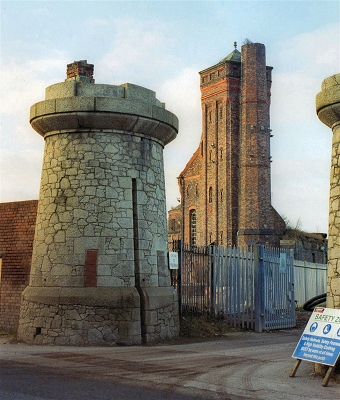
| The Salisbury,
Collingwood and Stanley Dock system of 1848 was
the next to be constructed. Salisbury Dock was a
half-tide dock connected to the river by two
locks and on to Collingwood Dock, named after
Vice Admiral Cuthbert Collingwood. The hexagonal,
castellated Victoria Tower, designed by Jesse
Hartley and completed in 1848, is a clock (one
per face) and bell tower that used to give time
to neighbouring docks and passing ships and ring
out high tide and warnings. It also provided a
flat for the piermaster. Here also is the former Dock
Master's Office, also built by Hartley using
masonry in his trademark Cyclopean style
(see below). |
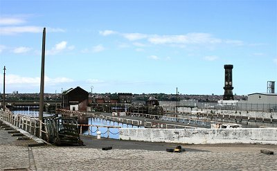
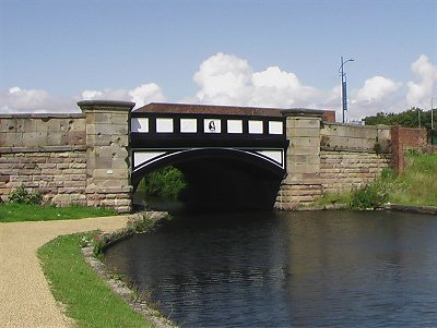
| Collingwood Dock in turn
connects under a lift bridge to Stanley Dock,
named after the local family and the only one of
Liverpool's docks to be built inland, and on to
the Leeds and Liverpool Canal, thereby providing
a link from the canal to the river. An octagonal hydraulic
tower and pumphouse was used to provide power for
lifting devices, capstans, locks, bridges and
tobacco presses. Hartley's frequent use of
turrets, arrow slits and other trappings of the
mediaeval castle for such buildings was intended
to reinforce the impression of impregnability. |
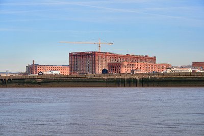
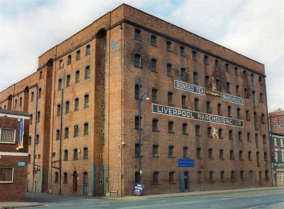
| The Stanley
Dock warehouses, designed, like the Albert Dock
warehouses, by Jesse Hartley, were opened in
1856. The warehouse on the south side of the dock
was demolished and the dock partly filled in in
1901 to make way for the huge Tobacco Bonded
Warehouse. This vast building of 1901 designed by
A.G. Lyster is 12 storeys high and, with 27
million bricks, it is reputed to be the largest
brick building in the world. The narrow
passageway between it and the adjacent warehouse,
where the wind howls and the sun rarely shines,
was nicknamed Pneumonia Alley. At the
back, the Bonded Tea Warehouse, originally the
Clarence Warehouse, was Liverpool's largest
warehouse when constructed in 1844. These
warehouses form the last significant remnant of
what was once the characteristic landscape of the
dock hinterland. |
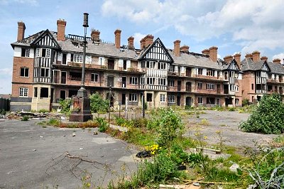
| Until recently
the whole area was derelict: 'easily the most
impressive and the most evocatively derelict dock
in Liverpool', according to the Pevsner Guide.
However it has been subject to a £130m
redevelopment with the north Stanley Dock
warehouse becoming a 4-star hotel. The next
phase, now (2017) under way, includes renovating
the Tobacco Bonded Warehouse, creating
apartments, bars and shops, and removing the
centre of the building to create a garden
courtyard. There are plans to redevelop the whole
area, as has happened
so successfully in the south docks. |
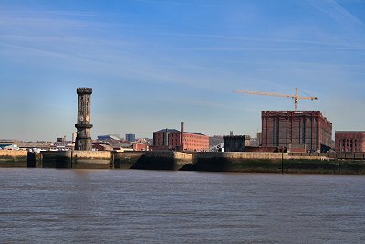
| Next to the north and
connected to Collingwood Dock are Nelson Dock and
Bramley Moore Dock, both of 1848. The latter was
named after John Bramley-Moore, chairman of the
dock committee, and brings us to the northern
edge of the Liverpool Borough. The dock walls and
entrance gates here are good places to examine
Hartley's Cyclopean style, extraordinarily intricate
stone construction reminiscent of dry stone
walling in its dovetailing of irregular blocks.
The periodic dock gates with their castellated
gatepiers were intended to give the impression of
impregnability and hence, not always
successfully, deter pilferers. Bramley Moore Dock also has a
large surviving Hydraulic Accumulator Tower, once
used to provide hydraulic power to drive
machinery. A heavy atmosphere of decay still
broods over much of the northern dock area. |
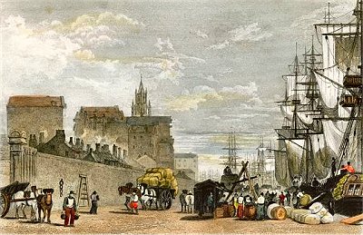
| The
Prince's dock, constructed under an act passed in
the 51st of George III, was opened with great
ceremony on the 19th of July, 1821, the day of
the coronation of George IV.; it is 500 yards in
length, and 106 in breadth. On the north is a
spacious basin belonging to it, and on the south
it communicates with the basin of George's dock:
at the north end is a handsome dwelling-house for
the dock-master, with suitable offices; and at
the south end a house in which the master of
George's dock resides. Spacious sheds called
'transit sheds' have been recently built on the
west quay, into which a ship may discharge her
cargo immediately on her arrival, under the
surveillance of the custom-house officers, the
goods to be afterwards distributed to the
different owners: by this convenience, much delay
is avoided. |
| Northward
of the basin belonging to this dock are three
docks called the Waterloo, the Victoria, and the
Trafalgar; the first was opened in 1834, and the
two others in 1836: the Trafalgar dock is
principally used for steam-vessels. Still further
in the same direction are the Clarence dock and
half-tide basin, completed in 1830, and
appropriated solely to steam-vessels frequenting
the port; also two capacious graving docks.
Beyond these graving docks, a vast accession of
accommodation is now in course of construction,
under the provisions of an act passed in the 8th
Victoria, consisting of eight separate docks and
six graving docks, the former having an aggregate
water area of above 60 acres, and quay space
measuring 3 miles and 257 yards in length. These
splendid docks will be capable of admitting
steamers of the largest class, and will
communicate, by a series of locks, with the Leeds
canal, an improvement of the greatest importance.
[TDE] |
|
 |
| The
Waterloo Docks and Grain Warehouse |
 |
| The
Stanley Dock Area and Tobacco Warehouse |
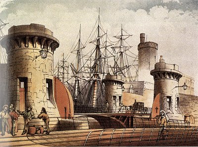 |
| Stanley
Dock Entrance and Policemen's Lodges c.1860 |
 |
| The
Victoria Clock Tower and Salisbury Dock |
 |
| Stanley
Dock Lift Bridge and Hydraulic Tower |
 |
| The
Bonded Tea Warehouse |
 |
| Hydraulic
Accumulator Tower at Bramley-Moore Dock |
|